
21.3
PDI
24.8 mi
DISTANCE
4,858 ft
GAINED
3.7 %
AVG. GRADE
FULL CLIMB STATS
INTRO
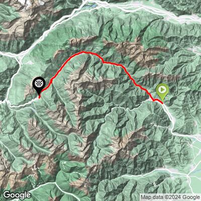
Sestrières South is the long way up to Sestrières: 40.0 km (24.8 mi) from Dubbione, in Pinasca, up the Val Chisone to the ski resort at 2035 m (6,677 ft). It gains 1481 m (4,858 ft) at only a 3.7% average, so this is a test of patience and pacing rather than steepness, with most of the real climbing saved for the final miles.
This is the climb that opened Stage 4 of the 2024 Tour de France, a categorized climb from Pinerolo of roughly 40 km before the race went on to Montgenèvre and the Galibier. Sestrières has a long history with both major tours: the Tour de France first came here in 1952, when Fausto Coppi won, Lance Armstrong won a stage here in 1999, and Stage 20 of the 2025 Giro d'Italia finished in the resort on May 31, 2025 after the Colle delle Finestre.
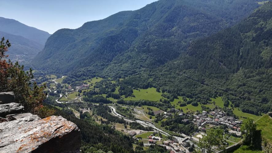
The road follows the valley through Perosa Argentina, Roure, Fenestrelle and Pragelato, past the walls of the Fenestrelle fort, before the grade finally steepens in the last 5 km (3.1 mi). Riders consistently describe the surface as excellent.
PLAN YOUR ROUTE
 We've partnered with Sherpa-Map.com to bring you the best route planning tool. With a PRO Membership you can use this climb as a reference when creating your route.
 Our route covers 40.0 km (24.8 mi) from 558 m (1,832 ft) to 2,035 m (6,677 ft), a gain of 1,481 m (4,858 ft) at 3.7% on average. The first 5 km (3.1 mi) average just 2.2%, the middle of the climb sits between about 3.4% and 4.4%, and there is a nearly flat stretch of about 1.8% between 25 and 30 km (15.5-18.6 mi). The final 4.8 km (3.0 mi) are the hardest, averaging 6.2%.
The steepest 10 km (6.2 mi) average 5.2%, the steepest 5 km (3.1 mi) average 6.4%, the steepest 2 km (1.2 mi) average 7.5%, and the steepest 1 km (0.6 mi) averages 8.7%. The steepest half-kilometer (0.3 mi) averages 10.1% and the steepest quarter-mile (0.4 km) averages 12.2%. Save something for the top.
Roadway: The road is the SP 23 del Colle di Sestrières, paved the whole way, and riders consistently describe the surface as excellent. Riders also report that the upper road was freshly asphalted ahead of the 2025 Giro d'Italia. Expect the occasional closure on race days.
Traffic: Traffic is real but manageable: this is the main road from the valley to a ski resort, and riders often describe it as heavy at busy times. Early morning is the best time to ride, and a rider who climbed it right after the Tour left Pinerolo in 2024 found it very light.
Parking: Our route starts in Dubbione, a small village of Pinasca, so most riders will park in Pinerolo, the larger town about 10 km (6 mi) down the valley, and add that gentle valley riding to the climb, as the Tour did in 2024. Starting from Pinerolo makes the climb roughly 50 km (31 mi) long.
Standard road gearing is fine here since the grade stays under about 6.5% over any 5 km (3.1 mi), and a compact is only worth it for the final 5 km (3.1 mi). The challenge is the length: a long ride for most riders, so pace the valley miles and eat early.
Riders report plenty of water spigots along the first two-thirds of the route, and Sestrières has restaurants and hotels at the top. In the off-season some hotels and restaurants may be closed. Sestrières sits at 2,035 m (6,677 ft), noticeably cooler than the valley floor, so pack a layer for the descent.
Before heading out on any cycling adventure check out our Things to Bring on a Cycling Trip and use our interactive check list to ensure you don't forget anything.
The Val Chisone is a good place to spend a day around the climb. The Fenestrelle fort, the largest alpine fortification in Europe, is visible from the valley road: it covers 130 hectares, has a 3 km (1.9 mi) wall and a covered staircase of 3,996 steps, and was named among the world's 100 most important archaeological sites by the World Monuments Fund in 2007.
Pragelato, in the valley below, hosted the ski jumping at the 2006 Winter Olympics, when Sestrières itself was the alpine skiing venue. The resort was built in the 1930s by Giovanni Agnelli, and its twin hotel towers are still the landmark at the top, along with a monument to Fausto Coppi.
Sestrières is approached by other roads too, and our Sestrières and Sestrières - Bousson pages cover the approach from the Cesana side. Because the summit is above 2,000 m (6,562 ft), check conditions at the base and the top with our Weather tool before you go.
ROUTE MAP
MEMBER RATING
CURRENT WEATHER
PJAMM TRIPS ADVENTURE STARTER BUNDLES
Check out PJAMM Adventure's prepackaged (self-guided) cycling trips. They will help you plan, document and conquer your next adventure.
NEARBY CLIMBS (0) RADIAL PROXIMITY
FROM No Climbs Found
MEMBER REVIEWS & COMMENTS
Let us know what you thought of this climb. Signup for our FREE membership to write a review or post a comment.
Already have an account?
LOG IN HERE
golmstead
I rode this route starting in Pinerolo, instead of in Pinasca. So the route turned out to be 31 miles of climbing. Traffic was very light, given we started right after the pro peloton left on the TdF. Excellent road, lots of great scenery, and plenty of water spigots along the way to top off bottles, at least in the first two-thirds of the ride. The pitch is generally consistent, but it rises sometimes and flattens in others. Really loved the climb and the crêpes at the top. My only advice is to top off bottles at each spigot because I can't really say where the last one on the road will be.
