
30.5
PDI
10.2 mi
DISTANCE
3,953 ft
GAINED
7.3 %
AVG. GRADE
FULL CLIMB STATS
Page Contributor(s): Chris Monson, Blanding, UT
INTRO
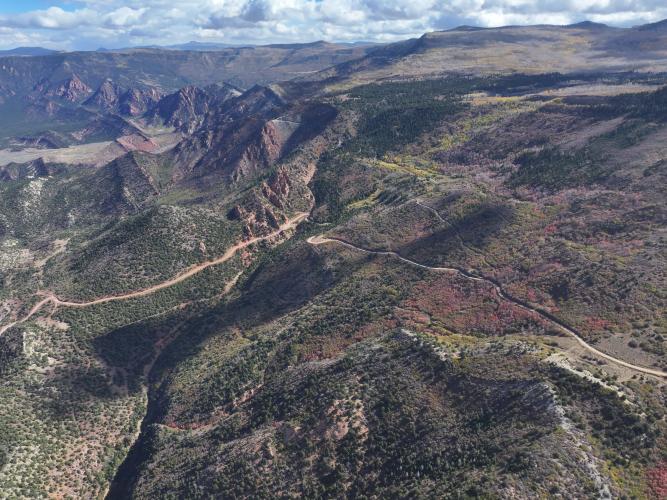
This is a spectacular and challenging gravel climb out of the small town of Kanarraville in Iron County, Utah, climbing the Hurricane Cliffs immediately north of the Kolob Canyon entrance to Zion National Park. Over 10.24 miles it gains 3,953 ft at an average grade of 7.3%. AKA, this one's pretty damn tough.
The road climbs from pinyon-juniper foothills up through alpine meadows and stands of birch on the Kolob Terrace, with big views back over Cedar Valley the higher you get. Once you crest the top, the road continues as Upper Basin Road toward Kolob Reservoir - this climb is also the start of the longer Cedar City Fire Road route for riders who want to keep going.
Kanarra Mountain Road is maintained by Iron County as access to private ranches in the Bean Hill area, and is passable by any vehicle when dry, but it's closed outright through the winter and doesn't reopen until county crews assess conditions in late spring - worth checking status before you plan a ride outside summer.
PLAN YOUR ROUTE
 We've partnered with Sherpa-Map.com to bring you the best route planning tool. With a PRO Membership you can use this climb as a reference when creating your route.
 The grade holds a steady, demanding pace for virtually the whole 10.24 miles - there's no flat stretch to recover on. The steepest pitches come in the lower and middle sections as the road switchbacks up the Hurricane Cliffs; once you're up on the Kolob Terrace the gradient eases slightly through the alpine meadows near the top, but this is a sustained, leg-testing effort throughout rather than a climb with one standout pitch.
Roadway: Improved dirt and gravel the entire way, county-maintained for the private ranches it serves. It's passable by a standard vehicle when dry, but expect washboard and looser, rockier sections as you climb into the upper meadows. The road is closed each winter and reopens in late spring once Iron County has assessed conditions.
Traffic: Very light. This is a county access road to ranches on the Bean Hill area, not a through route, so you'll mostly have it to yourself outside of occasional ranch or recreational 4x4 traffic.
Parking: Start from the town of Kanarraville, just off Highway 91 about 12 miles south of Cedar City, where the gravel begins at the edge of town.
A gravel or mountain bike is the right tool here - the surface gets loose and rocky in the upper miles. Carry all the water you'll need; there are no services once you leave Kanarraville. Sun protection matters on the lower, more exposed switchbacks, and it's worth packing a light layer for the descent since the top sits well above 8,500 ft.
Before heading out on any cycling adventure check out our Things to Bring on a Cycling Trip and use our interactive check list to ensure you don't forget anything.
Cedar City, about 12 miles north, is the nearest base for lodging, food, and bike shops. We've been super impressed with Centro Woodfired Pizza the last time we were there.
Kanarra Mountain Road is closed through the winter and typically doesn't reopen until Iron County assesses it in late spring, so check current status before planning a ride outside summer. Combine it with the Cedar City Fire Road route for a longer point-to-point ride, and consider a stop at nearby Kanarra Falls (Kanarra Creek) if you want to make a full day of it.
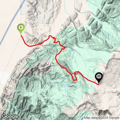
ROUTE MAP
MEMBER RATING
CURRENT WEATHER
PJAMM TRIPS ADVENTURE STARTER BUNDLES
Check out PJAMM Adventure's prepackaged (self-guided) cycling trips. They will help you plan, document and conquer your next adventure.
NEARBY CLIMBS (0) RADIAL PROXIMITY
FROM No Climbs Found
MEMBER REVIEWS & COMMENTS
Let us know what you thought of this climb. Signup for our FREE membership to write a review or post a comment.
Already have an account?
LOG IN HERE
