
24.5
PDI
13 mi
DISTANCE
3,836 ft
GAINED
5.6 %
AVG. GRADE
FULL CLIMB STATS
Page Contributor(s): Scott Herrin, Boulder CO; Jackson Haftel
INTRO
Lands End Road climbs the dramatic western escarpment of Grand Mesa, the world's largest flat-topped mountain, from the high desert near Whitewater, Colorado up to Lands End Observatory on the rim. The climb covers 13 miles and gains 3,836 feet at a moderate 5.6% average grade, starting around 6,025 feet and topping out near 9,861 feet.
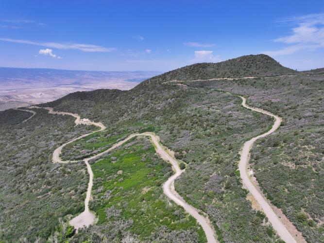
The road is a mix of pavement and well-maintained gravel, roughly half and half, built in stages: the lower section was cut by 200 WWI veterans in 1933-34 (once nicknamed "Veterans Road"), while the WPA and CCC completed the route to the top of the mesa by 1934. The historic Lands End Observatory building itself, constructed by the Forest Service and WPA in 1936-37, has been closed and boarded up since 2022, but the viewing area outside it still delivers a sweeping panorama over western Colorado and into eastern Utah.
The road is seasonal - snow typically closes the upper stretch from late fall through spring, and the lower BLM-managed gate is separately closed every year from December 1 through May 1 for a wildlife closure, regardless of snow conditions. Full-size vehicles aren't recommended on the unpaved sections, which makes this a natural fit for a gravel bike.
PLAN YOUR ROUTE
 We've partnered with Sherpa-Map.com to bring you the best route planning tool. With a PRO Membership you can use this climb as a reference when creating your route.
 Lands End Road is a long, steady grinder rather than a pitch-and-recover climb - the grade barely varies across its 13 miles. Even the steepest quarter-mile only averages 6.7%, and the steepest full mile holds just 6.25%, both close to the overall 5.6% average.
Zoomed out further, the steepest 5-mile stretch still sits at 5.8%. In practice that means a consistent, moderate effort for the better part of two hours rather than sharp ramps to brace for - the main challenge is the sheer length and total elevation gain (from 6,025 feet up to nearly 9,861 feet), not the steepness of any single section.
Roadway: Two PJAMM contributors who've ridden this recently both rate the surface a 2 on a 1-to-5 smoothness scale. In their words: "Super doable on a gravel bike, road is probably a 2 on a 1-5 scale on smoothness on the way up, it can be pretty brake bumpy on the way down but besides that there isn't really any rough or rocky spots, just some loose corners and brake bumps" - Jackson Haftel. "Lands End Road was running really well last time I was up there... It's ideal going up on the gravel bike but you definitely have to take a little more time on the way down" - Vaughn Veenendaal. Roughly half the route is paved and half is well-maintained gravel, built up in stages between 1933 and 1934.
Traffic: Light. This is a remote Forest Service/BLM road, not a through route, though it does see occasional sightseers driving up to the Lands End Observatory overlook in season.
Parking: There's no formal trailhead; riders typically start from a pullout along CR-100 in the lower section south of Whitewater. The road is seasonal - snow closes the upper stretch in winter, and the lower BLM-managed gate is separately closed every year from December 1 through May 1 for a wildlife closure - plan rides for late spring through fall.
A gravel bike is the right call here, per riders who've done it - both contributors quoted above rode it successfully on gravel bikes, though loose corners and brake-bumps on the descent call for more caution and speed control coming down than the ride up requires.
This is a remote road with no services anywhere along the route - no water, food, or bike shops - so carry everything you need for a 13-mile, roughly 3,800-foot effort at elevation. The upper mesa sits close to 10,000 feet, where weather can turn quickly even in summer, so pack a layer for the descent.
Before heading out on any cycling adventure check out our Things to Bring on a Cycling Trip and use our interactive check list to ensure you don't forget anything.
The nearest services are in Whitewater or Grand Junction, roughly 20-25 miles from the base of the climb via US-50 and CR-100 - stage there for food, lodging, and bike shop needs.
Because the road is seasonal (see Roadway & Parking), plan this one for late spring through fall, and check current conditions with the Grand Mesa, Uncompahgre and Gunnison National Forests' Grand Valley Ranger District before heading out.
Lands End Road connects directly to the Grand Mesa Scenic and Historic Byway at the top - use our Sherpa Map route builder to plan a bigger loop combining this climb with other routes across the mesa.
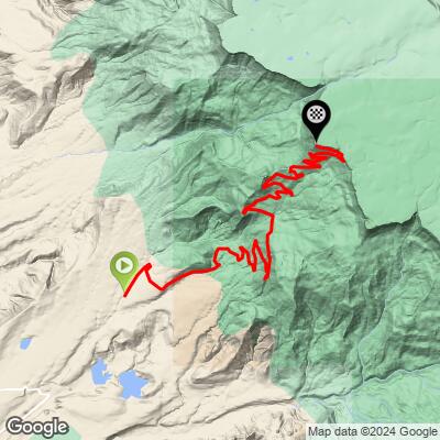
ROUTE MAP
MEMBER RATING
CURRENT WEATHER
PJAMM TRIPS ADVENTURE STARTER BUNDLES
Check out PJAMM Adventure's prepackaged (self-guided) cycling trips. They will help you plan, document and conquer your next adventure.
NEARBY CLIMBS (0) RADIAL PROXIMITY
FROM No Climbs Found
MEMBER REVIEWS & COMMENTS
Let us know what you thought of this climb. Signup for our FREE membership to write a review or post a comment.
Already have an account?
LOG IN HERE
