
24.7
PDI
5.7 mi
DISTANCE
2,938 ft
GAINED
9.8 %
AVG. GRADE
FULL CLIMB STATS
Page Contributor(s): John Berude, Berkeley, CA
INTRO
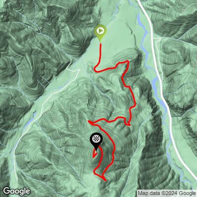
Sun Top Lookout from Forest Road 7315 is a short, brutally consistent gravel climb in the Mt. Baker-Snoqualmie National Forest east of Enumclaw, Washington. From its start near the White River along FR-7315, the climb covers 5.7 miles and gains 2,938 feet at an average grade of 9.8% - all on a one-lane dirt-and-rock forest road with essentially no flat sections to recover on.
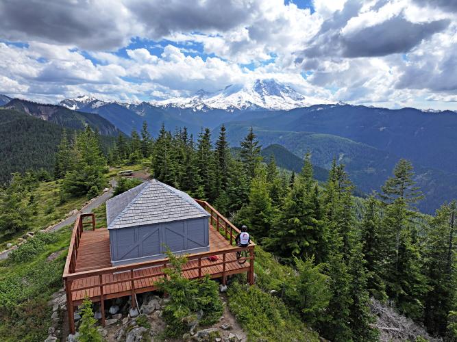
The payoff is the view. Suntop Lookout, a working fire lookout built in 1933 and still staffed by volunteers each summer, sits at roughly 5,270 feet with an open look at Mt. Rainier just 10 miles to the south, plus the central Cascades, the Olympic Mountains, and on clear days Mt. Baker 150 miles to the north. An accessible ramp leads the final stretch to the lookout deck, and a roughly 3,000-foot drop to the White River below gives the summit a genuinely exposed, alpine feel despite the modest overall distance.
Current conditions: as of August 2026, this entire stretch of FR-7315 - including the Suntop Trailhead and the lookout itself - is closed to all public access, cyclists included, under the U.S. Forest Service's Grand Park 2 Fire Closure Order, in effect August 10 through October 31, 2026 or until rescinded sooner. Check the Mt. Baker-Snoqualmie National Forest's alerts page before planning a ride here in 2026.
PLAN YOUR ROUTE
 We've partnered with Sherpa-Map.com to bring you the best route planning tool. With a PRO Membership you can use this climb as a reference when creating your route.
 There's no easing into this one - the road tips up from the first pedal stroke and stays pitched for the full 5.7 miles. The steepest quarter-mile averages 12.7%, and even the steepest full mile still holds 12.0%, so the grade barely relents anywhere along the way.
Zoomed out, the steepest 5-mile stretch still averages 10.3% - only a shade below the overall 9.8% average - which tells you this is a climb of sustained, even effort rather than isolated ramps followed by recovery. Expect to be seated and grinding in a low gear for essentially the entire ride, with the loose dirt-and-rock surface adding real resistance on top of the gradient itself.
Roadway: FR-7315 is a one-lane dirt-and-rock Forest Service road the entire way - unpaved, narrow, and prone to washboard and potholes after winter, with the Forest Service noting recurring deadfall on the lower stretch that isn't always cleared until well into the season. There's no shoulder, so riders share the single lane directly with any oncoming traffic.
Traffic: Light but not zero - day-use visitors driving to the picnic site and lookout, plus occasional forest maintenance vehicles, use the same lane. Blind corners are frequent, so ride defensively and be ready to yield on narrow sections.
Parking: A Forest Service Recreation Pass is required to park at the Suntop Trailhead or Suntop Picnic Site ($5/day or $30/year).
Current closure: As of August 2026, the entire length of FR-7315 - including the Suntop Trailhead and Suntop Lookout - is closed to all public access, cyclists included, under the Forest Service's Grand Park 2 Fire Closure Order (Order #06-05-26-13), in effect August 10 through October 31, 2026 or until rescinded sooner. Confirm the closure has been lifted on the Mt. Baker-Snoqualmie National Forest alerts page before riding here.
This is a remote, amenity-free forest road - there's no food, water, or bike shop anywhere along FR-7315 or the nearby stretch of WA-410, so arrive full and carry more than you think you'll need for a climb this steep.
A gravel or mountain bike with sturdy, wide tires (35c or wider) is the right tool here - the loose dirt-and-rock surface and sustained 10%+ pitches punish narrow tires and high-pressure setups. Low gearing matters more than usual given how little the grade ever relents.
There's no potable water at Suntop Lookout or the picnic area, so top off before you leave pavement. A vault toilet is available at the trailhead/picnic site.
Before heading out on any cycling adventure check out our Things to Bring on a Cycling Trip and use our interactive check list to ensure you don't forget anything.
The nearest town with real services is Enumclaw, WA, about 24 miles west via WA-410 - stage there for gas, food, and bike shop needs, since there's nothing closer. Camping isn't allowed at the lookout itself, but Dalles Campground and Silver Springs Campground both sit along WA-410 within a few miles of the FR-7315 turnoff.
Suntop Lookout is staffed by volunteers from mid-June through late September and open to visitors 8am-5pm during that window - outside those months, or on busy weekends when parking fills, the gate near the top may be closed. Check current conditions and the active fire closure (see Roadway & Parking) before you go.
Highway 410 is home to several other notable climbs in the area - use our Sherpa Map route builder to string together a bigger multi-climb day starting from Suntop.
ROUTE MAP
MEMBER RATING
CURRENT WEATHER
PJAMM TRIPS ADVENTURE STARTER BUNDLES
Check out PJAMM Adventure's prepackaged (self-guided) cycling trips. They will help you plan, document and conquer your next adventure.
NEARBY CLIMBS (0) RADIAL PROXIMITY
FROM No Climbs Found
MEMBER REVIEWS & COMMENTS
Let us know what you thought of this climb. Signup for our FREE membership to write a review or post a comment.
Already have an account?
LOG IN HERE
