
26.9
PDI
17.7 mi
DISTANCE
4,172 ft
GAINED
4.4 %
AVG. GRADE
FULL CLIMB STATS
Page Contributor(s): Jeremiah Bishop, Harrisonburg, VA; Logan Rhodes, Lake City, CO; Donncha Cuttriss; Kirby Bryan Durango, CO
INTRO
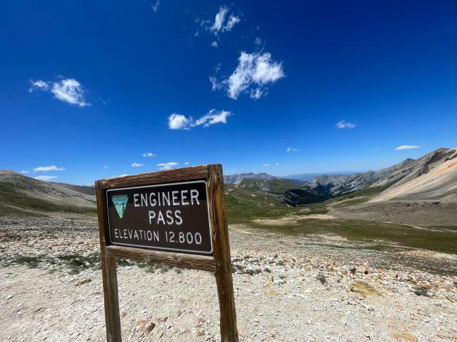
Engineer Pass East is the Lake City side of one of the most famous high-alpine roads in Colorado - a 17.7-mile gravel climb that follows Henson Creek out of town and gains 4,172 feet to the 12,845-foot summit of Engineer Pass, on the Ouray County line in the San Juan Mountains. It's part of the legendary Alpine Loop, the 65-mile network of old mining roads connecting Lake City, Silverton, and Ouray.
The lower half is graded, well-maintained gravel that's passable to passenger cars, passing through the Capitol City ghost town about 9 miles in - once a mining camp of 400 people that briefly hoped to become Colorado's state capital, now reduced to a few ruins including a photogenic old post office. Past Capitol City the road climbs into rougher, high-clearance-4WD territory, with chunky, rocky surface that PJAMM contributors consistently rate as tough on a gravel bike - doable, but slow going, especially in the final few miles.
At 12,845 feet, this is genuinely high-altitude riding through alpine tundra, with views across the San Juans that are hard to match. Riders comfortable with rough gravel sometimes continue over the top and down the significantly rougher west side toward Silverton.
PLAN YOUR ROUTE
 We've partnered with Sherpa-Map.com to bring you the best route planning tool. With a PRO Membership you can use this climb as a reference when creating your route.
 See more details and tools regarding this climb's grade via our interactive Profile Tool.
Roadway: The first roughly 9 miles out of Lake City to Capitol City are graded, well-maintained gravel - passable to standard passenger cars in summer. Beyond Capitol City, County Road 20/Engineer Pass Road becomes rougher and rockier, the kind of surface that calls for 4WD and high clearance in a vehicle; PJAMM contributors consistently rate this upper section 4-5 out of 5 for roughness on a gravel bike, with chunky rock that's slow and technical even on wide tires. The west side toward Silverton is significantly rougher and steeper than this Lake City side - contributors recommend riding east to west if attempting both.
Traffic: Light to moderate in summer - this is a popular 4x4/OHV route as part of the Alpine Loop, so expect Jeep and side-by-side traffic, especially on weekends in July and August, with essentially no traffic in the shoulder season or once the pass closes for winter.
Parking: Start from Lake City - from town, take 2nd Street to Bluff Street, then continue onto County Road 20 (Henson Creek Road/Engineer Pass Road) heading west.
Capitol City, about 9 miles in, has no services today - it's a ghost town - so the last real services are in Lake City. Fuel up and fill bottles before you start.
Wide gravel tires and low gearing are essential for the rocky upper section - several contributors specifically note this climb is rough enough that a standard gravel bike is a struggle above Capitol City, and a couple recommend treating that stretch more like a mountain bike ride.
At nearly 13,000 feet, weather changes fast - pack layers and be ready to turn around if afternoon thunderstorms build, which is common in the San Juans in summer.
Before heading out on any cycling adventure check out our Things to Bring on a Cycling Trip and use our interactive check list to ensure you don't forget anything.
Engineer Pass is only snow-free for a short window - typically from around late June through mid-October, though the exact opening date shifts year to year with snowpack, so check current Hinsdale County road conditions before you go.
Start early. This is a popular 4x4 route in summer, and an early start means less dust and traffic from OHV/Jeep tours, plus a better shot at beating afternoon thunderstorms at altitude.
Lake City has all the food, lodging, and basic bike support you'll need to stage this climb - there's nothing beyond Capitol City until you're over the pass.
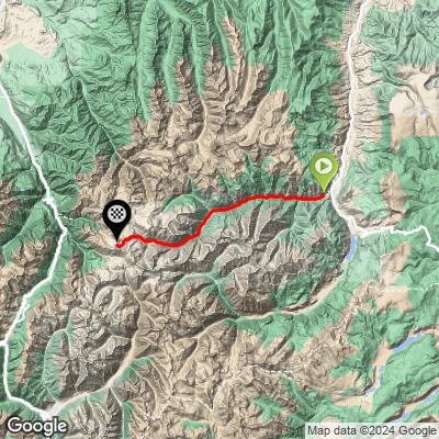
ROUTE MAP
MEMBER RATING
CURRENT WEATHER
PJAMM TRIPS ADVENTURE STARTER BUNDLES
Check out PJAMM Adventure's prepackaged (self-guided) cycling trips. They will help you plan, document and conquer your next adventure.
NEARBY CLIMBS (0) RADIAL PROXIMITY
FROM No Climbs Found
MEMBER REVIEWS & COMMENTS
Let us know what you thought of this climb. Signup for our FREE membership to write a review or post a comment.
Already have an account?
LOG IN HERE
