
23
PDI
9 mi
DISTANCE
3,590 ft
GAINED
6.6 %
AVG. GRADE
FULL CLIMB STATS
Page Contributor(s): Sam Sonne, Seattle, Washington
INTRO
Mount Washington is a roughly 9-mile, one-way climb in Washington's Cascade foothills that gains close to 3,600 feet, starting flat along the old railroad grade from Rattlesnake Lake before turning sharply uphill onto the Mount Washington Trail inside Olallie State Park. It's one of the steeper, rougher climbs in the PJAMM database - sections higher on the mountain average well into double digits, with loose, jumbled rock underfoot much of the way.
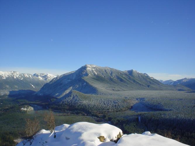
This isn't a groomed gravel road; it's a rugged trail that mixes hiking-trail and mountain-bike-trail character. It's tough but doable on a gravel bike with wide, knobby tires, with some steep sections that have only marginal traction - exactly the profile of a mountain-bike trail, not a smooth gravel road. Along the way, the route passes a small cave used by rock climbers for training, opens through young forest scarred by old logging and wildfire, and finishes in a wildflower meadow with sweeping views of Mount Rainier, Mount Si, and the Middle Fork Snoqualmie Valley.
The trail sits within Olallie State Park and requires a Discover Pass for parking at the trailhead. It's rocky and loose year-round, and the mountain holds snow well into late spring, so early- and late-season riders should expect to need traction gear higher up. Trail junctions are marked informally - small cairns and an old hand-carved tree mark rather than signage - so this is a route best attempted with a GPS track or solid route-finding experience.
PLAN YOUR ROUTE
 We've partnered with Sherpa-Map.com to bring you the best route planning tool. With a PRO Membership you can use this climb as a reference when creating your route.
 Mount Washington gains roughly 3,600 feet over about 9 miles for an overall average near 7.5%, but that number understates the real character of the climb. The first several miles along the old railroad grade from Rattlesnake Lake are essentially flat; nearly all the elevation is packed into the final climb up the Mount Washington Trail itself, where sustained pitches run well into the teens and short sections have been measured at grades over 50%.
Expect a ride that's front-loaded with easy spinning and back-loaded with a genuinely steep, technical push to the summit.
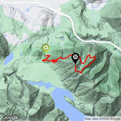
Roadway: The route starts on the wide, smooth gravel of the Palouse to Cascades Trail (the old Iron Horse/John Wayne Pioneer Trail rail bed), which is comfortable on any gravel bike. Past the Homestead Valley/Twin Falls area, it turns onto the much rougher Mount Washington Trail - a narrow, rocky, sometimes loose singletrack more characteristic of a mountain bike trail than a gravel road, with sections steep and technical enough that most riders will end up walking parts of it. The trail junction is marked informally, with small stone cairns and an old hand-carved tree mark rather than signage, so route-finding takes some attention.
Traffic: There's no vehicle traffic once you're on the trail system - just other cyclists, hikers, and trail runners. The Palouse to Cascades Trail can be busy with recreational users near the Rattlesnake Lake trailhead, especially on weekends.
Parking: Park at the Rattlesnake Lake trailhead near North Bend, which has a large lot and serves as the main access point for the Palouse to Cascades Trail. A Discover Pass is required for parking at Washington state recreation sites, including this one.
This climb rewards a mountain bike or a rugged gravel bike with wide, knobby tires - the loose, rocky Mount Washington Trail section isn't friendly to narrow tires or a road-oriented gravel setup.
Bring all your own water and food; there's nothing available on the route itself. North Bend, about 10 minutes from the trailhead, has full services including grocery stores, restaurants, and bike shops. A Discover Pass is required for parking.
Because the upper trail is loose and exposed in places, some riders may want to walk the bike through the steepest, most technical sections rather than force a ride.
Before heading out on any cycling adventure check out our Things to Bring on a Cycling Trip and use our interactive check list to ensure you don't forget anything.
North Bend and Snoqualmie, both a short drive from the Rattlesnake Lake trailhead, make an easy base, with the classic Snoqualmie Falls a worthwhile stop along the way.
Because the Mount Washington Trail holds snow into late spring and dries into loose, rocky terrain by summer, mid-to-late summer tends to offer the best traction and the clearest views of Mount Rainier from the summit.
If you want to extend the ride, the flat Palouse to Cascades Trail continues for miles in both directions, and our Routes in the Area tool is a good way to see what else is nearby in the Snoqualmie Valley.
ROUTE MAP
MEMBER RATING
CURRENT WEATHER
PJAMM TRIPS ADVENTURE STARTER BUNDLES
Check out PJAMM Adventure's prepackaged (self-guided) cycling trips. They will help you plan, document and conquer your next adventure.
NEARBY CLIMBS (0) RADIAL PROXIMITY
FROM No Climbs Found
MEMBER REVIEWS & COMMENTS
Let us know what you thought of this climb. Signup for our FREE membership to write a review or post a comment.
Already have an account?
LOG IN HERE
