
29.3
PDI
26 mi
DISTANCE
6,354 ft
GAINED
3.7 %
AVG. GRADE
FULL CLIMB STATS
Page Contributor(s): Michael Foster, Goleta, California
INTRO
Big Pine Mountain caps the San Rafael Mountains at 6,803+ feet, the highest point in both Santa Barbara County and the Dick Smith Wilderness. This climb reaches it the hard way: almost 26 miles and roughly 6,350 feet of gain up Camuesa Road and Buckhorn Road (Forest Route 9N11), starting from Upper Oso Campground north of Santa Barbara and climbing almost entirely on dirt and gravel.
It's an extension of the shorter Buckhorn Road gravel climb - keep going past the Little Pine Spring turnoff and the road gets progressively more remote, running along the narrow travel corridor that separates the San Rafael Wilderness to the south from the Dick Smith Wilderness to the north.
Bikes are legal on the roadbed itself even though the surrounding backcountry on both sides is federally designated Wilderness. Traffic is minimal to nonexistent, water and shade are scarce, and the payoff is a genuine backcountry summit that few road or gravel cyclists in Southern California ever see up close.
The 2007 Zaca Fire burned through this area and reshaped much of the surrounding chaparral and forest; nearly two decades later the road itself is well vegetated again but still takes a beating from winter storms - as of early 2026 the U.S. Forest Service lists Buckhorn Road as closed to motorized use for storm-damage repairs, which if anything makes for an even quieter ride, though it's worth confirming current conditions before committing to the full 26 miles out.
PLAN YOUR ROUTE
 We've partnered with Sherpa-Map.com to bring you the best route planning tool. With a PRO Membership you can use this climb as a reference when creating your route.
 At 3.67% average over nearly 26 miles, this is a long steady grind rather than a series of steep pitches - there's no single brutal ramp, just mile after mile of sustained gravel climbing that gains almost 6,350 feet from Upper Oso Campground (about 1,275 feet) to the summit area of Big Pine Mountain (6,800+ feet).
Expect short steeper rollers mixed into the overall grade, particularly in the first several miles out of Upper Oso, before the road settles into its long-haul rhythm through the middle and upper sections.
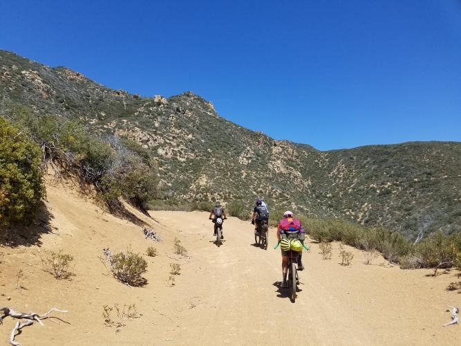
Roadway: Paved for the first short stretch out of Upper Oso, then dirt and gravel the rest of the way on Camuesa Road and Buckhorn Road (Forest Route 9N11). Surface quality varies with recent grading and weather - expect washboard, loose sections, and, after storms, real damage: the Forest Service's own before/after photos of this road show sections where high water has undercut the road shoulder. Wide gravel tires are a must; this isn't a road-bike surface.
Traffic: Very light to nonexistent. This is a remote Forest Service road serving the boundary between the San Rafael and Dick Smith Wilderness areas, and as of early 2026 it's officially closed to motorized use for storm-damage recovery - good news for cyclists, but confirm current status with the Santa Barbara Ranger District before riding, since a closure serious enough to keep vehicles out can also mean an unrepaired washout on the road itself.
Parking: Upper Oso Campground day-use lot, reached via Paradise Road off Highway 154. The lot is paved and charges a $10/day fee (cash or Parks Management Company pass); there's no dedicated trailhead parking beyond it, so this is where nearly everyone starts.
This is a gravel bike climb, not a road bike one - the surface is dirt and gravel almost the entire way, so wide tires (40mm or more) and a bike built to handle washboard and occasional rutting will make for a far better day than anything road-oriented.
Carry more water than you think you'll need: there's no reliable water source once you leave Upper Oso, and the lower miles in particular can bake in full sun with little shade. Dress in layers - it's typically hot and exposed down low, and noticeably cooler in the pines and at elevation near the summit.
Given how remote this road is, a spare tube or two, a real repair kit, and a way to call for help matter more here than on almost any other PJAMM climb in the region.
Before heading out on any cycling adventure check out our Things to Bring on a Cycling Trip and use our interactive check list to ensure you don't forget anything.
Santa Barbara, about 20 miles south, has every service a rider could need - lodging, bike shops, groceries - and Paradise Road off Highway 154 is the easiest way in from town.
The Upper Oso day-use lot charges a $10/day parking fee (cash or a Parks Management Company annual pass); there's no potable water or restroom service at the trailhead itself, so fuel up before leaving town.
Because Buckhorn Road serves such a remote stretch of the Los Padres National Forest, check current Forest Service alerts before heading out - the road has been subject to storm-damage closures to motorized traffic recently, and conditions on a dirt road this exposed to winter weather can change quickly.
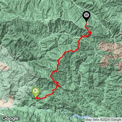
ROUTE MAP
MEMBER RATING
CURRENT WEATHER
PJAMM TRIPS ADVENTURE STARTER BUNDLES
Check out PJAMM Adventure's prepackaged (self-guided) cycling trips. They will help you plan, document and conquer your next adventure.
NEARBY CLIMBS (0) RADIAL PROXIMITY
FROM No Climbs Found
MEMBER REVIEWS & COMMENTS
Let us know what you thought of this climb. Signup for our FREE membership to write a review or post a comment.
Already have an account?
LOG IN HERE
