19.3
PDI
7.8 mi
DISTANCE
3,018 ft
GAINED
7.3 %
AVG. GRADE
FULL CLIMB STATS
INTRO
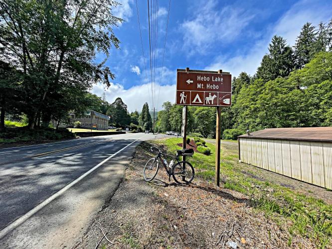
This 7.8 mile bike climb is located in OR, USA. The average gradient is 7.3% and there is a total elevation gain of 3,018 ft, finishing at 3,068 ft.
Use the profile tool, route map, and weather forecast to conquer this cycling climb.
Use the profile tool, route map, and weather forecast to conquer this cycling climb.
PLAN YOUR ROUTE
See more details and tools regarding this climb's grade via our interactive Profile Tool.
Information Not Available
If you have any information regarding this climb, we'd like to hear from you. Click the CONTRIBUTE button to share your thoughts with us.
Information Not Available
If you have any information regarding this climb, we'd like to hear from you. Click the CONTRIBUTE button to share your thoughts with us.
Before heading out on any cycling adventure check out our Things to Bring on a Cycling Trip and use our interactive check list to ensure you don't forget anything.
Information Not Available
If you have any information regarding this climb, we'd like to hear from you. Click the CONTRIBUTE button to share your thoughts with us.
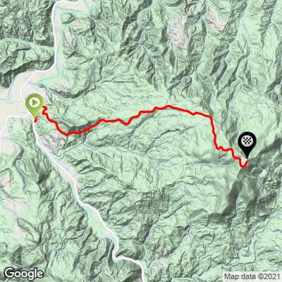
ROUTE MAP
MEMBER RATING
CURRENT WEATHER
PJAMM TRIPS ADVENTURE STARTER BUNDLES
Check out PJAMM Adventure's prepackaged (self-guided) cycling trips. They will help you plan, document and conquer your next adventure.
NEARBY CLIMBS (0) RADIAL PROXIMITY
FROM No Climbs Found
MEMBER REVIEWS & COMMENTS
Let us know what you thought of this climb. Signup for our FREE membership to write a review or post a comment.
Already have an account?
LOG IN HERE
josephbcoolman
I've climbed Mt. Hebo twice. It's a must do if you're in the area. Ample parking at the nearby rangers station. The road is a very low traffic climb. You may encounter logging trucks, the drivers are nice. Take care when descending, the road can be very slick from rain or fog. And it's a little broken up in a few spots. I always climb Hebo when I visit Lincoln City.
mikekeating
Almost no traffic on Hebo Road, but if you bike to Hebo Road, the surrounding roads have traffic and not much for shoulders. The roads are not bad, but a little rough. As I neared the peak of Hebo where the asphalt ends, I spotted something shiny in the road .... it was a shiny Delaware quarter in the center of the road. While I was living in Idaho at the time, I am from Delaware ... so I am not sure what to make of that! It's worth climbing and if I lived nearby it would be a great regular ride, but there was nothing spectacular that would make me want to climb it again. I only hit it because I was nearby visiting.