
23.9
PDI
10.7 mi
DISTANCE
3,839 ft
GAINED
6.5 %
AVG. GRADE
FULL CLIMB STATS
Page Contributor(s): Graham Johnson, San Diego, CA
INTRO
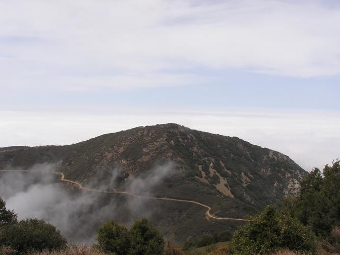
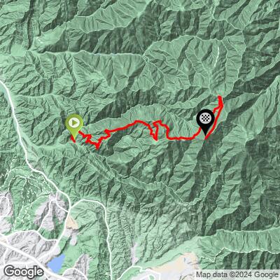
Harding Truck Trail is one of Orange County's classic dirt/gravel climbs, running 10.65 miles up the western face of the Santa Ana Mountains from Silverado Canyon toward the Modjeska Peak - Santiago Peak saddle, gaining 3,839 feet at a 6.5% average grade. The first mile kicks up close to 10%, then the grade settles into a long, grinding high-single-digit pull with almost no flat relief for most of the climb, easing only in the final mile.
The road is wide, exposed fire-road double-track deep inside Cleveland National Forest with few signs of the outside world - a legitimately remote-feeling ride for how close it sits to suburban Orange County.
Important: as of August 2026, this climb is closed to the public.
The September 2024 Airport Fire burned much of the surrounding Trabuco Ranger District, and the U.S. Forest Service's current closure order (No. 02-26-09) - which explicitly lists Harding Road (5S08) among the closed routes - remains in effect through May 26, 2027. Although many cyclists are still riding it, check the Cleveland National Forest website for the latest status before planning a trip here.
PLAN YOUR ROUTE
 We've partnered with Sherpa-Map.com to bring you the best route planning tool. With a PRO Membership you can use this climb as a reference when creating your route.
 The climb gains 3,839 feet over 10.65 miles at a 6.5% average grade, finishing around 5,025 feet. The first mile is the steepest test on the climb, running close to 10%, before the grade settles into a sustained high-single-digit grind for most of the remaining distance.
There's very little flat ground to recover on until the final mile, which eases off noticeably as the road approaches the Modjeska Peak - Santiago Peak saddle.
Roadway: Harding Truck Trail is a genuine dirt/gravel fire road, not a paved surface with occasional gravel - wide, hard-packed double-track for the first several miles that holds up reasonably well in wet weather, aside from some looser sections near the bottom. It's officially Forest Road 5S08 within Cleveland National Forest.
Traffic: As of August 2026, this entire route is closed to the public. The September 2024 Airport Fire burned a large area of the Trabuco Ranger District, and the Forest Service's current closure order (No. 02-26-09, in effect through May 26, 2027) explicitly lists Harding Road (5S08) among the closed roads within the burn perimeter. Do not attempt this climb until the Forest Service lifts the closure - check the Cleveland National Forest website or call the Supervisor's Office (858-673-6180) for the latest status. When open, traffic is otherwise light: occasional Forest Service vehicles, hikers, and mountain bikers, with no through vehicle traffic since the road dead-ends at the ridge.
Parking: There's no formal trailhead lot - riders typically park along Silverado Canyon Road near where Harding Truck Trail begins. A Forest Adventure Pass is required to park within Cleveland National Forest boundaries.
There's no water or services anywhere on the climb - the last opportunities to fill up are in Silverado or Modjeska Canyon at the base, so carry everything you'll need for several hours of exposed, high-desert riding. A gravel bike with sturdy, wider tires is the right call given the looser sections near the bottom and the general fire-road surface throughout.
This part of the Santa Ana Mountains gets genuinely hot in summer and can see fast-moving weather changes, so check conditions and fire-danger status before heading out, and carry a way to call for help - cell coverage is inconsistent once you're deep in the forest.
Before heading out on any cycling adventure check out our Things to Bring on a Cycling Trip and use our interactive check list to ensure you don't forget anything.
Orange County's usual base towns - Silverado, Trabuco Canyon, and greater Orange County - have all the hotels, food, and bike shops you'd need; this climb sits about 45 minutes from central Orange County and under an hour from most LA-area starting points.
A Forest Adventure Pass ($5/day or $30/year) is required to park within Cleveland National Forest.
Before planning a trip, confirm this climb has reopened - it currently falls within the Cleveland National Forest's Airport Fire closure area, in effect through May 26, 2027 as of this writing.
If you're looking for other options nearby while this one is closed, our Routes in the Area tool can show what else is rideable around Orange County.
ROUTE MAP
MEMBER RATING
CURRENT WEATHER
PJAMM TRIPS ADVENTURE STARTER BUNDLES
Check out PJAMM Adventure's prepackaged (self-guided) cycling trips. They will help you plan, document and conquer your next adventure.
NEARBY CLIMBS (0) RADIAL PROXIMITY
FROM No Climbs Found
MEMBER REVIEWS & COMMENTS
Let us know what you thought of this climb. Signup for our FREE membership to write a review or post a comment.
Already have an account?
LOG IN HERE
