
28
PDI
6.7 mi
DISTANCE
3,157 ft
GAINED
8.8 %
AVG. GRADE
FULL CLIMB STATS
Page Contributor(s): Tanner Jacobs, Davis, West Virginia
INTRO
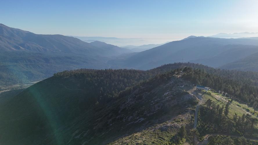
Radford Truck Trail (Forest Road 2N06) is a rugged doubletrack climb in the San Bernardino National Forest, gaining about 3,157 feet over 6.7 miles (8.8% grade) as it winds up the Converse Creek drainage on the south flank of Snow Summit, above Big Bear Lake. Most riders treat it as an out-and-back, though the top connects into the Skyline Trail network along the ridge.
The surface is loose, rocky, and genuinely chunky - not a smooth gravel grind. Riders who've done it describe rockfall, occasional downed timber, and rough, technical pitches near the top, and generally recommend a hardtail mountain bike with plus-size tires over a typical drop-bar gravel rig (see Gear & Provisions below for a detailed firsthand tire and pressure setup).It's occasionally used for off-road endurance events and can be ridden in either direction, though nearly everyone tackles it as a climb from the south.
As of 2026, Radford Truck Trail is technically closed to all public entry - however, many cyclists have still been riding it, including dozens of Strava attempts this summer. The 2022 Radford Fire triggered a USFS forest order closing Forest Road 2N06 along with 2N10, 2N10D, and 2N21, plus the connecting Skyline, Pirates, and Fall Line trails. The order runs through the end of 2026.
Check the San Bernardino National Forest's Radford Fire Closure Area alert page, or call the Mountaintop Ranger District at 909-382-2790, before planning a trip.
Check the San Bernardino National Forest's Radford Fire Closure Area alert page, or call the Mountaintop Ranger District at 909-382-2790, before planning a trip.
PLAN YOUR ROUTE
 We've partnered with Sherpa-Map.com to bring you the best route planning tool. With a PRO Membership you can use this climb as a reference when creating your route.
 Radford Truck Trail climbs at an 8.8% average grade over 6.7 miles (3,157 ft of gain), from about 5,346' near the old Converse Station up to roughly 8,454' near the ridge below Snow Summit. It's a steady, grinding climb rather than a series of brutal ramps - riders describe the gradient as consistent, with the loose, technical surface doing more to slow you down than the pitch itself. Expect the grade to stiffen somewhat in the upper third as the road approaches the ridge near Skyline Trail.
See more details and tools regarding this climb's grade via the "Profile Tool" button.
Roadway: Loose, rocky doubletrack - genuinely chunky, not a groomed gravel road. Expect embedded rock, washboard, and occasional rockfall or downed timber since the road isn't regularly graded; riders recommend a hardtail mountain bike or a rigid gravel bike with wide (44mm+) tubeless tires.
Traffic: Minimal to none - this is a forest road popular with off-road vehicles and mountain bikers when open, not a through-route for cars.
Access: Currently closed. The 2022 Radford Fire triggered an active USFS closure (Forest Order No. 05-12-52-24-06) covering Forest Road 2N06 and several connecting roads and trails, in effect through December 31, 2026. Entering the closure area is a federal violation punishable by fines up to $5,000. Confirm current status with the Mountaintop Ranger District (909-382-2790) before riding.
Parking: When accessible, riders park near the former Converse Station off Highway 38; a National Forest Adventure Pass is required to park in the San Bernardino National Forest.
Tanner Jacobs: It's pretty chunky. I was running 38 front / 35 rear w/ CushCore tires at 8-10 psi. The ideal rig would be a hardtail mtb with plus size tires. I think you could skimp by with a rigid fork bike that has 700/650x44 tubeless tires - just know that it'll be work. I was also carrying bikepacking gear, had carbon-soled clipless cleats, and a poor gear ratio for this kinda riding. Otherwise, it was an awesome area to ride and I'd love to go back w/ the right bike someday!
No services along the climb itself - stock up in Angelus Oaks or Big Bear Lake beforehand, and carry a real repair kit; this is remote, rocky terrain where a flat or mechanical means a long walk out.
Before heading out on any cycling adventure check out our Things to Bring on a Cycling Trip and use our interactive check list to ensure you don't forget anything.
Radford Truck Trail sits between Angelus Oaks and Big Bear Lake along Highway 38 in the San Bernardino Mountains, roughly two hours east of Los Angeles. A National Forest Adventure Pass is required to park anywhere in the San Bernardino National Forest, available at ranger stations and many local vendors.
If you're planning a trip, note that the road is currently inside the Radford Fire closure area (see Roadway & Parking) - call the Mountaintop Ranger District at 909-382-2790 to confirm it has reopened before you go. Once accessible again, it pairs well with other Big Bear-area climbs given the short drive between them.
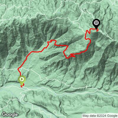
ROUTE MAP
MEMBER RATING
CURRENT WEATHER
PJAMM TRIPS ADVENTURE STARTER BUNDLES
Check out PJAMM Adventure's prepackaged (self-guided) cycling trips. They will help you plan, document and conquer your next adventure.
NEARBY CLIMBS (0) RADIAL PROXIMITY
FROM No Climbs Found
MEMBER REVIEWS & COMMENTS
Let us know what you thought of this climb. Signup for our FREE membership to write a review or post a comment.
Already have an account?
LOG IN HERE
