
32.6
PDI
14.1 mi
DISTANCE
5,010 ft
GAINED
6.7 %
AVG. GRADE
FULL CLIMB STATS
Page Contributor(s): Nathan Manwaring, Mountain Green, Utah
INTRO
Titus Canyon Road West climbs the lower, canyon half of Death Valley National Park's most famous backcountry road - a 27-mile, one-way dirt route that normally carries vehicle traffic downhill from Nevada Highway 374, through the Grapevine Mountains, and out through Titus Canyon's narrows to the valley floor.
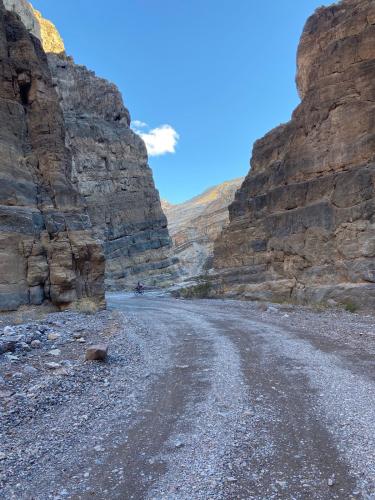
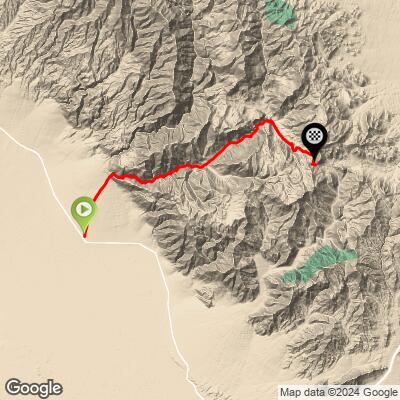
This climb rides that final stretch in reverse: starting at the canyon's west mouth and gaining 5,010 feet over 14.1 miles, up through the narrows, past the petroglyphs at Klare Spring and the Leadfield ghost town turnoff, to Red Pass (5,250 ft), the high point of the entire road. The narrows are the highlight. Limestone walls fold and squeeze to less than 20 feet apart in places, with the road ducking in and out of the wash beneath them.
Per the National Park Service, Titus Canyon is the most popular backcountry drive in Death Valley, so don't expect solitude - and since the road is normally driven one-way from east to west, riding it as a climb means pedaling into oncoming vehicle traffic through a canyon with blind corners.
The road has been closed for extended stretches since flood damage from a 2022 storm, including a period when bicycles were explicitly barred from the canyon alongside the vehicle closure.
It has reopened temporarily as of this update after an initial repair phase, but NPS notes it may still close on short notice. A second, longer closure is already scheduled for October 1, 2026 through September 30, 2027 - check conditions before you go.
PLAN YOUR ROUTE
 We've partnered with Sherpa-Map.com to bring you the best route planning tool. With a PRO Membership you can use this climb as a reference when creating your route.
 This is a genuinely uneven climb rather than a steady grind. The steepest quarter mile averages 10.4%, easing to 9.6% over a half mile, 8.8% over a full mile, and 7.75% over 2.5 miles, with the whole 14.1-mile climb averaging 6.7%. Expect the harder pitches mixed in through the narrows and on the approach to Red Pass, with gentler graded sections nearer the canyon mouth.
Roadway: Titus Canyon Road is unpaved for its entire length - a graded dirt road near the canyon mouth that gets rougher, narrower, and sandier as it climbs into the narrows. High-clearance vehicles are recommended for the road overall; the section this climb covers, at the west end, is the graded two-way portion. Expect washboard, loose rock, and a few sandy patches - 40-45c+ tires are worth having.
Traffic: This is the most popular backcountry road in Death Valley National Park, per the NPS, and it's normally driven one-way from east to west by motor vehicles - meaning a cyclist climbing this direction is riding into oncoming traffic through a canyon with blind corners and no shoulder. Ride early on a weekday if you can, and stay alert through the narrows.
Parking: Park at the dirt pullout at the canyon's west mouth, reached via the two-way stretch of Titus Canyon Road off Scotty's Castle Road. No facilities on site.
Bring more water than you think you'll need - there's no water source anywhere on this climb, and Death Valley heat is extreme outside the cooler months (roughly November through March is the realistic riding window). A gravel bike with 40-45c+ tires handles the sandy and washboard sections comfortably; a tubeless setup helps on the rockier stretches near the narrows. Carry a real repair kit and a way to call for help - cell coverage is unreliable this deep in the canyon, and it's a long way from assistance in either direction.
Before heading out on any cycling adventure check out our Things to Bring on a Cycling Trip and use our interactive check list to ensure you don't forget anything.
Furnace Creek, with the park's main services and campground, is about 33 miles south via Scotty's Castle Road and CA-190. Beatty, Nevada sits just outside the park's east boundary near Titus Canyon Road's other end, and makes a good staging point if you're combining this with a ride through the full canyon.
Many visitors stop at the Rhyolite ghost town, just outside Beatty, before or after a Titus Canyon trip. Because this road is on an active repair schedule, check the NPS's Death Valley alerts page (nps.gov/deva/planyourvisit/conditions.htm) before you drive out - and note it's due to close again for a second phase of repairs from October 1, 2026 through September 30, 2027.
ROUTE MAP
MEMBER RATING
CURRENT WEATHER
PJAMM TRIPS ADVENTURE STARTER BUNDLES
Check out PJAMM Adventure's prepackaged (self-guided) cycling trips. They will help you plan, document and conquer your next adventure.
NEARBY CLIMBS (0) RADIAL PROXIMITY
FROM No Climbs Found
MEMBER REVIEWS & COMMENTS
Let us know what you thought of this climb. Signup for our FREE membership to write a review or post a comment.
Already have an account?
LOG IN HERE
