
28.6
PDI
22.4 mi
DISTANCE
5,307 ft
GAINED
4.5 %
AVG. GRADE
FULL CLIMB STATS
Page Contributor(s): Ice Violet, Newport, OR; Ron Barrett (photo); James J, Bend, OR; Jordan Sherman, Golden, CO
INTRO
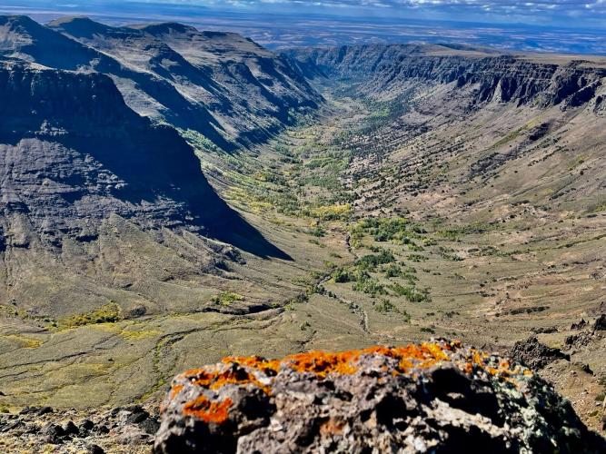
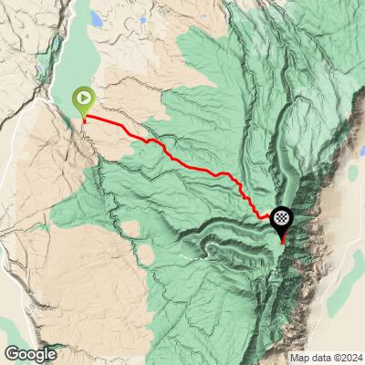
Steens Mountain Road West climbs 22.4 miles and 5,307 ft from the high desert near Frenchglen up the Steens Mountain Loop Road - the Bureau of Land Management's gravel route across Steens Mountain, one of the largest fault-block mountains in the country - finishing near 9,541 ft, within a few hundred feet of the East Rim Overlook and the highest vehicle-accessible ground in Oregon.
The road climbs from sagebrush high desert past Fish Lake and Jackman Park into sub-alpine terrain, with aspen groves that turn gold in early fall before the route opens onto sweeping views east across the Alvord Desert from the rim. It's remote, exposed, and entirely seasonal - the BLM gates the road each winter under heavy snow, generally reopening in stages from late spring and staying open into October or November depending on the year; check the BLM Burns District's current conditions before planning a trip.
PJAMM contributors who've ridden it are consistent that it's manageable on a gravel bike:
Ice Violet - "Steens loop road is totally rideable on gravel bike! You top out at the East Rim Overlook, looking down the E escarpment. Spectacular. Then descending towards Frenchglen, watch for Cold Springs road (left, signed). Beautiful descending through aspen groves. Much more fun on Mtn bike, safer too. There's always water at cold springs, you know it by the cabin and the porcelain bathtub. Below this you'll have to proceed with caution if on gravel bike, but on mtb one can fly downhill. Eventually you'll reach a locked gate but it's legal to ride your bike on the faint 2 track through the grassland to Riddle Bros Ranch (BLM historical property open to public). From RBR it's easy fine gravel back to south Steens CG."
James J - "It is rideable by gravel bike and the road surface is usually about a 2-3 on a 1 smooth to 5 very rough scale, depending on if they've graded it recently. Certainly some washboard."
Jordan Sherman - "I did this climb on a gravel (CX) bike. Road surface is fairly smooth 1-2 for the ascent but the descent was more loose, but so much fun and insane views. I highly recommend this route."
PLAN YOUR ROUTE
 We've partnered with Sherpa-Map.com to bring you the best route planning tool. With a PRO Membership you can use this climb as a reference when creating your route.
 Steens Mountain Road West averages a modest 4.49% over its full 22.4 miles, but that number flattens out a genuinely uneven profile - contributors James J and Jordan Sherman both describe the ascent as comparatively smooth and steady, while short pitches in the middle and upper sections push well past the average as the road works up through the high desert toward the East Rim. Expect the effort to come more from sustained length and altitude (the finish sits near 9,541 ft) than from any single brutal pitch.
Roadway: Steens Mountain Loop Road is graded gravel, generally rideable on a standard gravel bike with wider tires. Contributors rate the surface a 1-3 out of 5 on a smooth-to-rough scale depending on how recently the BLM has graded it, with washboard sections common; expect it to firm up on the ascent and loosen on faster descents. The road is passable by standard 2WD vehicles in good conditions, though high clearance is worth having, especially near the steeper, rockier sections.
Traffic: Very light - this is a remote BLM backcountry road through the Steens Mountain Cooperative Management and Protection Area, with occasional vehicle and ranch traffic but nothing resembling regular through-traffic. The road is entirely seasonal: snow closes it every winter, and the BLM's four gates reopen in stages through late spring as snow clears, typically running fully open from around July through mid-fall. Confirm current conditions with the BLM Burns District office (541-573-4400) or Oregon's TripCheck before heading out, since a late-spring or early-winter trip risks a locked gate.
Parking: Stage from Frenchglen, the small unincorporated community at the western base of the mountain along OR-205, where the loop road begins; it has basic services (the historic Frenchglen Hotel, a small store) but nothing beyond that, so come prepared for a remote, multi-hour effort with no support along the climb itself.
A gravel bike with wide tires (40mm+) is the right tool here, per every contributor who's weighed in - Ice Violet specifically found it "much more fun on Mtn bike, safer too" for the descent, since the road turns looser and rockier below the rim.
Carry more water than you think you'll need; aside from a spring at Cold Springs partway down the far side (marked by an old cabin and a distinctive porcelain bathtub, per Ice Violet), there's nothing reliable along the route.
Pack layers - conditions at 9,500+ ft can be cold and windy even when it's hot in the valley below.
Before heading out on any cycling adventure check out our Things to Bring on a Cycling Trip and use our interactive check list to ensure you don't forget anything.
Frenchglen, at the base of the loop road on OR-205, is the practical staging point - it has the historic Frenchglen Hotel and a small store, but little else, so stock up in Burns (about 60 miles north) beforehand. Plan your trip for summer through early fall; the road is snowbound and gated the rest of the year, and conditions can still be cold and exposed even in July at elevation.
For recreation information, maps, or current road status, contact the BLM's Burns District office in Hines (541-573-4400) or check Oregon's TripCheck. If you're up for more than an out-and-back, the full Steens Mountain Loop Road continues past the East Rim down the mountain's south side toward South Steens Campground and Riddle Brothers Ranch, a historic BLM property open to visitors.
ROUTE MAP
MEMBER RATING
CURRENT WEATHER
PJAMM TRIPS ADVENTURE STARTER BUNDLES
Check out PJAMM Adventure's prepackaged (self-guided) cycling trips. They will help you plan, document and conquer your next adventure.
NEARBY CLIMBS (0) RADIAL PROXIMITY
FROM No Climbs Found
MEMBER REVIEWS & COMMENTS
Let us know what you thought of this climb. Signup for our FREE membership to write a review or post a comment.
Already have an account?
LOG IN HERE
