
23.4
PDI
9.8 mi
DISTANCE
3,572 ft
GAINED
6.9 %
AVG. GRADE
FULL CLIMB STATS
INTRO
PLAN YOUR ROUTE
 We've partnered with Sherpa-Map.com to bring you the best route planning tool. With a PRO Membership you can use this climb as a reference when creating your route.
 This climb gains 3,572 feet in 9.8 miles for a 6.92% average grade, moderate on paper but uneven in practice rather than steady. The steepest 100 yards hits 14.65%, the steepest quarter-mile 13.38%, and the steepest mile still averages 11.36%, while the broader 2.5-mile and 5-mile averages ease back to 8.44% and 7.79%. Expect short, punchy pitches broken up by mellower stretches, rather than one constant grade all the way to the pass at 6,190 feet.
Roadway: The lower miles of Harts Pass Road are paved, but the climb transitions to graded dirt and gravel for its final stretch to the pass - narrow, washboarded in places, and exposed on the outside edge of several corners with no guardrails. A gravel or mountain bike with wider tires handles it far better than a standard road bike.
Traffic: Traffic is light but not absent - RVs, trucks with trailers, and Pacific Crest Trail hikers being shuttled to and from the trailhead all use this same narrow road, so give blind corners extra room. 2026 has been an unusually disrupted season here: winter storm damage closed the road for months into early summer, and as of late August 2026 a reduced but still-active wildfire closure order (Ptarmigan Fire) affects parts of the surrounding Pasayten Wilderness, including trailheads at and beyond Harts Pass. Check the Okanogan-Wenatchee National Forest's current alerts or call the Methow Valley Ranger District (509-996-4000) before riding, especially if you plan to continue past the pass.
Parking: There's no formal cyclist trailhead partway up; most riders start from Mazama, where there's roadside parking near the highway junction, or from a pullout further up the road if driving partway to shorten the ride. Harts Pass itself has a small parking area near the Pacific Crest Trail crossing.
This is a remote, high-alpine climb with zero services along the way, so carry everything you need: full water (there's nowhere to refill after leaving Mazama), food, a real repair kit, and warm layers even in summer, since temperatures above 6,000 feet can be dramatically colder and windier than the valley floor.
A gravel or mountain bike with wide tires and low gearing is the right choice for the unpaved upper miles. Cell service is unreliable to nonexistent once you're on the mountain, so let someone know your plan before you go.
Before heading out on any cycling adventure check out our Things to Bring on a Cycling Trip and use our interactive check list to ensure you don't forget anything.
Mazama, at the base of the climb, has a general store, a bakery, and a handful of lodging options, but it's genuinely small; Winthrop, about 15 miles east, has a fuller range of restaurants, bike shops, and places to stay if you want a bigger base for a Methow Valley cycling trip.
The climbing season here is short, reliably open from early July through early October depending on snowpack, and 2026 has added wildfire and storm-damage closures on top of the usual seasonal window, so check current conditions before committing to the drive out.
If you're spending a few days in the valley, our Routes in the Area tool is worth a look for other Methow-area climbs to pair with this one.
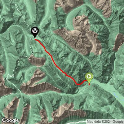
ROUTE MAP
MEMBER RATING
CURRENT WEATHER
PJAMM TRIPS ADVENTURE STARTER BUNDLES
Check out PJAMM Adventure's prepackaged (self-guided) cycling trips. They will help you plan, document and conquer your next adventure.
NEARBY CLIMBS (0) RADIAL PROXIMITY
FROM No Climbs Found
MEMBER REVIEWS & COMMENTS
Let us know what you thought of this climb. Signup for our FREE membership to write a review or post a comment.
Already have an account?
LOG IN HERE
Nelg69
I road it on 7/2/24 on my gravel bike. It is a beautiful climb with fantastic views and is shaded in parts. The road is gravel with most of it washboard, choppy in sections and rocky. The road makes the climb harder than the Fiets would indicate. At least a gravel bike is needed. The descent is not fun as it rattles your brain.
