20.8
PDI
11.7 mi
DISTANCE
3,568 ft
GAINED
5.8 %
AVG. GRADE
FULL CLIMB STATS
INTRO
This 11.7 mile bike climb is located in WA, USA. The average gradient is 5.8% and there is a total elevation gain of 3,568 ft, finishing at 6,455 ft.
Use the profile tool, route map, and weather forecast to conquer this cycling climb.
Use the profile tool, route map, and weather forecast to conquer this cycling climb.
PLAN YOUR ROUTE
This climb averages 0%. The steepest quarter mile of this climb is 0%. NaN miles of the climb is at or above 10% grade. The gradient on this climb is broken down as follows:
See more details and tools regarding this climb's grade via our interactive Profile Tool.
See more details and tools regarding this climb's grade via our interactive Profile Tool.
Information Not Available
If you have any information regarding this climb, we'd like to hear from you. Click the CONTRIBUTE button to share your thoughts with us.
Information Not Available
If you have any information regarding this climb, we'd like to hear from you. Click the CONTRIBUTE button to share your thoughts with us.
Before heading out on any cycling adventure check out our Things to Bring on a Cycling Trip and use our interactive check list to ensure you don't forget anything.
Information Not Available
If you have any information regarding this climb, we'd like to hear from you. Click the CONTRIBUTE button to share your thoughts with us.
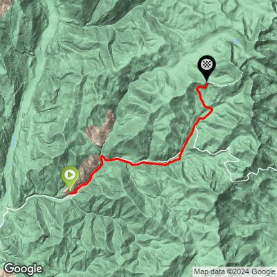
ROUTE MAP
MEMBER RATING
CURRENT WEATHER
PJAMM TRIPS ADVENTURE STARTER BUNDLES
Check out PJAMM Adventure's prepackaged (self-guided) cycling trips. They will help you plan, document and conquer your next adventure.
NEARBY CLIMBS (0) RADIAL PROXIMITY
FROM No Climbs Found
MEMBER REVIEWS & COMMENTS
Let us know what you thought of this climb. Signup for our FREE membership to write a review or post a comment.
Already have an account?
LOG IN HERE
MethowBiker
From the bridge over the chewuch river, the first 7 miles is paved, sort of. Lots of forest fires and lack of maintenance make a gravel bike a necessity even on this lower section. Pavement ends at around 3200 feet. From there to 5,000 feet, a good mile plus of heavy washboard. The last couple miles to the pass are very rough, but fine in my 44 mm tires. Great views, esp now since much as the country there has burned since 2014. Zero services, little to no cell service. Take everything you need. Continue north for a nice bike packing route all the way to loomis and Orville. This is bear country too. Note that the weather here is MUCH different than Winthrop. I’ve seen snow squalls here in July.