
43.3
PDI
17.2 mi
DISTANCE
6,285 ft
GAINED
6.9 %
AVG. GRADE
FULL CLIMB STATS
Page Contributor(s): Don Baty, Corvallis, OR; Owen McDougal, Boise, ID
INTRO
This 17.2-mile gravel climb leaves Riggins, Idaho and follows Forest Road 517 - locally known as Seven Devils Road - up 6,285 feet to the Heavens Gate Overlook, an 8,429-foot viewpoint on the rim of Hells Canyon. PJAMM currently ranks it the 9th-hardest gravel climb in the world.
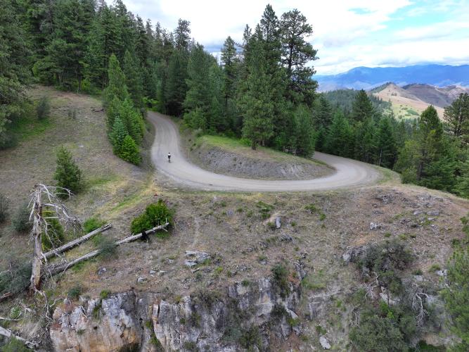
Pavement gives way to gravel and dirt within the first couple of miles, and the road narrows and steepens as it climbs past homes along Squaw and Papoose creeks into the Nez Perce-Clearwater National Forest.
Much of the upper road is single-lane, winding, and not recommended for RVs, trailers, or low-clearance vehicles. Near the top, the road passes Windy Saddle, the main trailhead for the Seven Devils hiking network, before the final push to the lookout.
Heavens Gate is considered the best view into Hells Canyon from the Idaho side. On a clear day, the fire lookout tower at the summit looks out over peaks in four states - Idaho, Oregon, Washington, and Montana. PJAMM contributor Owen McDougall calls it "a really great gravel bike ride" with amazing views and a reasonable grade once you're on dirt, recommending 40mm+ tires.
The road is only open seasonally, typically from late June through October depending on snowpack - check current Nez Perce-Clearwater National Forest conditions before heading out.
PLAN YOUR ROUTE
 We've partnered with Sherpa-Map.com to bring you the best route planning tool. With a PRO Membership you can use this climb as a reference when creating your route.
 Overall this climb averages a manageable 6.9% over 17.2 miles, but it's not a steady grind. The lower miles out of Riggins climb gently on pavement before the gravel starts, and grades pick up through the switchbacks past Squaw and Papoose creeks. The steepest, narrowest sections come in the upper miles as the road approaches Windy Saddle and the final climb to the Heavens Gate parking area, where the grade and the exposure both increase. Expect a long, mostly moderate grind with harder pitches concentrated in the final few miles.
Roadway: Forest Road 517 is paved for a short stretch out of Riggins, then gravel and dirt for the remaining 15-plus miles. The surface is generally well-graded lower down but narrows to a single lane with washboard and loose gravel higher up, especially near Windy Saddle and the final approach to the lookout. It's a steep, winding road not recommended for RVs, trailers, or low-clearance vehicles.
Traffic: Light. This is a dead-end forest road serving the lookout, a campground, and the Seven Devils trailhead system - expect weekend hikers, campers, and the occasional slow-moving truck or RV in the lower miles, with minimal traffic higher up.
Parking: Roadside parking is available near the US-95/Seven Devils Road junction just south of Riggins if you want to start from town, or you can drive partway up FR 517 and start higher. A parking lot sits near the Heavens Gate summit for the short half-mile trail up to the fire lookout tower.
A gravel bike with wide tires - 40mm or more - handles the mixed gravel and dirt surface well. Gearing that lets you spin comfortably on a long, steady climb is more important here than anything built for short punchy grades; the reward is a very reasonable ride once you're off pavement and onto dirt. Carry all the food and water you'll need, since there are no services anywhere along FR 517 - stock up in Riggins before you start. Because the road is only reliably open from late June through October depending on snowpack, check current conditions before making the drive or ride out.
Before heading out on any cycling adventure check out our Things to Bring on a Cycling Trip and use our interactive check list to ensure you don't forget anything.
Riggins, Idaho is a small Salmon River rafting town in Idaho County, about 100 miles south of Lewiston and roughly 3 hours north of Boise via US-95. It has gas, groceries, a handful of restaurants, and motels - a good place to fuel up and stay before or after the climb. There are no services along the climb itself. If you have extra time, the Seven Devils Mountains and Hells Canyon, the deepest river gorge in North America, are both right at the top of this route and worth building into a longer visit.
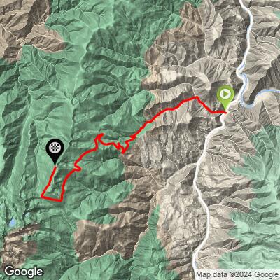
ROUTE MAP
MEMBER RATING
CURRENT WEATHER
PJAMM TRIPS ADVENTURE STARTER BUNDLES
Check out PJAMM Adventure's prepackaged (self-guided) cycling trips. They will help you plan, document and conquer your next adventure.
NEARBY CLIMBS (0) RADIAL PROXIMITY
FROM No Climbs Found
MEMBER REVIEWS & COMMENTS
Let us know what you thought of this climb. Signup for our FREE membership to write a review or post a comment.
Already have an account?
LOG IN HERE
