
31.9
PDI
7.2 mi
DISTANCE
3,697 ft
GAINED
9.7 %
AVG. GRADE
FULL CLIMB STATS
Page Contributor(s): Don Baty, Corvallis, OR; Jim Laudolff, Sammamish, WA
INTRO
Hess Road climbs 3,697 feet in just 7.24 miles above the Snake River in Hells Canyon, on the Oregon side of the Oregon-Idaho border in Baker County. Averaging 9.69%, with pitches over 15% and a steepest quarter-mile above 17%, it's one of the hardest gravel climbs in the state - we currently rank it 31st-hardest in our database.
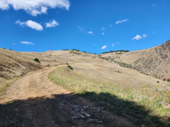
The climb anchors Dirty Freehub's "Hell of Hess" gravel loop, which reaches Hess Road's base via a rolling gravel road built on an old railroad grade along the Snake River. From there the road turns uphill in earnest, switchbacking up open, exposed slopes with sweeping views back down into the canyon before finally easing to a gentler 5-6% for the last couple of miles as it enters forest near the top.
PJAMM contributor Jim Laudolff, who rode it on a gravel bike, called it "hella steep" and said he walked a few short sections where he lost traction.
Hells Canyon is the deepest river gorge in North America - deeper than the Grand Canyon - carved by the Snake River over the last six million years. Oxbow, at the base of the climb, sits near the site of the old mining and railroad town of Copperfield, notorious enough that Oregon's governor imposed martial law there in 1914.
The gravel road up Hess Road is best ridden in the warmer months; the surrounding Hells Canyon Scenic Byway typically closes with the first heavy snow from late October until late May or June.
PLAN YOUR ROUTE
 We've partnered with Sherpa-Map.com to bring you the best route planning tool. With a PRO Membership you can use this climb as a reference when creating your route.
 Hess Road backs up its reputation with real numbers: 3,697 feet of gain over 7.24 miles for a 9.69% average, and the climb is far from steady. The steepest quarter-mile hits 17.8%, the steepest full mile averages 15.1%, and even the steepest 5-mile window - nearly the whole climb - still averages 11.4%. Pitches over 15% show up repeatedly on the switchbacks partway up, right where the exposed slopes offer the least shade.
The final two and a half miles are the exception: as Hess Road tops out and enters forest, the grade eases to a more forgiving 5-6%, a welcome change after the grind below. There's no flat or downhill stretch to recover on anywhere in between - once the gravel river road gives way to Hess Road itself, you're climbing until the top.
Roadway: Hess Road is unpaved for its entire length - a mix of gravel and hardpack dirt that firms up in dry summer conditions but can wash out or rut after rain. Expect loose gravel and washboard on the steeper switchbacked pitches; a gravel bike with 40mm-or-wider tires handles it far better than anything narrower. The final stretch to the top mellows onto a smoother forest road.
Traffic: This is a remote, sparsely traveled gravel road - mostly other cyclists, with occasional local traffic including ATVs, per PJAMM contributor Jim Laudolff, who noted seeing locals driving it. There's no shoulder and sightlines are limited on the switchbacks, so stay alert around blind corners.
Parking: There's no dedicated trailhead or lot at the base of Hess Road. Most riders park in Oxbow, about 6.5 miles south via the gravel river road, and ride in from there.
A gravel bike with wide tires - 40mm or more - is the right tool for Hess Road's mix of loose gravel, washboard, and hardpack dirt. PJAMM contributor Jim Laudolff rode it on 650b wheels with 50mm Cinturato gravel tires and low gearing (34x34), and still walked a couple of short pitches where he lost traction - budget for a very low gear given the sustained double-digit grades and 15%+ ramps.
There are no services anywhere on the climb itself, so carry all the food and water you'll need. Oxbow, at the base, has no reliable services either - stock up in Halfway, about 20 miles east on OR-86, before heading out.
Before heading out on any cycling adventure check out our Things to Bring on a Cycling Trip and use our interactive check list to ensure you don't forget anything.
Halfway, Oregon is the closest town with real services - gas, groceries, restaurants, and lodging - about 20 miles east of Oxbow on OR-86. It bills itself the gateway to Hells Canyon country; Cornucopia Coffee House and Rush Hour Pizza are both local favorites worth a stop before or after the ride. Oxbow itself, at the base of the climb, is little more than the Idaho Power complex and a scattering of homes - don't count on finding anything open there.
Hells Canyon Dam and the Hells Canyon Overlook on the Wallowa Mountain Loop Road (Forest Road 39) are both close enough to combine with the ride if you have extra time; the overlook sits near where Hess Road eventually connects to pavement.
The Hells Canyon Scenic Byway is subject to seasonal snow closures, typically reopening in late May or June and closing again by late October - check current conditions before planning a trip outside summer.
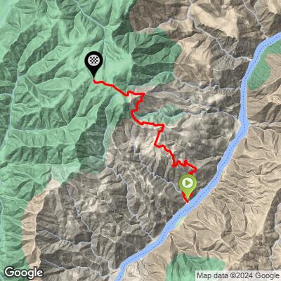
ROUTE MAP
MEMBER RATING
CURRENT WEATHER
PJAMM TRIPS ADVENTURE STARTER BUNDLES
Check out PJAMM Adventure's prepackaged (self-guided) cycling trips. They will help you plan, document and conquer your next adventure.
NEARBY CLIMBS (0) RADIAL PROXIMITY
FROM No Climbs Found
MEMBER REVIEWS & COMMENTS
Let us know what you thought of this climb. Signup for our FREE membership to write a review or post a comment.
Already have an account?
LOG IN HERE
