
33.3
PDI
17.4 mi
DISTANCE
5,454 ft
GAINED
5.9 %
AVG. GRADE
FULL CLIMB STATS
INTRO
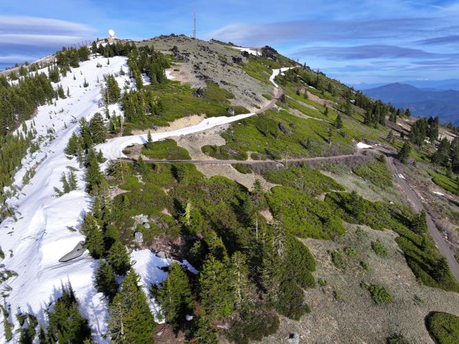
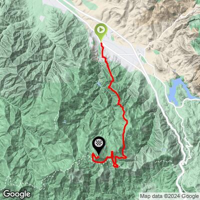
Mt. Ashland via NFR 2080 is a 17.4-mile, 5,454-foot gravel climb that starts right in Ashland, Oregon and finishes at 7,371 feet near the summit of Mt. Ashland. At an average grade of 5.9%, it's shorter but more consistently steep than its sister route up Wagner Creek Road, and it's ranked #26 in the world on PJAMM's difficulty index.
The route climbs Tolman Creek Road (Forest Road 2080) directly out of town and into the Ashland Watershed, passing near Bull Gap - a saddle that was part of the original "Mount Ashland Loop Road," built by the Civilian Conservation Corps in the 1930s and the only way up the mountain from Ashland until the modern highway was built decades later. Unlike the Wagner Creek Road route, this climb passes through the Mt. Ashland Ski Area on its way to the top, and shares the final, brutal 10.3%-average mile with the other two gravel routes up the mountain.
Because the road climbs almost the entire way - barely 30 feet of descent in over 17 miles - there's no coasting to recover; it's sustained work from the edge of Ashland to the summit. The Ashland Watershed road network sees regular Forest Service maintenance in summer - in 2026, crews were doing hazard-tree removal and road repair on the lower section this climb starts on (Forest Road 2060, before it becomes 2080), with scheduled weekday closures. Check current Rogue River-Siskiyou National Forest alerts before you ride.
PLAN YOUR ROUTE
 We've partnered with Sherpa-Map.com to bring you the best route planning tool. With a PRO Membership you can use this climb as a reference when creating your route.
 This climb averages 5.9% (1,947' start to 7,371' finish over 17.4 miles) - noticeably steeper throughout than the neighboring Wagner Creek Road route despite being over 5 miles shorter. There's almost no flat or downhill to recover on - total descent for the whole route is just 30 feet.
The steepest 100 yards reaches 14.8%, the steepest quarter-mile 12.9%, and the steepest full mile still averages 11.2%. Even the steepest continuous 5-mile stretch holds 8.9%, which says a lot about how little rest this climb offers. Like the other two Mt. Ashland gravel routes, the final shared mile to the summit averages a punishing 10.3%.
See more details and tools regarding this climb's grade via the "Profile Tool" button above.
Roadway: The climb starts on Tolman Creek Road and continues onto Forest Road 2080 through the Ashland Watershed - unpaved Forest Service gravel for virtually the entire route above town. The Rogue River-Siskiyou National Forest has been actively maintaining this road network; in summer 2026 crews worked on the lower section (Forest Road 2060, which this route starts on) doing hazard-tree removal and road repair, with weekday closures during work hours. Check current Forest Service alerts for the Ashland Watershed before heading out, especially in summer when maintenance crews may be active.
Traffic: Light. Expect occasional Forest Service or watershed-maintenance vehicles low on the route, and more mountain bike traffic near Bull Gap and the ski area, but no significant car traffic once you're off the paved streets of Ashland.
Parking: Park in Ashland near the base of Tolman Creek Road, at the edge of town where the pavement gives way to the Forest Service road into the watershed.
A gravel or adventure bike with reasonably wide tires is the right call - the surface is unpaved for nearly the whole route, and there's essentially no flat section to recover on, so gear low. There are no provisions anywhere along the climb, so bring all the water and food you'll need before leaving Ashland.
Before heading out on any cycling adventure check out our Things to Bring on a Cycling Trip and use our interactive check list to ensure you don't forget anything.
Ashland is the obvious base - the climb starts right in town, and Ashland itself is a well-known destination for its restaurants, breweries, and the Oregon Shakespeare Festival. If you're making a trip of Mt. Ashland's gravel climbs, this route pairs naturally with the Wagner Creek Road and Loop Road climbs, which all converge at the same summit - a strong multi-day gravel itinerary for a visiting cyclist.
ROUTE MAP
MEMBER RATING
CURRENT WEATHER
PJAMM TRIPS ADVENTURE STARTER BUNDLES
Check out PJAMM Adventure's prepackaged (self-guided) cycling trips. They will help you plan, document and conquer your next adventure.
NEARBY CLIMBS (0) RADIAL PROXIMITY
FROM No Climbs Found
MEMBER REVIEWS & COMMENTS
Let us know what you thought of this climb. Signup for our FREE membership to write a review or post a comment.
Already have an account?
LOG IN HERE
