
26.4
PDI
18.1 mi
DISTANCE
4,916 ft
GAINED
5.2 %
AVG. GRADE
FULL CLIMB STATS
Page Contributor(s): Klaus Komenda, Oakland, CA; Charlie Martin, Sunnyvale, CA
INTRO
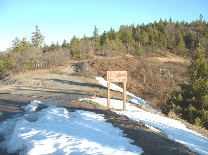
Mendocino Pass Road is a long, remote gravel climb that leaves the small Round Valley town of Covelo, in Mendocino County, and works its way east into the Mendocino National Forest - about 18 miles and 4,900 feet of gain at a steady average grade of roughly 5%. The road (Forest Highway 7, also signed as part of State Route 162) is paved in Covelo but turns to dirt and gravel almost immediately, climbing steadily over Mendocino Pass (5,006 ft) before continuing higher into remote country near Anthony Peak, Mendocino County's second-highest summit at 6,958 feet.
This is part of a well-known bikepacking route connecting Covelo with Elk Creek and Willows in the Sacramento Valley, and it's popular with gravel riders for exactly that reason - a long, steady, scenic grind through National Forest land with very little traffic. Riders have done it on everything from a road bike with 32mm slicks to a dedicated gravel rig; expect some washboard sections but nothing technical.
The tricky part isn't the surface, it's the timing: this is high, exposed country that holds snow into late spring and then turns brutally hot once the snow's gone, leaving a narrow window - usually late spring to early summer - to ride it without either fighting snowpack or getting baked by the heat.
PLAN YOUR ROUTE
 We've partnered with Sherpa-Map.com to bring you the best route planning tool. With a PRO Membership you can use this climb as a reference when creating your route.
 See more details and tools regarding this climb's grade via our interactive Profile Tool.
Roadway: Paved for a short stretch out of Covelo, then wide, well-graded Forest Service dirt/gravel (Forest Highway 7) the rest of the way over Mendocino Pass. As of mid-2026, Mendocino National Forest's road conditions page lists this road as passable; it is not plowed in winter. Expect some washboard sections, but the surface is manageable on a standard gravel bike - riders have done it on 32mm slicks.
Traffic: Very light. This is a remote Forest Service road through Mendocino National Forest with minimal through traffic - mostly local Forest Service, hunting, and recreation vehicles.
Parking: Start in Covelo, where paved State Route 162 gives way to the dirt of Mendocino Pass Road/Forest Highway 7.
There's nothing out here - no water, food, or services anywhere on Forest Highway 7 between Covelo and the far side of the mountains - so carry everything you need and fill up in Covelo before you start.
Standard gravel tires (32mm+) are enough for the washboard and loose gravel sections; no technical skills required, just legs for a long, steady grind.
Sun protection matters as much as cold-weather gear here - this is exposed, high-elevation terrain that can be snow-covered in late spring and scorching by midsummer, sometimes in the same season.
Before heading out on any cycling adventure check out our Things to Bring on a Cycling Trip and use our interactive check list to ensure you don't forget anything.
Timing is everything on this climb: the road holds snow into late spring at this elevation, then the surrounding country gets very hot once it melts out, leaving a narrow window - generally late spring into early summer - to ride it comfortably. Check Mendocino National Forest's current road conditions page before you go, since the road isn't plowed and opening dates shift year to year.
Start early regardless of season - there's no shade for long stretches, and heat builds fast once the sun's up.
Covelo is a small town but has basic food, gas, and lodging; for more services, Willits (about an hour west) or Willows (on the Sacramento Valley side) are the nearest larger towns.
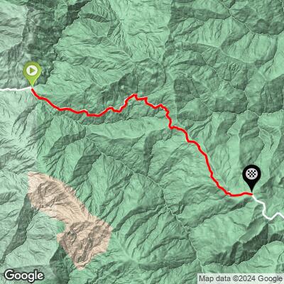
ROUTE MAP
MEMBER RATING
CURRENT WEATHER
PJAMM TRIPS ADVENTURE STARTER BUNDLES
Check out PJAMM Adventure's prepackaged (self-guided) cycling trips. They will help you plan, document and conquer your next adventure.
NEARBY CLIMBS (0) RADIAL PROXIMITY
FROM No Climbs Found
MEMBER REVIEWS & COMMENTS
Let us know what you thought of this climb. Signup for our FREE membership to write a review or post a comment.
Already have an account?
LOG IN HERE
