
24.8
PDI
3.8 mi
DISTANCE
2,494 ft
GAINED
12.6 %
AVG. GRADE
FULL CLIMB STATS
Page Contributor(s): Seth Lancaster, Kneeland, CA; Adam Lawrence, CA
INTRO
PLAN YOUR ROUTE
 We've partnered with Sherpa-Map.com to bring you the best route planning tool. With a PRO Membership you can use this climb as a reference when creating your route.
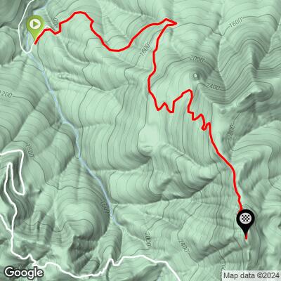
 Grasshopper Road averages 12.59% over its 3.78 miles and rarely lets up. Our data shows 18.3% over the steepest 100 yards, 16.7% over the steepest quarter-mile, 15.6% over the steepest half-mile, and 14.9% over the steepest full mile - there's no real recovery section on the way to the lookout. Gearing matters more here than technical skill, since the surface itself stays smooth, well-graded fire road the whole way. Preview every pitch, kilometer by kilometer, with our Profile tool before you decide on gearing.
Roadway: Entirely unpaved fire road (also mapped as the Grasshopper Multi-Use Trail) in good condition - local riders rate it among the smoothest gravel in the area, with no significant rocks, ruts, or technical features, just a sustained double-digit grade. The road is gated to motor vehicles for its entire length.
Traffic: None from cars - it's closed to motor vehicles. Expect to share the road only with occasional hikers headed to Johnson Camp or Grasshopper Peak, or other mountain bikers.
Parking: The climb starts near Albee Creek Campground on Bull Creek Road/Mattole Road, in the Bull Creek Flats area of Humboldt Redwoods State Park. Park in the day-use pullouts along Bull Creek Road or Mattole Road near the campground - there's no dedicated cycling trailhead lot, and a California State Parks day-use fee may apply.
No services on route or immediately nearby - fill up along the Avenue of the Giants (Redcrest or Miranda) before heading in. Local riders recommend low gearing (near 1:1) for the sustained double-digit grade, and higher-volume tires (38-50mm) for traction and comfort even though the surface itself is smooth dirt. Carry all the water you'll need; none is available on the climb.
Before heading out on any cycling adventure check out our Things to Bring on a Cycling Trip and use our interactive check list to ensure you don't forget anything.
Base out of the Avenue of the Giants corridor - Redcrest, Weott, or Miranda all sit within a few miles. Albee Creek Campground itself offers seasonal tent camping (Memorial Day through Labor Day, reservable via ReserveCalifornia) right at the base of the climb. Pair it with a ride down the nearby Avenue of the Giants for one of California's classic redwood-country cycling days - use our Sherpa Map tool to build a custom multi-climb route through Humboldt Redwoods State Park.
ROUTE MAP
MEMBER RATING
CURRENT WEATHER
PJAMM TRIPS ADVENTURE STARTER BUNDLES
Check out PJAMM Adventure's prepackaged (self-guided) cycling trips. They will help you plan, document and conquer your next adventure.
NEARBY CLIMBS (0) RADIAL PROXIMITY
FROM No Climbs Found
MEMBER REVIEWS & COMMENTS
Let us know what you thought of this climb. Signup for our FREE membership to write a review or post a comment.
Already have an account?
LOG IN HERE
