
32.9
PDI
17.7 mi
DISTANCE
5,507 ft
GAINED
5.5 %
AVG. GRADE
FULL CLIMB STATS
Page Contributor(s): Jon Andrews,
INTRO
Bully Choop is a remote 17.7-mile climb in the Shasta-Trinity National Forest of Northern California, gaining 5,507 feet at a 5.5% average grade to the summit of Bully Choop Mountain (roughly 6,977 feet), on the boundary of Shasta and Trinity counties west of Redding. We currently rank it #33 among the toughest gravel climbs in our worldwide database.
The route starts on paved Platina Road before turning onto Bully Choop Road, a rutted, steep dirt-and-gravel Forest Service road for the final miles to the summit - high-clearance-vehicle territory by car, and a genuine test on a gravel bike. It's a quiet, little-traveled climb; don't expect services, cell coverage, or company along the way.
The summit is capped by a two-story fire lookout tower built in 1978 by the California Department of Forestry, replacing an earlier 1930s-era structure, and it's listed on the National Historic Lookout Register.
The mountain's name is reported to come from a Wintu phrase meaning roughly "high sharp peak." The lookout appears locked and unstaffed in recent visitor reports, so treat it as a scenic landmark rather than an open facility.
PLAN YOUR ROUTE
 We've partnered with Sherpa-Map.com to bring you the best route planning tool. With a PRO Membership you can use this climb as a reference when creating your route.
 Bully Choop climbs 5,507 feet over 17.7 miles at a 5.5% average grade. Research and rider reports describe a gentler start on paved Platina Road, with the grade steepening noticeably once the road turns to dirt and gravel on Bully Choop Road for the final push to the summit - that section is described as rutted and steep enough to warrant a 4x4 by car, so expect the hardest riding late rather than early.
Roadway: The lower miles follow paved Platina Road out of the small community of Platina. The final miles switch to Bully Choop Road, an unpaved, rutted Forest Service road that gets progressively rougher toward the summit - trip reports describe it as high-clearance-vehicle territory, with some recommending 4x4 for the last push to the lookout. Expect a genuinely rough, technical gravel bike finish; wider tires and lower gearing will help.
Traffic: This is a remote, lightly-traveled forest road. Expect little to no vehicle traffic once you leave Platina Road, aside from the occasional Forest Service or fire-lookout-access vehicle. Cell coverage is unreliable in this stretch of the forest, so ride with a partner or a way to call for help if something goes wrong.
Parking: There's no formal trailhead or parking area. Riders typically stage from a pullout along Platina Road near the base of the climb, or from Highway 36 if starting further out. There are no services (water, food, fuel) anywhere on the route - stock up in Platina, Wildwood, or Redding before you go.
This is remote, high-clearance terrain even for a car, so come prepared: wide gravel tires (45mm or wider) with real tread will help on the rutted, rocky surface of Bully Choop Road, and low gearing pays off on the steep, rough final miles to the lookout. There's no water, food, or services anywhere on the route, so carry everything you need for the full out-and-back. Cell coverage is unreliable to nonexistent in this section of the Shasta-Trinity National Forest, so pack a way to navigate and communicate that doesn't depend on a signal.
Before heading out on any cycling adventure check out our Things to Bring on a Cycling Trip and use our interactive check list to ensure you don't forget anything.
Bully Choop sits in the Shasta-Trinity National Forest on the Shasta/Trinity county line, reached via Platina Road off Highway 36 west of Redding. The nearest services are in the small communities of Platina and Wildwood, or in Redding itself if you need anything more substantial - there's nothing at the trailhead or along the climb.
The fire lookout at the summit, built in 1978 and listed on the National Historic Lookout Register, appears locked and unstaffed in recent visitor reports, so treat it as a scenic overlook rather than an accessible facility. Give yourself extra daylight - this is a long, remote climb with no bailout services if something goes wrong.
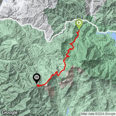
ROUTE MAP
MEMBER RATING
CURRENT WEATHER
PJAMM TRIPS ADVENTURE STARTER BUNDLES
Check out PJAMM Adventure's prepackaged (self-guided) cycling trips. They will help you plan, document and conquer your next adventure.
NEARBY CLIMBS (0) RADIAL PROXIMITY
FROM No Climbs Found
MEMBER REVIEWS & COMMENTS
Let us know what you thought of this climb. Signup for our FREE membership to write a review or post a comment.
Already have an account?
LOG IN HERE
