
31.5
PDI
11.1 mi
DISTANCE
4,545 ft
GAINED
7.6 %
AVG. GRADE
FULL CLIMB STATS
Page Contributor(s): Seth Lancaster, Kneeland, CA
INTRO
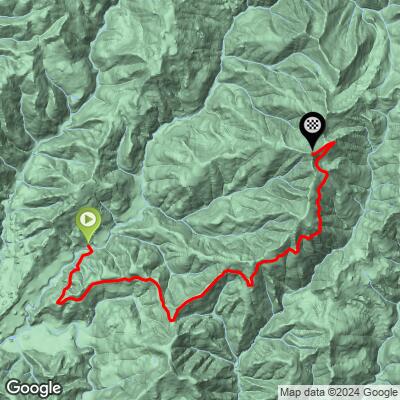
Forest Route 16N02 - known locally as Ship Mountain Road - climbs into the northwest corner of California's Six Rivers National Forest, in the Smith River National Recreation Area near the Oregon border. The route starts along the South Fork Smith River off US-199 near Hiouchi, follows Forest Route 16 upriver toward the Big Flat area, then turns onto 16N02 for the climb itself: 11.1 miles and 4,545 feet of gain to a high ridge near Bear Basin Butte, just over 5,300 feet.
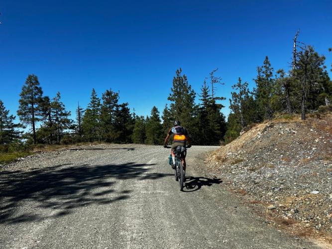
This is genuinely remote climbing. The road serves as access to the Doe Flat, Island Lake, and Bear Basin Lookout trailheads, and a significant stretch of the approach is unpaved with sections of washout, so expect a rougher, more variable surface than a typical maintained gravel road. Old-growth forest lines much of the route, and the upper reaches pass near the Bear Basin Butte Botanical Area, known for an unusual concentration of conifer species growing together on serpentine soil.
Access is seasonal.
The gate near the top of 16N02, close to Bear Basin Lookout, is generally locked mid-October through mid-June (occasionally into July) for snow and to help slow the spread of Port-Orford-cedar root disease - so this is a summer climb, not a year-round one.
Seth Lancaster, a local contributor: "Ship Mountain is indeed perfect for a gravel bike!"
PLAN YOUR ROUTE
 We've partnered with Sherpa-Map.com to bring you the best route planning tool. With a PRO Membership you can use this climb as a reference when creating your route.
 Expect a front-loaded, punchy profile. The steepest quarter mile averages 12.8%, staying nearly that steep over a half mile (12.8%), before settling to 10.7% over a mile, 9.5% over 2.5 miles, and 9.1% over 5 miles. The overall climb averages 7.6% across 11.1 miles - there's no real flat section to recover on.
Roadway: Ship Mountain Road (16N02) is a Forest Service road, and while the approach on Forest Route 16 is graded, a significant stretch of the overall route - roughly 18 miles by Forest Service estimates - is unpaved with areas of washout. Surface quality varies year to year depending on winter damage and how recently the road's been graded; a gravel or adventure bike with wider tires and good tread is the right tool here, not a road bike.
Traffic: Very light. This is a Forest Service access road to trailheads (Doe Flat, Island Lake, Bear Basin Lookout) rather than a through route, so expect the occasional truck or trailhead visitor and little else - especially outside of July and August when the fire lookout is staffed.
Parking: There's no dedicated trailhead lot for the climb itself; riders typically start from a pullout along South Fork Road (FR 16) near Big Flat, or wherever the pavement/maintained-gravel transition makes sense for your plan. No facilities.
A gravel bike with wide, grippy tires is the right call - Seth Lancaster's on-the-ground read was that Ship Mountain suits a gravel bike well, and the mix of graded and washed-out sections backs that up. Carry more water than you'd expect to need; there's no reliable water source on the climb itself. Given the seasonal gate closure (roughly mid-October to mid-June), plan this one for summer, and bring layers - it's forested, high-elevation terrain that can be cool and shaded even when the coast nearby is warm.
Before heading out on any cycling adventure check out our Things to Bring on a Cycling Trip and use our interactive check list to ensure you don't forget anything.
Hiouchi and Crescent City, both a short drive west on US-199, have the nearest gas, food, and lodging. Big Flat Campground, along the South Fork Smith River near the base of this climb, is a primitive option if you want to camp close by. Because the upper gate is seasonal and Forest Service road conditions can change after winter storms, check Six Rivers National Forest's current conditions page (fs.usda.gov/r05/sixrivers/conditions) before you drive out - especially outside of peak summer, when access to the top may not be possible at all.
ROUTE MAP
MEMBER RATING
CURRENT WEATHER
PJAMM TRIPS ADVENTURE STARTER BUNDLES
Check out PJAMM Adventure's prepackaged (self-guided) cycling trips. They will help you plan, document and conquer your next adventure.
NEARBY CLIMBS (0) RADIAL PROXIMITY
FROM No Climbs Found
MEMBER REVIEWS & COMMENTS
Let us know what you thought of this climb. Signup for our FREE membership to write a review or post a comment.
Already have an account?
LOG IN HERE
