
32.4
PDI
7.4 mi
DISTANCE
3,529 ft
GAINED
9.1 %
AVG. GRADE
FULL CLIMB STATS
Page Contributor(s): Brian M., Dorrington, CA; Sean Pinner; Blake Herrmann
INTRO
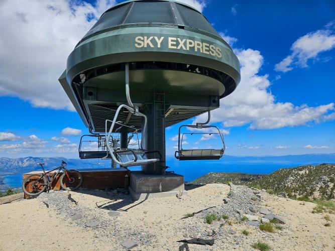
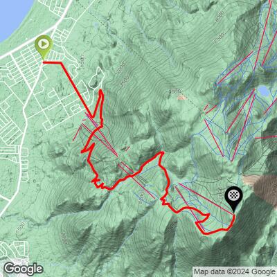
Ridge Run climbs the California side of Heavenly Mountain Resort above South Lake Tahoe - not a ski trail itself, but the resort's network of service roads that switchback up toward the ridge near the top of the actual "Ridge Run" ski run, one of Heavenly's most photographed trails. From a start around 6,300 feet near the base area, the climb gains 3,529 feet over 7.4 miles to just under 9,831 feet, on the shoulder of the resort's upper mountain - not far below Heavenly's high point of roughly 10,067 feet near East Peak.
Two local contributors have ridden it, and both confirm it's genuinely doable on a gravel bike. Brian M.: "Any service road up at Heavenly can be done with a gravel bike." Sean Pinner, who rated the surface 2-3 out of 5 on a smooth-to-very-rough scale: "A gravel bike with something like Pathfinders would be good for this climb. The road surface is fairly good... some chunk from snow melt but nothing serious."
Because this climbs entirely within an operating ski resort's service-road network rather than a public through-road, expect gates, resort maintenance traffic, and access that depends on Heavenly's own summer operations schedule - this isn't a road guaranteed to be open or maintained for cyclists outside the snow-free months.
PLAN YOUR ROUTE
 We've partnered with Sherpa-Map.com to bring you the best route planning tool. With a PRO Membership you can use this climb as a reference when creating your route.
 Ridge Run stays consistently steep with no real flat sections to recover on. The steepest quarter mile averages 13.2%, easing only slightly to 12.6% over a half mile, 12.0% over a full mile, 11.8% over 2.5 miles, and 10.1% over 5 miles - all well above the overall climb average of 9.1% across 7.4 miles. It's one of the steeper, more sustained gravel climbs of its length in the PJAMM database.
Roadway: Entirely on Heavenly Mountain Resort's network of unpaved service roads, built for lift and snowmaking maintenance rather than public traffic. Sean Pinner, who's ridden it, rated the surface 2-3 out of 5 on a smooth-to-very-rough scale - some rough, chunked-up sections from snowmelt runoff, but nothing technical enough to need more than a standard gravel setup.
Traffic: Light and resort-specific - occasional Heavenly maintenance or patrol vehicles rather than public through-traffic, since these roads aren't a public route to anywhere. Access and surface condition can change with the resort's own summer operations schedule.
Parking: No dedicated trailhead for this climb - park in South Lake Tahoe near Heavenly's California base area and start from where the service-road network begins. No facilities once you're on the climb.
Sean Pinner's own gear call applies well here: something like a Pathfinder-style gravel tire is a good match for the mixed graded and rough, snowmelt-chunked surface. Bring your own water - there's nothing available once you leave South Lake Tahoe's base area. At nearly 9,800 feet, expect real elevation effects - pace yourself if you're not acclimated, and bring a layer for the ridge, which is noticeably cooler and windier than the lake shore below.
Before heading out on any cycling adventure check out our Things to Bring on a Cycling Trip and use our interactive check list to ensure you don't forget anything.
South Lake Tahoe has full services at the base - gas, food, lodging, and bike shops. Heavenly Mountain Resort has increasingly leaned into summer mountain-bike access in recent years, including gondola-assisted rides to trails on the upper mountain, so check skiheavenly.com for current summer operations before you go, since service-road access for cyclists depends on what the resort has open that season. This ridge has some of the best lake views in the Heavenly network - worth timing for a clear day.
ROUTE MAP
MEMBER RATING
CURRENT WEATHER
PJAMM TRIPS ADVENTURE STARTER BUNDLES
Check out PJAMM Adventure's prepackaged (self-guided) cycling trips. They will help you plan, document and conquer your next adventure.
NEARBY CLIMBS (0) RADIAL PROXIMITY
FROM No Climbs Found
MEMBER REVIEWS & COMMENTS
Let us know what you thought of this climb. Signup for our FREE membership to write a review or post a comment.
Already have an account?
LOG IN HERE
