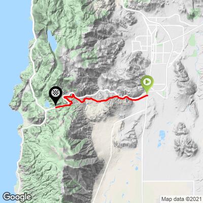
Old Clear Creek Bike Climb - PJAMM Cycling

4.7
FIETS
9.3 mi
DISTANCE
2,391 ft
GAINED
4.9 %
AVG. GRADE

FULL CLIMB STATS

Page Contributor(s): Ravi Raju, San Jose, CA, USA; Jennie Hamiter, Minden, NV, USA.

INTRO

This is a super fun climb out of Nevada's capital.  

See more details and tools regarding this climb's grade via our interactive Profile Tool.
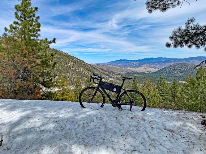
Roadway:  O.k. for the first few miles, but it does break up and include dirt and even some marshy areas.  It is doable on a road bike, though. To get to the summit on this route, you have to ride the last .6 miles from where Old Clear Creek merges onto Hwy 50, against traffic. 

Traffic:  Next to none - and, 0 for the last half. 

Descent:  We rode down Hwy 50 to Golf Club Drive ~4 miles down on the right and finished on the bottom part of Old Clear Creek.  

Private Road + Locked Gate:  See full climb summary.  We were able to do the climb despite several "hey - don't go there"-type signs.  We checked with Strava members who'd done the climb and they gave us the green light.  We didn't encounter any problems along the way. 

Parking:  We parked on the road just across from Costco 1/2 mile up from the start. 
Consider a gravel bike, but the climb was o.k. on my Roubaix with 28mm's.  Do not do this climb during the winter or early spring because there will be snow blocking your way - see Full Summary. 
Before heading out on any cycling adventure check out our Things to Bring on a Cycling Trip and use our interactive check list to ensure you don't forget anything.
Use the “Routes in Area” button on the menu bar above to see other bike climbs in this area.  We do not, however, recommend riding up Hwy 50 to Spooner Summit - very busy highway. 

ROUTE MAP

MEMBER RATING

Difficulty: Moderate
2
Road
5
Traffic
4
Scenery

CURRENT WEATHER

PJAMM TRIPS ADVENTURE STARTER BUNDLES

Check out PJAMM Adventure's prepackaged (self-guided) cycling trips. They will help you plan, document and conquer your next adventure.
ALL TRIPS
Browse all of our prepackaged trips and find your next adventure!

NEARBY CLIMBS (0) RADIAL PROXIMITY

FROM
No Climbs Found

MEMBER REVIEWS & COMMENTS

Let us know what you thought of this climb. Signup for our FREE membership to write a review or post a comment.
Already have an account?

Jul 21, 2021
The road is not open to the public. The residents on the private road installed gates both ends of the road.
Apr 8, 2021
difficulty: Moderate
scenery: 4
traffic: 5
road: 2
Apr 8, 2021
scenery: 4
traffic: 5
road: 2
https://pjammAdventures.com/event/406.old-clear-creek-with-jj
ROUTE MAP
PROFILE TOOL
Route Data
S.G. (%)
hide
Segment Data
hide

Climb Profile Not Found
CLIMB SUMMARY

Cycling Old Clear Creek Road, NV - bike parked in snow on roadside overlooking mountains covered in pine trees

Cycling Old Clear Creek Road, Nevada

Ride 9.3 miles gaining 2,380’ at 4.8% average grade.

This is a fun little climb out of Carson City, Nevada’s state capitol.

Cycling Old Clear Creek Road, NV - bike parked in front of Nevada's state capitol building

State capitol building.

Oddly, on the Google Maps, the first few miles of this route are called Old Lincoln Highway (Highway 50 generally parallels our route as we climb and that is called “Lincoln Highway”).  However, as can be seen from the street sign just up from the start, the road is marked throughout as “Old Clear Creek Road.”

Cycling Old Clear Creek Road, NV - signs along the roadway on the climb

Signs about half a mile from the start of the climb.

Nice input from Jennie Hamiter, Minden, NV:

“I wasn’t sure if you were interested in taking the road all the way to the top of Spooner, vs getting on Highway 50 at that onramp about 1/3 of the way up Spooner.  If you’re on a road bike, then you’ll want to take that onramp onto 50.

If you continue on Old Clear Creek Rd, the road gets skinnier and more dilapidated, with some patches of dirt for 10-50 feet, and if I recall there’s at least 1 swampy area.  I did it on a gravel bike a couple summers ago, and it becomes an adventure, but it’s fun to do it once anyway.  The worst part is that at the top of Old Clear Creek, where it dumps you out  on 50 not too far from the summit, there’s a concrete barrier across Hiway 50 so you have to go the wrong way up the hi way for quarter/half a mile, and there’s a concrete barrier on the side of the road, too, so you can’t even get off the road.

Fun terrain to explore. Have fun!”

Cycling Old Clear Creek Road, NV - bike parked in front of rock formations and a rock climbing wall on roadside

There are neat rock formations and climbing wall at mile 1.5.

Cycling Old Clear Creek Road, NV - bike parked next to sign for Clear Creek Connection, bike parked in snow on side of road, PJAMM Cyclist stands with bike propped on fallen log

The road is a bit rugged in spots but can be done on a road bike.

Cycling Old Clear Creek Road, NV - road veers at mile 4.5

Veer left precisely at mile 4.5 - it is not obvious - we missed this turn . . . more than once . . . 😒

Cycling Old Clear Creek Road, NV - GPS navigation shows confusion in where the turn is

Our GPS tracks are not supposed to look like that!

Cycling Old Clear Creek Road, NV - PJAMM Cyclist rides bike on road beyond closed gate

O.k. - here’s the thing about this climb - from nearly the start and for many times along the climb you will see “no trespass” and “locked gate ahead” signs.  We were alerted to this in advance and consulted with several Strava members who had ridden this route before - their comments are below.  The only closed and locked gate we encountered was at mile 4.6 and that was for a very short stretch of road (about 100 yards).  Our conclusion is (1) ride at your own risk and (2) it seems o.k., just be respectful and cautious.

Cycling Old Clear Creek Road, NV - cyclists walk bikes through very thick snow on roadway

Our #1 tip for this ride - do it during the summer . . .

Cycling Old Clear Creek Road, NV - cyclists walk bikes through very thick patches of snow on roadway

Cycling Old Clear Creek Road, NV - bear tracks found in snow on roadway

Bear tracks.

Cycling Old Clear Creek Road, NV - view from climb looking east toward Carson City; view of Old Clear Creek junction with Highway 50

Left photo: View back towards Carson City;

Right photo: View of Old Clear Creek junction with Highway 50.

Photo right:  Old Clear Creek merges onto Highway 50 at mile 8.7, leaving 0.6 miles riding against Highway 50 traffic to the summit.  There is a significant barrier dividing four lanes of Highway 50 where Old Clear Creek merges with the Highway. This is the sketchiest part of the ride, and you should probably turn right and just ride down Highway 50 to Golf Course Drive about four miles down on the right and merge back onto Old Clear Creek there - or, just ride back down bumpy and rough Old Clear Creek.  However, we did (foolishly?) ride against traffic to the top - not recommended.

Below are Strava members’ responses to my question:  “I would like to ride Old Clear Creek from Carson City to the top - do you know if the road generally ok to use by cyclists even though it is apparently technically on private property?”

#1:  “Old Clear Creek is fine.  You’ll be o.k.”

#2:  “It says private road, however it is the old Hwy 50. I think they are just trying to keep potential campers and  looky Lew’s out! I’ve ridden it many times!

#3:  “Old Clear Creek is in pretty rough shape, but rideable.”

#4:  “The road has been in dispute for many years, but cyclist friends of mine who have contacted Carson City have been assured it's a public road. I've never been hassled by anyone when I've ridden up it, in fact drivers and dog walkers have always been friendly, but there's been the odd report of riders who have been hassled.”

Cycling Old Clear Creek Road, NV - PJAMM Cyclists stand with bikes next to road sign for Spooner Summit, Elevation 7146

That’s a wrap!!