
23.3
PDI
11.7 mi
DISTANCE
3,806 ft
GAINED
5.9 %
AVG. GRADE
FULL CLIMB STATS
Page Contributor(s): Joey Galloway, Exeter, CA
INTRO
PLAN YOUR ROUTE
 We've partnered with Sherpa-Map.com to bring you the best route planning tool. With a PRO Membership you can use this climb as a reference when creating your route.
 Forest Road 93 gains about 3,800 feet over 11.7 miles for an overall average of a bit over 6%, but the grade is uneven rather than a steady grind. Sections through the lower and middle portions pitch up into the 8-10% range on shaded switchbacks, alternating with mellower stretches where the road contours along the hillside.
The final approach to Packer Saddle tends to ease off compared to the steepest middle section. The loose gravel and occasional washboard surface make the effort feel harder than the average grade alone suggests, especially on a loaded bike.
Roadway: Forest Road 93 is unpaved for virtually its entire length, a mix of hardpacked dirt and loose gravel with occasional washboard and ruts typical of a Forest Service road built for logging and recreational access rather than daily traffic. A gravel bike with tires in the 40mm-plus range is recommended; narrower tires struggle on the looser sections, especially after rain.
Traffic: Traffic is very light - mostly other cyclists, occasional Forest Service vehicles, and shuttle trucks running mountain bikers up to the Downieville trail network. There's little reason to expect meaningful car traffic once you leave Highway 49.
Parking: Most riders park along the shoulder of Highway 49 near Union Flat Campground, directly across from the start of FR-93, or inside the campground's day-use area when it's open (Memorial Day through Labor Day). There's no dedicated trailhead lot at the base of the climb itself.
A gravel or adventure bike with wide, knobby tires (40mm or wider) and a wide-range gearing setup is the right tool here - the loose surface and steep pitches make low gears more valuable than aerodynamics.
Bring more water than you'd carry on a paved climb of similar length; there's no reliable water source on the road itself. There are no stores, gas stations, or bike shops along the route - Downieville, about 15 minutes away by car, has the nearest services, including a bike shop used to the area's mountain biking crowd.
Cell service is spotty to nonexistent for most of the climb, so let someone know your plans before heading out.
Before heading out on any cycling adventure check out our Things to Bring on a Cycling Trip and use our interactive check list to ensure you don't forget anything.
Downieville makes the best base for a trip up Forest Road 93 - it's a small Gold Rush-era town with a few restaurants, a general store, and lodging, sitting at the hub of the Lost Sierra's mountain biking and gravel scene. The climb pairs naturally with a stay in town and a post-ride swim in the North Yuba River in summer.
Because the upper part of the climb sits well above 6,000 feet, mornings can be cold even in summer - dress in layers and check conditions at the top with our Weather tool before you go. Packer Saddle connects into the Gold Lake Highway and Lakes Basin area, and several other climbs in the surrounding Sierra Buttes/Lost Sierra region are worth combining into a longer trip.
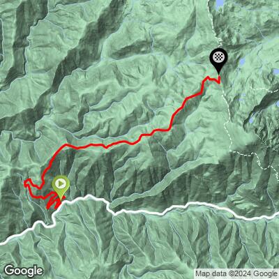
ROUTE MAP
MEMBER RATING
CURRENT WEATHER
PJAMM TRIPS ADVENTURE STARTER BUNDLES
Check out PJAMM Adventure's prepackaged (self-guided) cycling trips. They will help you plan, document and conquer your next adventure.
NEARBY CLIMBS (0) RADIAL PROXIMITY
FROM No Climbs Found
MEMBER REVIEWS & COMMENTS
Let us know what you thought of this climb. Signup for our FREE membership to write a review or post a comment.
Already have an account?
LOG IN HERE
