
31.1
PDI
11.5 mi
DISTANCE
4,236 ft
GAINED
7 %
AVG. GRADE
FULL CLIMB STATS
Page Contributor(s): Matt Davey, Redmond, OR; Ice Violet; Brad Herauf, Sisters, OR
INTRO
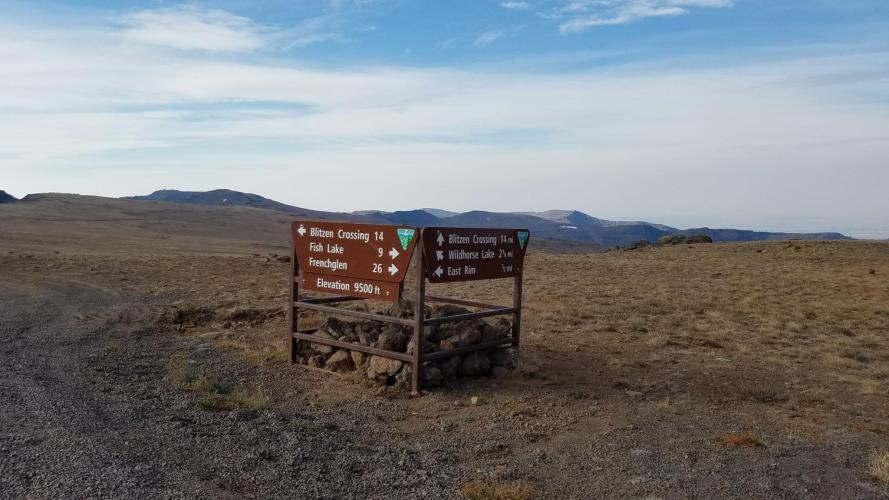
Steens Mountain rises out of Oregon's high desert to become the tallest peak in the state's southeast corner, and its North Loop Road climbs the mountain's steep north face on mostly gravel surface to a summit ridge above 9,700 feet - among the highest roads in Oregon. Our measured segment covers the steeper upper portion of that climb: 11.5 miles and 4,236 feet of gain at an average 7% grade, starting around 5,345 feet and finishing at 9,552 feet near the true summit.
What makes this climb remarkable is the view, not just the effort. You're riding a fault-block mountain that rises almost a full vertical mile above the Alvord Desert playa to the east - one of the most dramatic escarpments in the American West. Along the way you pass Fish Lake and Jackman Park, high alpine camps above 7,000 feet, before the road works its way up toward overlooks of Kiger Gorge and the East Rim, glacier-carved canyons that drop away thousands of feet.
This is a seasonal road only - the upper section near the summit typically opens in late June and closes again by mid-October, and the full loop is usually gated by winter snow from November through spring.
A 2023 rockfall near Big Indian Gorge closed a section of the broader loop road for a time, but it has since been repaired; as of the 2026 season the road is reported fully open. Confirm current conditions with the BLM's Burns District office before you go, since this is a remote high-desert road with real weather exposure.
PLAN YOUR ROUTE
 We've partnered with Sherpa-Map.com to bring you the best route planning tool. With a PRO Membership you can use this climb as a reference when creating your route.
 At 6.96% average over 11.5 miles, this is a genuinely sustained gravel climb, not a gentle grade with a few pitches - contributor Matt Davey describes it as steep enough, combined with the elevation gain, to make for a very challenging ride even before altitude and wind are factored in. Expect the grade to hold fairly consistently through the climb rather than easing into flat recovery stretches, with the final approach to our 9,552-foot finish among the more exposed sections as you near the summit ridge above 9,700 feet.
Roadway: The North Loop Road is unpaved for most of its length - a maintained gravel and dirt BLM road rather than pavement. Contributor Matt Davey rated the surface a 2 out of 5 for roughness and rode it on a gravel bike with 38mm tires without issue, but expect washboard sections and some looser gravel, especially after rain. The road is seasonal: the upper section near Fish Lake, Jackman Park, and the summit typically isn't open until late June and closes again by mid-October, well before the lower loop shuts down for winter. A 2023 rockfall near Big Indian Gorge closed part of the broader Steens Loop for a time; it has since been repaired, and the road is reported fully open for the 2026 season - still worth confirming current status with the BLM Burns District office before a trip.
Traffic: Traffic is light - this is a remote gravel road in a sparsely populated part of southeast Oregon, used mostly by other recreational visitors, campers headed to Fish Lake or Jackman Park, and the occasional ranch or BLM vehicle. Wind, not vehicles, is the bigger hazard near the top; open, exposed sections near the summit ridge can see strong gusts.
Parking: There's no formal trailhead parking for this specific segment. Riders typically stage from Fish Lake Campground or Jackman Park Campground, both just below the climb's upper reaches, or from a pullout along the North Loop Road itself.
Run real gravel tires - contributor Matt Davey used 38mm tires on a gravel bike without trouble, rating the surface a 2 out of 5 for roughness. Pack layers regardless of the season: the summit ridge sits above 9,700 feet with potential for high wind, and temperatures at the top can be dramatically colder and windier than the desert floor below.
There's no reliable water or food source directly on this segment - fill up before you start, since the nearest services are in Frenchglen, well down the mountain. Fish Lake and Jackman Park campgrounds have basic facilities in season but shouldn't be counted on for supplies.
Before heading out on any cycling adventure check out our Things to Bring on a Cycling Trip and use our interactive check list to ensure you don't forget anything.
Frenchglen, at the base of the mountain, is the closest town with lodging (a small historic hotel) and is the standard base for a Steens Mountain trip. Burns, about 60 miles north, has fuller services if you need them.
Plan around the season - the upper section of this climb is typically only open late June through mid-October, and conditions can shift fast at this elevation even within that window.
Check current road status with the BLM's Burns District office (or Oregon's TripCheck) before you commit to a trip, since this is a genuinely remote area with long distances between services.
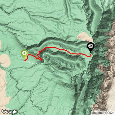
ROUTE MAP
MEMBER RATING
CURRENT WEATHER
PJAMM TRIPS ADVENTURE STARTER BUNDLES
Check out PJAMM Adventure's prepackaged (self-guided) cycling trips. They will help you plan, document and conquer your next adventure.
NEARBY CLIMBS (0) RADIAL PROXIMITY
FROM No Climbs Found
MEMBER REVIEWS & COMMENTS
Let us know what you thought of this climb. Signup for our FREE membership to write a review or post a comment.
Already have an account?
LOG IN HERE
