11.1
PDI
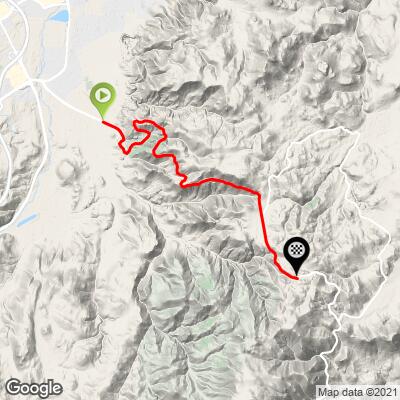
7.6 mi
DISTANCE
2,056 ft
GAINED
5.1 %
AVG. GRADE
FULL CLIMB STATS
Page Contributor(s): Christopher Jacobs, Byers, CO, USA
INTRO
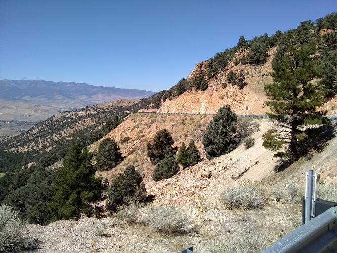
When it comes to cycling in the Reno area, there are few routes as popular or as frequently ridden as Geiger Grade. Starting in South Reno, Geiger Grade is the winding road that cars and drivers alike take to get to Virginia City, one of the most historic towns in the United States.
"The climb to Geiger Summit begins close to busy Highway 395 south of Reno but soon retreats to more secluded high desert mountain surroundings. A somewhat shallow start moves into the hills through a few elegant curves along a tight road (guard rails). Never steep, the hill is still a good workout but keep in it will be warm in the summer. The grade eases a bit just before the signed summit..." (This quote is presented with the approval of John Summerson, from his book, The Complete Guide to Climbing (by Bike), 2nd Edition, pg. 193.)
PLAN YOUR ROUTE
The average grade of the Geiger Grade bike climb is 5.2%. 30% (2.3 miles) of the ride is at 0-5%, 69% (5.3 miles) is at 5-10% average grade. The steepest quarter-mile is 6.3% and steepest continuous mile is 6.1%. The grade on the climb is very consistent.
See more details and tools regarding this climb's grade via the “Profile Tool” button.
Roadway: Excellent condition with a shoulder most of the climb. The climb is on 2 lane Highway 341 and traffic does pass at highway speeds.
Traffic: Geiger is the only way up to Virginia City, which is a popular tourist attraction so it can sometimes have relatively high traffic on the weekends or holidays. Getting out early in the morning on weekends helps to beat the cars. During the week there is pretty mild traffic, with most cars likely being commuters either to VC for work, or more likely from VC into Reno. There’s a shoulder, but it isn’t all that wide and there is usually a metal barrier between you and the side of the mountain.
Parking: On Kivett Lane just off Highway 341 at the start of the climb - Map; Street View.
Provisions: There is a deli near the start of the climb on Hwy 341 and also in Virginia City 10.5 miles away and over Geiger Summit.
Before heading out on any cycling adventure check out our Things to Bring on a Cycling Trip and use our interactive check list to ensure you don't forget anything.
Visiting Virginia City is like being transported in a time machine back to the Sierra Nevada's gold rush days - Street View. Here are the stats for the ride back back up Geiger Grade South to Geiger Summit.
There are numerous hotel options in Reno, which is your "best bet" to stay close to this climb! You can also find many reasonable house rentals here too.
ROUTE MAP
MEMBER RATING
CURRENT WEATHER
PJAMM TRIPS ADVENTURE STARTER BUNDLES
Check out PJAMM Adventure's prepackaged (self-guided) cycling trips. They will help you plan, document and conquer your next adventure.
NEARBY CLIMBS (0) RADIAL PROXIMITY
FROM No Climbs Found
MEMBER REVIEWS & COMMENTS
Let us know what you thought of this climb. Signup for our FREE membership to write a review or post a comment.
Already have an account?
LOG IN HERE
Adrian
i did this ride in mid february from reno to virginia city. at the start, it was completely rocky, orange, and pretty dry. but by the top of the climb, dude it was slightly snowing and everything was covered. i only wore a t shirt since i didn't think it was gonna be like that at the top. anyways, the views were crazy and i would definitely ride this again. wasn't much traffic either. virginia city is a cool little town, i went to this apple restaurant thing, and the waiter left in the middle to go and deliver an order to someone in town. pretty cool vibe