15.2
PDI
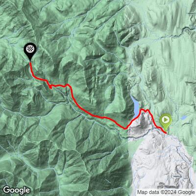
6.8 mi
DISTANCE
2,455 ft
GAINED
6.8 %
AVG. GRADE
FULL CLIMB STATS
Page Contributor(s): Juan Camilo Echeverri, Washinton DC
INTRO
PLAN YOUR ROUTE
This climb averages 0%. The steepest quarter mile of this climb is 0%. NaN miles of the climb is at or above 10% grade. The gradient on this climb is broken down as follows:
See more details and tools regarding this climb's grade via our interactive Profile Tool.
See more details and tools regarding this climb's grade via our interactive Profile Tool.
Information Not Available
If you have any information regarding this climb, we'd like to hear from you. Click the CONTRIBUTE button to share your thoughts with us.
Information Not Available
If you have any information regarding this climb, we'd like to hear from you. Click the CONTRIBUTE button to share your thoughts with us.
Before heading out on any cycling adventure check out our Things to Bring on a Cycling Trip and use our interactive check list to ensure you don't forget anything.
Information Not Available
If you have any information regarding this climb, we'd like to hear from you. Click the CONTRIBUTE button to share your thoughts with us.
ROUTE MAP
MEMBER RATING
CURRENT WEATHER
PJAMM TRIPS ADVENTURE STARTER BUNDLES
Check out PJAMM Adventure's prepackaged (self-guided) cycling trips. They will help you plan, document and conquer your next adventure.
NEARBY CLIMBS (0) RADIAL PROXIMITY
FROM No Climbs Found
MEMBER REVIEWS & COMMENTS
Let us know what you thought of this climb. Signup for our FREE membership to write a review or post a comment.
Already have an account?
LOG IN HERE
MethowBiker
This climb is now part of the Olympic area gravel racing series. It’s a steady climb from Quilcene with forest roads and occasional territorial views. Best to do after a period of dry weather as parts can be quite muddy. Great coffee in quilcene near the usfs ranger station. And quilcene cafe is a nice place for dinner too. No services and limited to no cell service. You can make a longer day, easily up to 75 miles and 9,000 ft of vert if you’ve got the legs for it . See the Bon Jon Passout gravel race page for rwgps routes.