
23
PDI
11.4 mi
DISTANCE
3,818 ft
GAINED
6.3 %
AVG. GRADE
FULL CLIMB STATS
Page Contributor(s): Aaron Steege-Jackson, Poulsbo, WA
INTRO
PLAN YOUR ROUTE
 We've partnered with Sherpa-Map.com to bring you the best route planning tool. With a PRO Membership you can use this climb as a reference when creating your route.
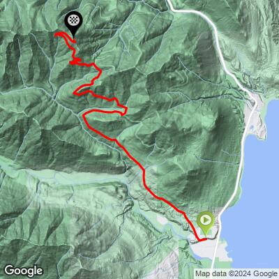
 NF Road 2620 South gains about 3,800 feet over 11.4 miles for an average grade a bit over 6%. The road isn't a steady grind - riders report a mix of moderate sustained sections and rougher, chunkier pitches, especially on the descent back toward Highway 101, where the surface has been described as chunky enough to punish anything narrower than a 42mm tire.
Expect the grade and surface quality to vary more than the average number alone suggests - this is an unmaintained-feeling forest road, not a groomed gravel route.
Roadway: NF Road 2620 (Rocky Brook Road) is a rough, lightly maintained Forest Service road for essentially its entire length - hardpack and loose gravel with rutted, chunky sections, particularly on the upper mountain and the descent. Riders have reported it's best ridden on tires 42mm or wider; narrower gravel tires struggle on the roughest stretches. Expect at least one gate to hop and a posted no-trespassing area near communication towers close to the top, which typically means walking the final section rather than riding through.
Traffic: Traffic is very light and mostly limited to occasional logging or utility vehicles - this is a genuinely quiet, lightly used forest road, not a through route.
Parking: There's no formal trailhead lot for the climb itself; riders typically park along the shoulder of Highway 101 near the Rocky Brook Road turnoff, about 4.8 miles south of the Quilcene Ranger Station, or use the small pullout hikers use for the Elbo Creek trailhead a short way up the road.
A gravel bike with 42mm or wider tires is strongly recommended - narrower tires struggle on the rough, chunky sections reported on both the climb and the descent. Bring all the water and food you'll need; there are no services anywhere on the route. Quilcene, about 10 minutes north on Highway 101, has the nearest gas station and small grocery store.
Cell coverage is unreliable to nonexistent for most of the climb, so let someone know your route before heading out, and be prepared for some hike-a-bike near the top.
Before heading out on any cycling adventure check out our Things to Bring on a Cycling Trip and use our interactive check list to ensure you don't forget anything.
Quilcene and Brinnon, both small Highway 101 towns on Hood Canal, are the practical bases for this climb - neither has much beyond basic services, so many riders stay in Port Townsend or Sequim and drive down for the day.
Because this is a remote, lightly-traveled forest road with gates and posted areas near the top, treat it as a backcountry ride rather than a casual gravel outing, and check current conditions with Olympic National Forest's Hood Canal Ranger District before heading out if you haven't ridden it recently. If you're building a bigger day around it, our Routes in the Area tool is a good way to see what else is nearby on the Olympic Peninsula.
ROUTE MAP
MEMBER RATING
CURRENT WEATHER
PJAMM TRIPS ADVENTURE STARTER BUNDLES
Check out PJAMM Adventure's prepackaged (self-guided) cycling trips. They will help you plan, document and conquer your next adventure.
NEARBY CLIMBS (0) RADIAL PROXIMITY
FROM No Climbs Found
MEMBER REVIEWS & COMMENTS
Let us know what you thought of this climb. Signup for our FREE membership to write a review or post a comment.
Already have an account?
LOG IN HERE
