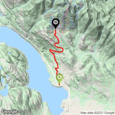
9.7
PDI
4.8 mi
DISTANCE
1,624 ft
GAINED
6.4 %
AVG. GRADE
FULL CLIMB STATS
Page Contributor(s): Bruce Hamilton, La Quinta, CA, USA; Stacy Topping, Tacoma, WA, USA
INTRO
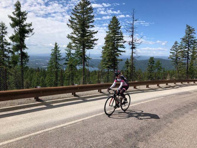
Big Mountain starts at the east shore of Whitefish Lake a couple of miles north of Whitefish. It’s just under five miles and about 1700 feet of elevation gain to ride to the end of the road at the ski resort. There are residential areas on the mountain and these go higher. You can ride a paved road through a very nice housing development and top out at over 5000 feet (the ski area parking lot is at about 4700 feet).
PLAN YOUR ROUTE
Average grade is 6.4%. 61% of the climb is at 5-10% grade and 10% is at 10-15%. The steepest quarter-mile is 10.7%.
See more details and tools regarding this climb's grade via the “Profile Tool” button.
Roadway: This is a two lane road in good condition with a double yellow line and a narrow to moderate width shoulder.
Traffic: Light.
Parking: Park on the side of the East Lakeshore Drive just east of the beginning of the climb on Big Mountain Road (Map; Street View).
Provisions: If the facilities are open, there are a couple of restaurants at Whitefish Mountain Resort at the finish of the climb. There are also plenty of locations for food and beverages in Whitefish where the climb begins.
Before heading out on any cycling adventure check out our Things to Bring on a Cycling Trip and use our interactive check list to ensure you don't forget anything.
During the summer there are many fun things to do around Whitefish, including golf, mountain bike riding at Whitefish Mountain Resort, and water activities on Whitefish River and Lake. Glacier National Park (PJAMM climb page) is only 27 miles from Whitefish - you can stay in Whitefish and climb Logan Pass East and/or Logan Pass West.
ROUTE MAP
MEMBER RATING
CURRENT WEATHER
PJAMM TRIPS ADVENTURE STARTER BUNDLES
Check out PJAMM Adventure's prepackaged (self-guided) cycling trips. They will help you plan, document and conquer your next adventure.
NEARBY CLIMBS (0) RADIAL PROXIMITY
FROM No Climbs Found
MEMBER REVIEWS & COMMENTS
Let us know what you thought of this climb. Signup for our FREE membership to write a review or post a comment.
Already have an account?
LOG IN HERE
SeaRobin
Pretty consistent climb, stays at 6-8% the whole way through so it's very easy to pace. The scenery is insane, you basically get a view into the whole entire valley. The road in the steepest sections has a huge shoulder which allows you to avoid some traffic. Decent is a little sketchy because of potholes being scattered about the road.