
27.3
PDI
6.5 mi
DISTANCE
3,268 ft
GAINED
9.4 %
AVG. GRADE
FULL CLIMB STATS
INTRO
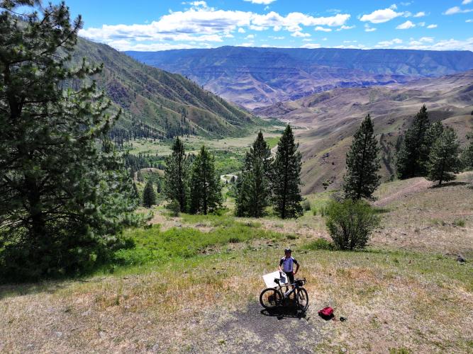
Pittsburg Landing Road is a short, brutally steep gravel climb on Forest Road 493 (Deer Creek Road), the narrow road connecting White Bird, Idaho to Pittsburg Landing on the Snake River, deep in Hells Canyon - the deepest river gorge in North America.
This climb covers 6.5 miles and 3,268 ft of climbing at a 9.4% average grade, gaining out of the canyon from around 1,200 ft to roughly 4,400 ft.
It's single-lane gravel the entire way, with tight switchbacks, real exposure, and essentially no traffic beyond the handful of vehicles headed to the boat launch or campground at the bottom. This is one of only two Idaho-side road accesses into Hells Canyon, and the reward is a close-up view of the Snake River far below.
Pittsburg Landing was once a Native American village site before becoming a river-access point and campground; today it's a put-in/take-out for permitted Snake River trips, with a small fee campground (no potable water). The road is county-maintained but not kept open year-round, and can require chains in winter. As of this writing (fall 2026) there's no reported closure on this stretch, but fire danger in the surrounding Nez Perce-Clearwater National Forest is currently rated High, so check current conditions before heading down.
PLAN YOUR ROUTE
 We've partnered with Sherpa-Map.com to bring you the best route planning tool. With a PRO Membership you can use this climb as a reference when creating your route.
 This climb is steep from the very first pedal stroke and stays that way - the opening quarter-mile averages 13.5%, and even the full first 2.5 miles hold nearly 11%. There's no flat or downhill respite on the way up; the steepest 100 yards on the route touches over 14%. See our interactive Profile Tool for the full gradient breakdown by segment.
Roadway: Single-lane gravel the entire way. Forest Road 493, also called Deer Creek Road or Pittsburg Road, is narrow with tight switchbacks and real exposure in spots. The county maintains it, but not year-round; it's steepest and narrowest right where it drops into the Hells Canyon National Recreation Area, which is the stretch this climb covers.
Traffic: Very light. This is a dead-end access road to a boat launch and small campground, not a through-route, so expect only the occasional vehicle headed to or from the river - more on summer weekends when rafters and campers are moving gear.
Parking: There's no dedicated trailhead. Riders typically start from Old Highway 95 near White Bird, where Forest Road 493 begins after crossing the river bridge, or from Pittsburg Landing itself at the bottom, which has a boat launch, small campground ($8/night fee), and parking (no potable water on site).
Traffic: Very light. This is a dead-end access road to a boat launch and small campground, not a through-route, so expect only the occasional vehicle headed to or from the river - more on summer weekends when rafters and campers are moving gear.
Parking: There's no dedicated trailhead. Riders typically start from Old Highway 95 near White Bird, where Forest Road 493 begins after crossing the river bridge, or from Pittsburg Landing itself at the bottom, which has a boat launch, small campground ($8/night fee), and parking (no potable water on site).
This is a short, steep effort with real heat exposure - Hells Canyon's lower elevations run hot and dry in summer, and there's no shade or water along this gravel stretch. Carry more water than a 6.5-mile climb would normally suggest.
A gravel or mountain bike with wider tires is the right call for the loose surface and tight switchbacks; low gearing matters given the 9.4% average, with pitches into the mid-teens in spots.
The road isn't maintained year-round and can be snowed in or icy in winter - this is a spring-through-fall climb for most riders.
Before heading out on any cycling adventure check out our Things to Bring on a Cycling Trip and use our interactive check list to ensure you don't forget anything.
White Bird, on Highway 95, is the closest town and the natural staging point - it's small, but it's the last real services before the gravel starts. Riggins, about 45 miles north via Highway 95, and Grangeville, roughly 30 miles east, are the nearest towns with fuller services and lodging.
Fire danger in the Nez Perce-Clearwater National Forest is currently rated High, with Stage 1 fire restrictions in effect - check current Forest Service alerts before you go, especially in late summer and fall.
If you want to extend the trip, Pittsburg Landing at the bottom is a put-in/take-out point for permitted Snake River trips through Hells Canyon, and a small fee campground if you want to camp at the river before or after the ride.
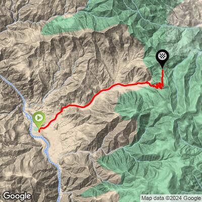
ROUTE MAP
MEMBER RATING
CURRENT WEATHER
PJAMM TRIPS ADVENTURE STARTER BUNDLES
Check out PJAMM Adventure's prepackaged (self-guided) cycling trips. They will help you plan, document and conquer your next adventure.
NEARBY CLIMBS (0) RADIAL PROXIMITY
FROM No Climbs Found
MEMBER REVIEWS & COMMENTS
Let us know what you thought of this climb. Signup for our FREE membership to write a review or post a comment.
Already have an account?
LOG IN HERE
