![]()
Cycling Trinity Lookout
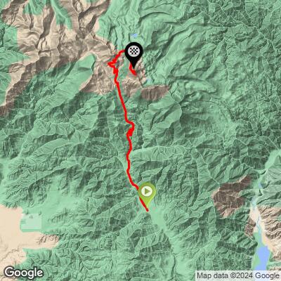
Ride 13.2 miles gaining 4,508’ at 6.2% average grade (7.7% climb only) to 9,500’
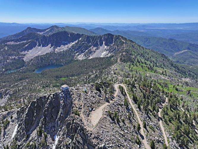
Perched on the face of a sheer 500’ cliff, this is a Top 10 US Most Epic Gravel Climb and ranked the #30 most difficult US gravel bike climb.
![]()
The lookout was originally built in 1922 and the current feat of engineering was constructed in 1957.
Climb Summary by PJAMM’s Brad Butterfield
Located in the Boise National forest, the road that this climb follows is a very popular destination for off-road vehicle recreation. During the course of the climb, I was passed by an ATV or dirt bike every 5 minutes or so. Luckily, about a third of the way up the climb, there was a gate which is closed until July 15th - keeping motorized vehicle traffic off of the road. The road itself is very rough and rocky in sections. It is rideable on a gravel bike, but I would recommend at least 45mm tires. The final 2 miles to the lookout is exceptionally rough and steep. When PJAMM rode the climb in early July, the lookout was unmanned and locked - however I was told by locals that the lookout is still in use during the late summer months. The lookout provides exceptional 360 degree views of the surrounding mountains. Don’t miss out on this one, it is well worth the effort to reach the summit!
![]()
Start of climb - Intersection of Trinity Ridge and Meadow Creek Road
Note - Google Maps has Meadow Creek as Long Gulch Road but OSM is Meadow Creek
Trinity Mountain and Trinity Lookout are located in Boise National Forest (established 1908; 2,203,703 acres; ~1.1m annual visitors) in the heart of the Boise Mountains, a subrange of the Rocky Mountains. Trinity Mountain is about a 2.5-hour drive northeast of Boise.
![]()
Beware the weather can be cold and snow in early spring and late fall, and
100 degree scorching temperatures during the summer.
![]()
Photos along the middle section of the climb.
![]()
Gate 1 at mile 8.8
The steepest mil of the climb ends about a mile before the gate and averages 11%.
![]()
2 of the 5 hairpins between miles 9-10.5
![]()
5 hairpins from miles 9-10.5 at 9.7% average grade.
![]()
We ran into a boulder and tree blocking the road during our climb in July, 2024.
![]()
The roadway surface varies from smooth at the bottom to very rough at the top.
![]()
Photos along the climb between the first and second gates.
![]()
Gate 2 mile 11.4
It is 1.8 miles at 9.6% average grade from the gate to the top.
The steepest quarter mile of the climb is 15.2% and begins just after the gate
![]()
Trinity Peak and Lookout
The highest road in Idaho.
![]()
The Lookout is on site from several miles away.
![]()
There are segments where we ride along a sheer cliff.
![]()
Final approach
![]()
This is the sign just below and before we reach the Lookout Tower.
![]()
One of the most sensational gravel climb finishes in the US.
The U.S. Forest Service is the organization responsible for owning and maintaining Trinity Lookout
![]()
The US Coast & Geodetic Survey (now part of the National Geodetic Survey) typically placed survey markers and reference marks on prominent peaks and other important locations to assist in locating Triangulation Stations and were commonly stamped with "REFERENCE MARK" and had an arrow symbol pointing toward the main station mark.
Inscription on the Geodetic Survey mark on Trinity Peak:
"U.S. COAST & GEODETIC SURVEY REFERENCE MARK":
"FOR INFORMATION WRITE TO THE DIRECTOR WASHINGTON D.C.":
"$250 FINE OR IMPRISONMENT FOR DISTURBING THIS MARK":
![]()
Trinity Lookout is an active fire lookout as of 2024.
Trinity Peak Lookout has a rich history dating back to the early 20th century. The site was first developed in 1922, with the original structure being a 12' x 12' stone cabin featuring an iron roof. However, the current building that stands today is not the original. The present structure was built in 1956 and consists of a concrete base topped with a lookout cabin sitting atop the sheer northern face of Trinity Peak.
![]()
![]()
That’s a wrap!!
PS: Notes from Straval members who provided us information as we searched for the top 100 US Gravel Climbs in 2024. These comments were provided before we actually did the climb:
Chris Stuart - I’ve done it on a gravel bike a couple years ago. The final climb to the lookout might be a little bit of a hike.
Alex Martinek - . The road is pretty good. Definitely want a good low gear. I had 36x50 and that was pretty good. If you take the path to the lookout it’s a bit of hike a bike unless you’re riding an mtb. I’d recommend at least 42c tires for the climb.
Mike Atkins - I've only climbed this with a gravel bike. There are some sections to the lookout where fatter tires and lower gearing would be better, but those sections aren't very long. There's still over 2 ft of snow up there, so it's still early - check snow level here - https://www.nwrfc.noaa.gov/snow/snowplot.cgi?TRMI1
Troy Nichol - MTB better, but this climb can be done on a gravel bike - I had to walk in a few spots, but its epic.