![]()
Cycling Magruder Corridor
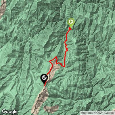
Ride 13 miles gaining 4,479’ at 6.5% average grade.
![]()
Climb summary by PJAMM’s Brad Butterfield.
The Magruder Corridor is located deep within the Nez Perce National Forest. To reach this climb, you'll have to drive (or ride) for nearly 100 miles on a narrow, one-lane dirt road without any services from the west side. While some sections of the road to Magruder from Elk City are decent, other sections are in quite poor condition. A high-clearance vehicle with 4x4 as well as a spare gas can are strongly advised for anyone making the trek. Accessing from the east is around 20 miles of dirt road and another 20 miles of remote paved road. All this to say, this climb is one of the most remote on the PJAMM site. Come prepared with all provisions. The climb itself begins at the Selway River and follows a steep mountain without twisting or winding too much. Unfortunately, the entire forest through which this climb goes was badly burned in a recent wildfire, giving the climb a tragic beauty. About 4 miles from the summit, there is a sign summarizing the Magruder Massacre, which occurred along this route in 1863 and is the climb's namesake. About a mile from the summit, there is an observation point which gives the best views available anywhere on the climb. The summit is not marked by any signage and does not have particularly great views due to it being in one of the few sections of the forest where the trees weren't touched by the fire.
![]()
Start
The climb begins at the bridge over the Selway River adjacent to Magruder Crossing Camprground.
![]()
This is an extremely isolated climb.,
![]()
Examples of road surface along the climb.
See photos on the Profile Tool map for the exact location of surface condition photographs for Magruder Corridor.
![]()
![]()
Magruder Corridor is a 101 mile primarily gravel/dirt road that winds through undeveloped wilderness in Idaho and Montana and roughly follows a historic Native American migration fourte called the Southern Nez Perce Trail.
![]()
Viewpoint at mile 8.7
The corridor was named after Lloyd Magruder, an Elk City merchant who, along with four companions, was murdered near mile 44.2 westbound in 1863
History of the Magruder Massacre:
Lloyd Magruder was murdered in October 1863 while returning from a successful trading trip to Virginia City, Montana. The murderers were four men who had joined Magruder's traveling party:
- Chris Lowry
- Doc Howard (also known as David Renton)
- Jim Romaine
- Bill Page (who later turned state's evidence)
The motive for the murder was robbery. Magruder had made a substantial profit from selling supplies to miners in Virginia City, and was carrying back a fortune of approximately $30,000 in gold dust and Union greenbacks.
The murder occurred on the night of October 11, 1863, about 15 miles into Idaho from Nez Percés Pass along the South Nez Percé Trail. As Magruder was on watch duty with Chris Lowry, one of the killers (likely Lowry) struck Magruder from behind with an axe, splitting his skull.
The murderers then killed four other innocent members of Magruder's party who were sleeping. They disposed of the bodies by rolling them off a cliff into a deep canyon, along with camp equipment. They also killed most of the pack animals to cover their tracks.
The killers then fled to San Francisco with their stolen loot. However, they were eventually caught thanks to the efforts of Hill Beachy, a friend of Magruder's who pursued them. Three of the murderers (Lowry, Howard, and Romaine) were brought back to Lewiston, Idaho for trial, which resulted in the first legal hanging in the Idaho Territory.
This murder was significant not only for its brutality but also because Magruder was a well-respected merchant who had been nominated to run for Congress as an Independent Democrat. The incident played a role in the formation of vigilante groups in the region to combat lawlessness in the frontier territories[1]
![]()
Aerial photos of the route.
![]()
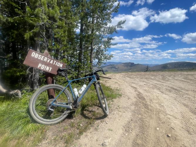
Viewpoint at Mile 11
This viewpoint offers some of the best views available anywhere on the climb. The views from Observation Point provide a panoramic vista looking back east over the corridor and the wilderness that surrounds it.
![]()
Finish at the unmarked highpoint of the climb.