Alpine Summit West (Hwy 39) Bike Climb - PJAMM Cycling

16.9
PDI
10.9 mi
DISTANCE
3,013 ft
GAINED
5.2 %
AVG. GRADE

FULL CLIMB STATS

Page Contributor(s): Ron Hawks, Las Vegas, NV, USA; Bruce Hamilton, La Quinta, CA, USA.

INTRO

"The west side of Alpine Summit (Route 39) is a bit longer and more shallow than its east side but is still a solid ascent and is among the most scenic in Utah. The initial section is within a canyon and passes through Timpanogos Cave National Monument along the way. Soon the road turns right and up the mountain, getting more twisty as you climb. The climb ends at an unmarked but obvious pass within a huge grove of aspen trees (closed in winter - Uinta National Forest - 801-785-3563). AlpineSummit is used at times in the annual Tour of Utah, one of the most difficult stage races in the U.S." (This quote is presented with the approval of John Summerson, from his book, 50 Climbs (by Bike) in Utah, pg. 100.)

PLAN YOUR ROUTE

We've partnered with Sherpa-Map.com to bring you the best route planning tool. With a PRO Membership you can use this climb as a reference when creating your route.

See more details and tools regarding this climb's grade via our interactive Profile Tool.
Information Not Available

If you have any information regarding this climb, we'd like to hear from you. Click the CONTRIBUTE button to share your thoughts with us.

Information Not Available

If you have any information regarding this climb, we'd like to hear from you. Click the CONTRIBUTE button to share your thoughts with us.

Before heading out on any cycling adventure check out our Things to Bring on a Cycling Trip and use our interactive check list to ensure you don't forget anything.
Information Not Available

If you have any information regarding this climb, we'd like to hear from you. Click the CONTRIBUTE button to share your thoughts with us.

ROUTE MAP

MEMBER RATING

Difficulty: Challenging
3
Road
4
Traffic
4
Scenery

CURRENT WEATHER

PJAMM TRIPS ADVENTURE STARTER BUNDLES

Check out PJAMM Adventure's prepackaged (self-guided) cycling trips. They will help you plan, document and conquer your next adventure.
ALL TRIPS
Browse all of our prepackaged trips and find your next adventure!
The American Southwest
United States (AZ,NM,UT)
18 ROUTES
27 POIs
ROUTE STATS (TOTAL)
215.4
mi
DISTANCE
34,866
ft
ELEV. GAIN
Utah: Moab, Arches & Canyonlands
United States (UT)
19 ROUTES
21 POIs
ROUTE STATS (TOTAL)
325.3
mi
DISTANCE
32,871
ft
ELEV. GAIN
Utah: Zion National Park
United States (UT)
20 ROUTES
32 POIs
ROUTE STATS (TOTAL)
256.5
mi
DISTANCE
39,649
ft
ELEV. GAIN

NEARBY CLIMBS (0) RADIAL PROXIMITY

FROM
No Climbs Found

MEMBER REVIEWS & COMMENTS

Let us know what you thought of this climb. Signup for our FREE membership to write a review or post a comment.
Already have an account?

Jul 21, 2021
difficulty: Challenging
scenery: 4
traffic: 4
road: 3
Jul 21, 2021
scenery: 4
traffic: 4
road: 3
Road quality at the start is amazing, but as the road steepens up, it gets a bit crappier; not terrible, just pretty bumpy. Not a ton of traffic and quite a few cyclists. There are some great views of Mt. Timpanogas along the way. I've done it twice and would definitely recommend.
ROUTE MAP
PROFILE TOOL
Route Data
S.G. (%)
hide
Segment Data
hide
CLIMB SUMMARY

Summary by PJAMM’s Ron Hawks.

Alpine Summit can be climbed from two different directions (East near Hwy 92 and West near Hwy 39).  This road is also referred to as Alpine Loop.  The eastern climb is over a good road with some traffic up to Sundance which is a tourist attraction owned by Robert Redford.  After getting past Sundance, which is about 3 miles into the climb, the remainder of the climb is a blast.  There are several switchbacks and the scenery is amazing as we ride through a thick forest of pine trees and quaking aspens.  The road does get a little narrow but the traffic is a lot less than the beginning of the climb and was never really an issue for us.  The grade is pretty consistent with the tougher sections early on in the climb.  After 9 miles we hit the summit which is marked with a sign that is just under 9.000 feet.

Bruce Hamilton and Stacy Topping riding Alpine Loop from the east.

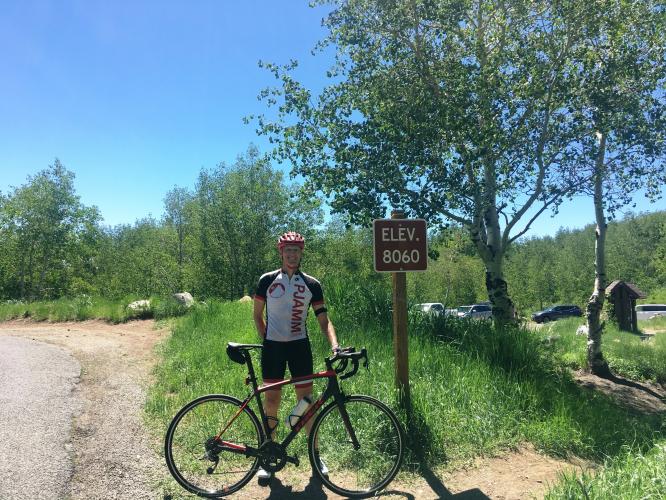
As for the western climb, there is considerable more traffic as it's near the great Salt Lake City.  It's also the road to the Timpanogos Cave National Monument which is a very popular destination where you can take a 1+ mile hike (straight up) and attend an amazing cave tour.  Once you get passed the cave, which we reached after a few miles, the traffic decreased considerably and the views opened up of the Wasatch mountain range.  The grade was pretty shallow in the beginning and increased after the Timpanogos Cave and stayed pretty consistent.  Like the eastern climb, a few switchbacks and thick trees really made the ride very enjoyable.  After 11 miles we hit the summit which is marked with a sign that is just under 9.000 feet.

Road conditions for both roads are pretty good with a few potholes at the beginning of the eastern climb before getting to Sundance.  As for traffic, this is a climb that's probably better done in the middle of the week as traffic will be a little less than the weekends.

Thank you Ron Hawks . . . and . . .

. . . Bruce Hamilton!