14.1
PDI
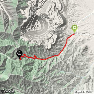
6.6 mi
DISTANCE
2,213 ft
GAINED
6.4 %
AVG. GRADE
FULL CLIMB STATS
Page Contributor(s): Bruce Hamilton, La Quinta, CA; Steven Larsen, West Jordan, UT
INTRO
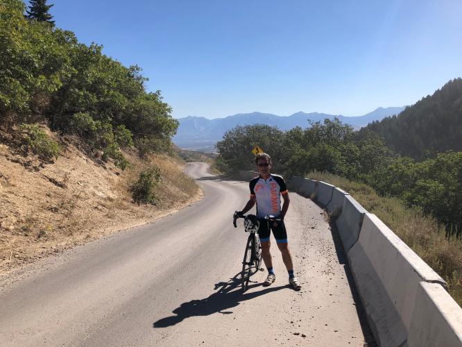
This climb starts southwest of Salt Lake City and is right next to the largest open pit mine in the world. The views initially are dominated by the tiered walls of the mine but soon give way to trees and a canyon.
If you check the Routes in Area (just below the featured image, above) you'll see how stark this climb is compared to all the other climbs around Salt Lake City. Butterfield Canyon is the only climb south of Salt Lake City in the Oquirrh Mountains instead of the many into the Wasatch Mountains west of SLC.
PLAN YOUR ROUTE
6.4% average grade. Ride 6.6 miles gaining 2,230' at 6.4% average grade. 38% of the climb is at 0-5% grade, 53% is at 5-10%, and 9%i is at 10-15%.
See more details and tools regarding this climb's grade via the “Profile Tool” button.
Roadway: A remote narrow two lane road (narrowing to a wide one lane higher up) in fair condition.
Provisions: There is nowhere to get water or food on the route. There are plenty of spots for food and beverages in Herriman and Riverton within a few miles of the start of the climb.
Before heading out on any cycling adventure check out our Things to Bring on a Cycling Trip and use our interactive check list to ensure you don't forget anything.
From PJAMM Ambassador Steven Larsen, West Jordan, UT: A great time to do this ride. Lots of rocks still on the road but only the occasional maintenance vehicle and fellow cyclists to look out for traffic-wise. Also, if you are on a gravel bike (and the snow has melted) you can drop down the back side into middle canyon (steep) gravel for about a mile and a half then pavement through a peaceful and very beautiful canyon complete with campgrounds down to Tooele valley. The return trip up middle canyon is almost as challenging as Butterfield.
ROUTE MAP
MEMBER RATING
CURRENT WEATHER
PJAMM TRIPS ADVENTURE STARTER BUNDLES
Check out PJAMM Adventure's prepackaged (self-guided) cycling trips. They will help you plan, document and conquer your next adventure.
NEARBY CLIMBS (0) RADIAL PROXIMITY
FROM No Climbs Found
MEMBER REVIEWS & COMMENTS
Let us know what you thought of this climb. Signup for our FREE membership to write a review or post a comment.
Already have an account?
LOG IN HERE
marqnielson


One of my favorite local climbs. Traffic is usually pretty low, but the road is not wide. The steep section in the middle is definitely tough (like lowest gear standing for the whole switchback kind of tough). Upper portion can be filled with debris at times. Descent of top half is sketchy, especially if the road is dirty or wet.
trier1992
Pretty tough climb, although short and manageable. The couple mile stretch about 4 miles in is where the real challenge is, as the sections before that are pretty easy. As soon as you get above the first 14% grade, the road starts to have a lot of loose rock and gravel, which isn't that hard to navigate going up because you're going pretty slow, but the way down is a bit perilous. Road is quite narrow, so the traffic that does venture in both directions present another challenge. Just hope the drivers are gracious and safe because there's not much room for error. The leading into the canyon don't get much traffic since you're on the edge of the valley, so riding to the climb is a great way to tack on miles.