
25.8
PDI
12.3 mi
DISTANCE
3,634 ft
GAINED
5.6 %
AVG. GRADE
FULL CLIMB STATS
Page Contributor(s): Doug Jansen, Durango, CO; Erich McAlister, Durango, CO; Tanner Pike, Scottsdale, AZ;
INTRO
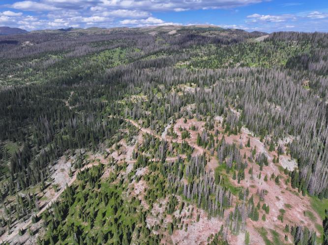
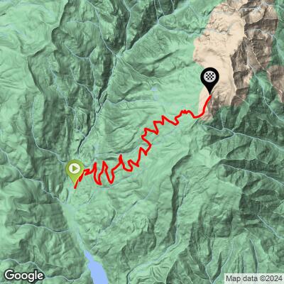
Endlich Mesa Trail is a remote gravel climb into the San Juan National Forest northeast of Durango, Colorado, gaining 3,634 feet over 12.3 miles at a 5.6% average grade. The route follows Florida Road (CR 240) out of Durango, turns onto CR 243 past Lemon Reservoir, and continues on Forest Road 597 (East Florida Road) - a narrow, single-lane forest road that switchbacks up the mountainside for roughly 10 miles to the Endlich Mesa Trailhead near 11,300 feet, then pushes just past it to top out near 11,942 feet at the edge of the high mesa.
Whether it's genuinely rideable on a gravel bike is the real question, and PJAMM's contributors don't fully agree. Doug Jansen: "up to 11.3k it can be ok on gravel bike... it can get pretty loose and washboardy in summer," with large embedded or loose rocks exposed at times. Erich McAlister found it more forgiving: "you won't die on the descent, there's nothing technical, just rough for a very long time - take the biggest tires you can fit." Tanner Pike, who rode it on a mountain bike, rates the surface a 4 out of 5 for a gravel bike; Billy P calls a mountain bike with front suspension the practical minimum, rating it 4 out of 5 for its chunkiness.
This is genuinely remote - trucks and forest-service vehicles use the upper road, which is what keeps it washboarded rather than smooth. There's no water, food, or cell service once you leave Durango, and the road is only reliably open in summer and early fall once snow clears above 10,000 feet.
PLAN YOUR ROUTE
 We've partnered with Sherpa-Map.com to bring you the best route planning tool. With a PRO Membership you can use this climb as a reference when creating your route.
 Endlich Mesa Trail climbs 3,634 feet over 12.3 miles at a 5.6% average grade - deceptively moderate for a climb this remote. The steepest 100-yard pitch reaches 10.6%, the toughest quarter-mile averages 9.3%, and the toughest full mile holds 8.1%.
The final push matters most: the 1.5 miles past the 11,300-foot mark hold roughly 7.1% and add another 560 feet before the road tops out near 11,942 feet at the edge of the mesa - exactly the stretch several contributors flag as the roughest and most demanding part of the ride.
Roadway: The first several miles out of Durango on Florida Road (CR 240) and CR 243 to Lemon Reservoir are paved. Past the reservoir the road turns to graded gravel, then narrows onto Forest Road 597 (East Florida Road), a rough, single-lane dirt road that switchbacks up the mountainside for the final 10 miles or so. Surface reports vary by rider and season - expect washboard, loose gravel, and some embedded or exposed rock, particularly in the upper miles. Bring the largest tires you can fit; several contributors rate the upper sections closer to mountain-bike terrain than a groomed gravel road.
Traffic: Very light bicycle traffic - one contributor notes seeing only a single gravel bike on this road in three years - but the upper road does see truck and forest-vehicle traffic, especially in summer, which is what keeps it washboarded and loose rather than maintained.
Parking: No formal trailhead lot for cyclists starting the climb in Durango; most riders start from town or from a pullout along Florida Road/CR 243 near Lemon Reservoir. Hikers and equestrians bound for the Endlich Mesa Trail itself typically use the Endlich Mesa Trailhead near the end of FR 597, but the bike climb as mapped here starts down in Durango.
No water, food, or services anywhere on the route once you leave Durango - carry everything you'll need for a long day, including extra water for the exposed upper miles near treeline. Tire choice matters more than usual here: contributors recommend the biggest tires you can fit, with mountain-bike-style low gearing to handle the sustained rough sections above the Forest Service boundary.
A mountain bike, or a gravel bike with front suspension, is a safer choice for the upper two-thirds than a fully rigid gravel setup, especially on the descent. With a high point near 11,942 feet, dress in layers - afternoon thunderstorms build quickly in the San Juans in summer, and temperatures up top can be dramatically colder than in Durango.
Before heading out on any cycling adventure check out our Things to Bring on a Cycling Trip and use our interactive check list to ensure you don't forget anything.
Durango is the obvious base - it has bike shops, lodging, and direct access to Florida Road (CR 240), the route's first several paved miles. There's no town or services once you leave Durango, so treat this as a self-supported ride into genuinely remote National Forest terrain. The road is only reliably open in summer and early fall; snow can linger at this elevation into June and returns by October, so check current San Juan National Forest, Columbine Ranger District conditions before planning a trip.
Preview the climb's pitch-by-pitch gradient with PJAMM's Profile Tool before you go - worth it on a climb this long with a genuinely tough final stretch.
ROUTE MAP
MEMBER RATING
CURRENT WEATHER
PJAMM TRIPS ADVENTURE STARTER BUNDLES
Check out PJAMM Adventure's prepackaged (self-guided) cycling trips. They will help you plan, document and conquer your next adventure.
NEARBY CLIMBS (0) RADIAL PROXIMITY
FROM No Climbs Found
MEMBER REVIEWS & COMMENTS
Let us know what you thought of this climb. Signup for our FREE membership to write a review or post a comment.
Already have an account?
LOG IN HERE
