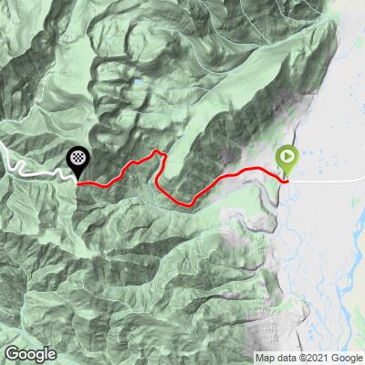
17.6
PDI
5.6 mi
DISTANCE
2,317 ft
GAINED
7.8 %
AVG. GRADE
FULL CLIMB STATS
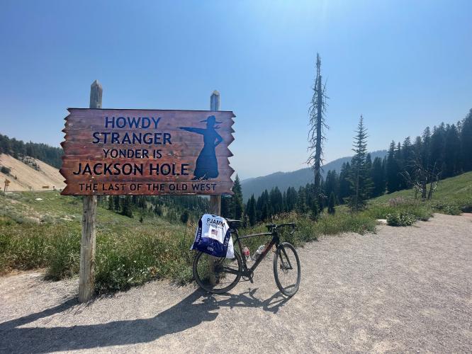
INTRO
"The east side of Teton Pass is a very stout and scenic climb along Route 22 west of Jackson, Wyoming and near the mighty Teton range. The route is steep right from the start and contains sections of double digit grade and also some traffic on many days. The road follows a fairly direct route up the wrinkled mountain ridge and contains some twists and sweeping turns. There are great views to the east at the broad summit on clear days. There is an annual race up its slopes and the hill is a pretty quick in challenging places descent as well..." (This quote is presented with the approval of John Summerson, from his book, The Complete Guide to Climbing (by Bike), 2nd Edition, pg. 235.)
PLAN YOUR ROUTE
The average grade for this climb is 8.1% (8.4% with descent eliminated from the gradient equation). 40% (2.2 miles) of the climb is at grade 5-10%, 36% (two miles) is at 10-15%, and 1% (0.1 miles) is at 15-20%. The steepest quarter-mile is 14.2% and steepest continuous mile is 11.7%.
See more details and tools regarding this climb's grade via the “Profile Tool” button.
Roadway: This climb is on Highway 22 and is in excellent condition.
Information Not Available
If you have any information regarding this climb, we'd like to hear from you. Click the CONTRIBUTE button to share your thoughts with us.
Before heading out on any cycling adventure check out our Things to Bring on a Cycling Trip and use our interactive check list to ensure you don't forget anything.
You can stay in the popular town of Jackson Hole, Wyoming to take on this and other climbs in the area. House rentals are also available in the area.
ROUTE MAP
MEMBER RATING
CURRENT WEATHER
PJAMM TRIPS ADVENTURE STARTER BUNDLES
Check out PJAMM Adventure's prepackaged (self-guided) cycling trips. They will help you plan, document and conquer your next adventure.
NEARBY CLIMBS (0) RADIAL PROXIMITY
FROM No Climbs Found
MEMBER REVIEWS & COMMENTS
Let us know what you thought of this climb. Signup for our FREE membership to write a review or post a comment.
Already have an account?
LOG IN HERE
CliffBriggs


The tradition of Teton Pass Hillclimb Race goes back at least to 1976 when I lived in Jackson Hole. Shortly after riding my bicycle from Rock Springs, Wyo. to Jackson, I got word of this hill-climb. So I rode west from Jackson out to Wilson, a nondescript village at the base of the climb. I took off up and found it to be relentless but despite the fact that my lungs had not yet acclimated to the valley elevation(+/-6,290’) I was still in command of this beautiful climb and it’s surroundings. The top of the pass, close to 8,500’ is saddled with Mt. Rendezvous, 10,040’ to the north. The view of Jackson Hole distracts you from any exhaustion you might feel because you are on top of the world here. Note: In ‘76 I finished the race 1st in my age group and I was 25 years old. 2nd year I finished 3rd overall.
Huber.J
Note, I started in Jackson Hole and completed this via the bike path / Old Pass Road, which is closed for cars and only open to bicycles and foot traffic. Nice to climb without cars! For the descent I took the road, which is VERY fast and trafficked.