
26.4
PDI
11.3 mi
DISTANCE
3,650 ft
GAINED
5.9 %
AVG. GRADE
FULL CLIMB STATS
Page Contributor(s): Kai McGuffin, Steamboat Springs, CO; Dan Borstelmann, Louiseville, CO; Taylor Warren, Boise, ID; Nathaniel Schub, Eerie, CO
INTRO
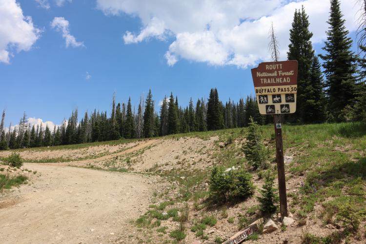
This climb is rideable on a gravel bike, but conditions become increasingly rough and rocky toward the top. Riders on 42–45 mm tires report completing the entire climb without walking, though the final several miles - particularly the 4x4 section - are slow, chunky, and significantly more demanding. Low gearing and strong gravel-handling skills are recommended, while larger tires or a mountain bike will provide a much more comfortable ride, especially on the descent.
PLAN YOUR ROUTE
 We've partnered with Sherpa-Map.com to bring you the best route planning tool. With a PRO Membership you can use this climb as a reference when creating your route.
 Buffalo Pass Road averages a moderate 5.9% over its 11.3 miles, but that number hides a very lopsided profile. The opening quarter-mile is the steepest sustained stretch on the climb, at nearly 11%, and the first mile as a whole still averages over 9%. From there the grade tapers steadily - down to about 8% by mile 2.5 and roughly 7% by mile 5 - as the road settles into gentler, rolling terrain through the forest. The back half includes long, much easier (and occasionally flat) stretches before a final push up to the pass, which is why the overall average sits so much lower than the brutal opening pitch suggests.
Roadway: Buffalo Pass Road is unpaved for essentially this entire climb - hardpacked dirt and gravel through the lower and middle sections that most gravel bikes handle fine. The final few miles toward the pass turn rockier and rougher, with washboard and loose rock that several contributors describe as "extremely rough," best suited to wide tires (45mm+) or a mountain bike. In 2025 the Forest Service completed a reconstruction project on the west side (Dry Lake Campground to about 1.5 miles east of Summit Lake Trailhead) that replaced culverts, widened the roadbed, and resurfaced the route, so the lower-to-middle sections should ride smoother than in past years. As of August 2026 Routt National Forest is under Stage 1 fire restrictions, and the nearby Fishhook Fire has been burning near Rabbit Ears Pass (not on this road) - check current Forest Service alerts before you go.
Traffic: A popular multi-use route for high-clearance 4x4s, ATVs, and mountain bikers accessing the Buffalo Pass/Wyoming Trail network, plus campers headed to Dry Lake Campground. Expect light-to-moderate traffic on summer weekends and during fall hunting season, and very little on weekday mornings.
Parking: No formal cycling trailhead; riders typically start from town or use pullouts near where the pavement ends, close to Dry Lake Campground. The road is gated and closed to vehicles roughly December through late June/early July depending on snowpack.
This is a gravel climb, not a paved one - bring a gravel or mountain bike with at least 40-45mm tires and low gearing; several contributors specifically recommend a mountain bike or a suspension fork for the rocky final miles.
There are no services of any kind once you leave Steamboat Springs - no water, no stores, and limited cell coverage for long stretches - so carry all the food and water you'll need for the full out-and-back, plus supplies to fix a flat given the rocky surface. Weather above 10,000 ft can turn quickly even in summer, so pack a wind or rain layer.
Before heading out on any cycling adventure check out our Things to Bring on a Cycling Trip and use our interactive check list to ensure you don't forget anything.
Steamboat Springs has every traveler service you'll need - lodging, restaurants, bike shops, and a hospital - and sits right at the base of the climb. If you want to camp near the start, the recently expanded Dry Lake Campground (23 sites, reopened in 2025 after a renovation that nearly tripled its size) sits right along Buffalo Pass Road.
Plan to ride roughly July through October; the upper road is typically closed by snow from December into late June. Because this is high-elevation Rocky Mountain terrain, afternoon thunderstorms are common in summer, so an early start is worth it both for weather and to beat any midday 4x4/ATV traffic.
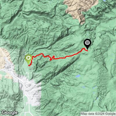
ROUTE MAP
MEMBER RATING
CURRENT WEATHER
PJAMM TRIPS ADVENTURE STARTER BUNDLES
Check out PJAMM Adventure's prepackaged (self-guided) cycling trips. They will help you plan, document and conquer your next adventure.
NEARBY CLIMBS (0) RADIAL PROXIMITY
FROM No Climbs Found
MEMBER REVIEWS & COMMENTS
Let us know what you thought of this climb. Signup for our FREE membership to write a review or post a comment.
Already have an account?
LOG IN HERE
