
29.8
PDI
13.2 mi
DISTANCE
4,399 ft
GAINED
5.9 %
AVG. GRADE
FULL CLIMB STATS
Page Contributor(s): Scott Neperud; Josh Munns, Brigham City, UT; Brent R, UT
INTRO
Willard Peak to Inspiration Point is a 13.2-mile gravel climb in Utah's Wasatch Range above Mantua, gaining 4,399' from about 5,200' to a high point of 9,317' near Willard Peak in the Uinta-Wasatch-Cache National Forest. Average grade is 5.92%, with pitches over 13% near the top, all on unpaved Forest Road 20084 (Willard Peak Road).
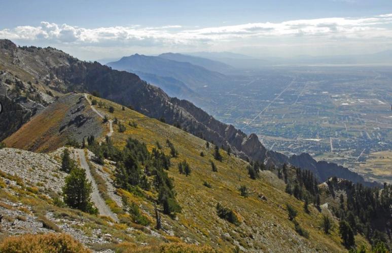
Pavement lasts barely a mile and a half out of Mantua before the road turns to a narrow, rocky, rutted dirt track the rest of the way - this is a gravel or mountain bike climb, not a road ride. It's also a popular OHV and ATV route, so expect real motorized traffic and dust alongside the loose surface, plus sweeping views over the Great Salt Lake, Cache Valley, and the surrounding Wasatch peaks. The road is only open roughly July through October before snow closes it again.
Rider notes: Scott Neperud (7-31-22) - mostly rideable, with a few snow patches to hike over; ruts throughout but smooth for the most part. Josh Munns - rideable on a gravel bike but rough; wider tires at low pressure help, and a rigid mountain bike is even better. Brent R - the road from Willard Basin overlook to Inspiration Point is mostly rideable on a gravel bike, with a couple of quarter-mile hike-a-bike sections along the way - worth it overall.
PLAN YOUR ROUTE
 We've partnered with Sherpa-Map.com to bring you the best route planning tool. With a PRO Membership you can use this climb as a reference when creating your route.
 Willard Peak to Inspiration Point averages 5.92% over 13.2 miles, but the grade varies widely on this unpaved forest road. The steepest quarter mile reaches 13.59% and the steepest full mile averages 11.54%, concentrated on the upper pitches toward Inspiration Point. Expect a mix of punchy, loose-surface ramps and mellower recovery stretches rather than one sustained grade.
See more details and tools regarding this climb's grade via the "Profile Tool" button above.
Roadway: Paved for the first 1.5 miles out of Mantua, then unpaved Forest Road 20084 (Willard Peak Road) the rest of the way to Inspiration Point - a narrow, rocky, rutted dirt/gravel road suited to a gravel or mountain bike, not a road bike. The road is only open roughly July 1 through October 31; deep snow closes it the rest of the year.
Traffic: This is a popular ATV, side-by-side, and dirt-bike route, so expect real motorized traffic and dust, especially on weekends - this is not a quiet backroad.
Parking: Park in Mantua at the base, or use the wide gravel trailhead area partway up where OHV riders park their trailers; Willard Basin, higher up, has a further parking area with primitive camping nearby.
Provisions: None along the route - Mantua has basic services at the base, but there is nothing once you start climbing.
Gear: A gravel or mountain bike with wide, durable tires is strongly recommended given the rocky, rutted surface; a road bike is not a good fit for this climb. Carry all the water you'll need, and expect dust from OHV traffic.
Before heading out on any cycling adventure check out our Things to Bring on a Cycling Trip and use our interactive check list to ensure you don't forget anything.
Mantua is a small town at the base of the climb with limited services; nearby Brigham City has the area's main hotels, restaurants, and bike shops for anyone staying over before or after the ride. Because the road is only open roughly July through October, plan any trip within that window.
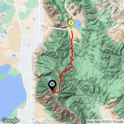
ROUTE MAP
MEMBER RATING
CURRENT WEATHER
PJAMM TRIPS ADVENTURE STARTER BUNDLES
Check out PJAMM Adventure's prepackaged (self-guided) cycling trips. They will help you plan, document and conquer your next adventure.
NEARBY CLIMBS (0) RADIAL PROXIMITY
FROM No Climbs Found
MEMBER REVIEWS & COMMENTS
Let us know what you thought of this climb. Signup for our FREE membership to write a review or post a comment.
Already have an account?
LOG IN HERE
