
27.2
PDI
12 mi
DISTANCE
3,984 ft
GAINED
6.2 %
AVG. GRADE
FULL CLIMB STATS
Page Contributor(s): Caroline Weiler, Salt Lake City, UT; Austin Thielen; George Smith, Provo, UT; Bryan Smith, Fort Collins CO
INTRO
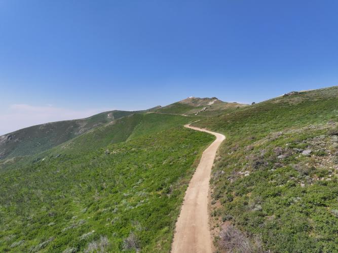
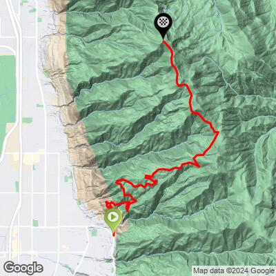
Skyline Drive is a rocky Forest Service road that climbs out of the Wasatch Front foothills above Bountiful, Utah, gaining nearly 4,000 feet over 12 miles to the 9,150-foot summit of Bountiful Peak in the Uinta-Wasatch-Cache National Forest. The grade averages a steady 6.2%, but it's front-loaded with punchy 10-14% pitches lower down before settling into a long grind through gambel oak and maple foothills into fir and aspen forest near the top.
The surface is what sets this climb apart from a typical paved Wasatch ascent - it starts as graded gravel past Francis Peak (home to an FAA radar facility) but turns into rough, chunky jeep road for the final push to Bountiful Peak, rough enough that PJAMM contributors recommend wide tires (40mm+) and ideally some front suspension for comfort. Low gearing matters too - the steepest pitches can outmatch a standard gravel-bike drivetrain.
The payoff is the view: near-constant sightlines over the Great Salt Lake from the Bountiful side, opening up to Ogden and the northern Wasatch from the summit. The road is gated through winter and spring, typically reopening around June depending on snowpack, so the realistic season is June through September.
PLAN YOUR ROUTE
 We've partnered with Sherpa-Map.com to bring you the best route planning tool. With a PRO Membership you can use this climb as a reference when creating your route.
 See more details and tools regarding this climb's grade via our interactive Profile Tool.
Roadway: Paved for the first stretch out of Bountiful, then unmaintained Forest Service gravel/dirt (Skyline Drive/Francis Peak Road) the rest of the way. The lower gravel section is graded and manageable on a gravel bike (roughly 1-2 on a 5-point roughness scale), but the final miles to Bountiful Peak turn into rough, chunky jeep road (4-5 on that same scale) with washouts and loose rock - slow going even for experienced gravel riders.
Traffic: Very light. This is a designated OHV route as well as a bike/hike road, so expect occasional ATV, UTV, and dirt-bike traffic, plus the occasional Forest Service vehicle servicing the Francis Peak radar facility. There's no through car traffic once you're past the pavement.
Parking: The Bountiful Staging Area at the base of the hillside "B" (end of Eagle Ridge Drive) is the standard start/parking point for this South approach - see Start Location above.
There are no services of any kind once you leave pavement - no water, food, or shops along Skyline Drive - so fill bottles and fuel up in Bountiful before you start climbing.
Wide gravel tires (40mm or bigger) are strongly recommended given the rough jeep-road sections near the summit; a few PJAMM contributors have used mountain bikes with dropper posts and 2.0" tires rather than a standard gravel rig, and low gearing helps on the steeper 10-14% pitches.
The summit sits at 9,150 feet, so expect a real temperature swing - warm at the trailhead, cold and windy at the top even in summer. Pack a wind layer for the descent and be ready for afternoon thunderstorms, which build quickly over the Wasatch in summer.
Before heading out on any cycling adventure check out our Things to Bring on a Cycling Trip and use our interactive check list to ensure you don't forget anything.
Skyline Drive is gated and closed to travel through the winter and spring, typically reopening around June 1 depending on snowpack, and closing again by late fall - plan to ride it June through September.
Start early. There's no shade for most of the climb, the upper elevations are prone to afternoon thunderstorms in summer, and an early start gives you the best chance of a calm summit before wind picks up.
Bountiful, at the base of the climb, has all the food, lodging, and bike shop support you'd need - there's nothing along the route itself once you leave town, so stage there before heading up.
ROUTE MAP
MEMBER RATING
CURRENT WEATHER
PJAMM TRIPS ADVENTURE STARTER BUNDLES
Check out PJAMM Adventure's prepackaged (self-guided) cycling trips. They will help you plan, document and conquer your next adventure.
NEARBY CLIMBS (0) RADIAL PROXIMITY
FROM No Climbs Found
MEMBER REVIEWS & COMMENTS
Let us know what you thought of this climb. Signup for our FREE membership to write a review or post a comment.
Already have an account?
LOG IN HERE
