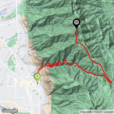
Francis Peak  Bike Climb - PJAMM Cycling

37.5
PDI
13.2 mi
DISTANCE
4,974 ft
GAINED
7.1 %
AVG. GRADE

FULL CLIMB STATS

Page Contributor(s): Steve Larsen, West Jordan, UT; Jack Beyer, Matt Wilden, WA

INTRO

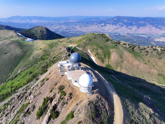
Th number 1 rated climb in Utah is a real adventure that will really test you. It starts on smooth pavement before turning to rough gravel that winds through steep canyons and along sharp ridges. The road surface is mostly a 2 out of 5, but sand, ruts, and summer dust make it challenging. The final stretch is straight, steep, and fully exposed, with the radar domes at the summit pulling you in the whole way, but great views of the Great Salt Flats are your reward!

View the Images tab in our Profile Tool for more detailed information on the road surface.

PLAN YOUR ROUTE

We've partnered with Sherpa-Map.com to bring you the best route planning tool. With a PRO Membership you can use this climb as a reference when creating your route.

See more details and tools regarding this climb's grade via our interactive Profile Tool.
The climb is steady and manageable on a gravel bike, with a road surface that starts around a 2 out of 5 but roughens as you ascend, becoming drier, dustier, and softer through the summer. OHV traffic leaves some switchbacks sandy, and occasional ruts bump the difficulty up to around a 3. Snow patches can linger into early summer, requiring short hike-a-bike sections. About halfway up, riders can choose to detour to Bountiful Peak for a 50 km loop with a bit more pavement, but a rougher 3.5 surface rating. Both descents are fast and loose.

View the Images tab in our Profile Tool for more detailed information on the road surface.


Information Not Available

If you have any information regarding this climb, we'd like to hear from you. Click the CONTRIBUTE button to share your thoughts with us.

Before heading out on any cycling adventure check out our Things to Bring on a Cycling Trip and use our interactive check list to ensure you don't forget anything.
Information Not Available

If you have any information regarding this climb, we'd like to hear from you. Click the CONTRIBUTE button to share your thoughts with us.

ROUTE MAP

MEMBER RATING

Not Yet Rated
-
Road
-
Traffic
-
Scenery

CURRENT WEATHER

PJAMM TRIPS ADVENTURE STARTER BUNDLES

Check out PJAMM Adventure's prepackaged (self-guided) cycling trips. They will help you plan, document and conquer your next adventure.
ALL TRIPS
Browse all of our prepackaged trips and find your next adventure!

NEARBY CLIMBS (0) RADIAL PROXIMITY

FROM
No Climbs Found

MEMBER REVIEWS & COMMENTS

Let us know what you thought of this climb. Signup for our FREE membership to write a review or post a comment.
Already have an account?
ROUTE MAP
PROFILE TOOL
Route Data
S.G. (%)
hide
Segment Data
hide
CLIMB SUMMARY

Francis Peak - Farmington//Class 2

Climb begins in the well kept town of Farmington. The climb is paved for a few miles, then turns to well kept gravel. This route is heavily traveled by ATV’s, motos, trucks, and the like. On the day PJAMM rode this, there was consistent traffic for the entire climb.

As the climb turns to gravel, switchbacks bring you up a magnificent canyon. Here, you’ll enjoy spectacular views and steep drop offs.

After the switchbacks, the climb follows canyons and gradients mellow out. Road quality is decent for the entire climb. There are a few areas of shade on the upper section of the road, but most of the climb is exposed to the hot sun of Salt Lake City (summertime temps that is.)

This climb branches off from the “Skyline Bountiful Peak North” with about 2,000 feet still to climb. The final 2k feet of the climb is exposed and almost dead straight. The road quality is decent up to the summit and can be comfortably ridden on any gravel bike.

The summit of the climb, notable for its large radar domes, is in view for the last 2 miles of the climb. There is a gate about one mile from the summit, which was locked on the day PJAMM rode the climb.

The gate appears to be for cars though, as there was no signage prohibiting vehicle traffic.

 At the summit, there is a sign (shaped like a grave) explaining the name ‘Francis Peak.’

It’s a wrap!

Notes from other PJAMMers:

Steve Larsen (7-30-20) This is rideable on a gravel bike - it’s one of my favorite local gravel rides. I would give it a 2 on the 1-5 road surface scale. It’s fairly heavily used by OHV traffic so some of the switchbacks are a bit sandy. The climb is steady and occasionally steep but never for long. About halfway up you can opt for Bountiful Peak (same distance and climb) which you can ride as a 50 km loop (about 30% pavement). That climb is more like 3.5. Both descents will make you wish for suspension.

Jack Beyer (6-15-24) - It’s mostly rideable there are some snow patches you have to hike over. The roads probably like a 3 (on 1-5 scale) cause there’s lots of ruts but smooth for the most part.

Matt Wilden deteriorates as you ascend and varies quite a bit throughout the season, becoming drier, dustier, and soldier as the summer passes