
30.7
PDI
12.6 mi
DISTANCE
4,393 ft
GAINED
6.6 %
AVG. GRADE
FULL CLIMB STATS
Page Contributor(s): Kristen Tuggle, Layton, UT; Kyle Moncur, UT; Scott Neprud, UT
INTRO
Skyline - Bountiful Peak North climbs Farmington Canyon Road and upper Skyline Drive from Farmington, Utah up to the ridgeline near Bountiful Peak, gaining 4,393 feet over 12.57 miles at a 6.63% average grade. The route shares its first few miles with the neighboring Francis Peak climb, leaving the valley floor around 4,268 feet before the pavement ends and the road turns to a rough, rocky gravel surface for the remainder of the ascent to roughly 8,656 feet.
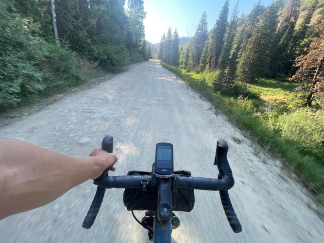
This is a genuine gravel/mountain-bike climb, not a road ride in disguise. Multiple riders who've done it describe the surface as manageable on a gravel bike for most of the distance but with real rough patches. Seasoned gravel riders and mountain bikers should be fine; less experienced gravel riders should expect some walking.
The road climbs through Farmington Canyon's mix of Gambel oak and maple foothills into fir-and-aspen high country, with sweeping views back over Farmington and the Great Salt Lake as elevation builds. Partway up, the route diverges from Francis Peak Road - Francis Peak turns off to its own separate summit while this route continues on Skyline Drive toward Bountiful Peak. Like the rest of the Farmington Canyon road network, the upper mountain gates seasonally (typically closed roughly November into May) and shares the road with a heavy volume of OHV, ATV, and dirt-bike traffic in season, especially on weekends.
PLAN YOUR ROUTE
 We've partnered with Sherpa-Map.com to bring you the best route planning tool. With a PRO Membership you can use this climb as a reference when creating your route.
 The climb averages 6.63% over 12.57 miles, gaining 4,393 feet from about 4,268 feet at the Farmington Canyon mouth to roughly 8,656 feet near the Bountiful Peak ridgeline. The broader Skyline Drive route is known locally for a fairly steady climb rate of around 400 feet per mile, and that consistency matches this route - there's no single brutal pitch, but the grade rarely lets up either, so the difficulty here comes much more from sustained length and a rough gravel surface than from any one steep ramp.
Roadway: The first mile or so out of Farmington is paved, shared with the Francis Peak climb, before the road turns to gravel at the forest boundary. From there it's a rocky, rutted dirt road for the rest of the climb - PJAMM contributors rate the surface around a 2-3 out of 5 for most of the distance, worsening to boulder-strewn, rutted stretches higher up that some riders end up walking. The surface is generally driest and most rideable in mid-to-late summer; expect washboard and loose rock from heavy OHV use.
Traffic: Farmington Canyon Road and Skyline Drive are a well-used OHV and dirt-bike corridor in season, so expect trucks, ATVs, and side-by-sides sharing the road, especially on weekends - weekday mornings are quieter. The upper mountain gate is typically closed from around November into May, so there's no vehicle traffic at all outside that window, though the road itself is also often snow-covered then.
Parking: There's no dedicated trailhead lot at the base. Street parking is available on residential roads near the mouth of Farmington Canyon, the same starting area used for the neighboring Francis Peak climb.
Parking: There's no dedicated trailhead lot at the base. Street parking is available on residential roads near the mouth of Farmington Canyon, the same starting area used for the neighboring Francis Peak climb.
A gravel bike with wide tires (35c or more) is the realistic minimum here, and a mountain bike is a genuinely reasonable choice given how rough parts of the upper road get - riders who've done this climb specifically describe rutted, boulder-strewn sections that call for wider tires or more suspension than a typical gravel setup handles comfortably.
Carry all your own water and food; there's nothing on the route once you leave Farmington. Pack for a big temperature and wind swing between the valley floor and the nearly 8,700-foot high point, and bring a basic repair kit given the rocky surface - flats and rim strikes are a real possibility.
Before heading out on any cycling adventure check out our Things to Bring on a Cycling Trip and use our interactive check list to ensure you don't forget anything.
Farmington sits about 18 miles north of Salt Lake City off I-15, with FrontRunner commuter rail service if you'd rather not drive. It has the usual grocery stores, gas stations, and casual dining near the interstate, plus Lagoon amusement park at the canyon mouth. Salt Lake City offers the widest range of hotels within a 20-30 minute drive, with closer options in Farmington and Layton.
The Forest Service gate near the top typically closes seasonally, roughly November into May - check current status before planning a visit outside summer. Riders looking to extend the day can link over to the neighboring Francis Peak climb, which shares this route's first few miles before splitting off to its own summit.
ROUTE MAP

MEMBER RATING
CURRENT WEATHER
PJAMM TRIPS ADVENTURE STARTER BUNDLES
Check out PJAMM Adventure's prepackaged (self-guided) cycling trips. They will help you plan, document and conquer your next adventure.
NEARBY CLIMBS (0) RADIAL PROXIMITY
FROM No Climbs Found
MEMBER REVIEWS & COMMENTS
Let us know what you thought of this climb. Signup for our FREE membership to write a review or post a comment.
Already have an account?
LOG IN HERE
