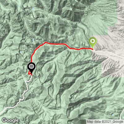
Monarch Pass East Bike Climb - PJAMM Cycling

7.2
FIETS
11.3 mi
DISTANCE
3,048 ft
GAINED
5.1 %
AVG. GRADE

FULL CLIMB STATS

Page Contributor(s): Christopher Jacobs, Byers, CO, USA

INTRO

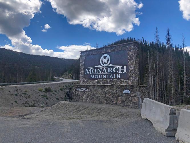
Cycling Monarch Pass East is a great Colorado bike climb along the Interstate 70 Climbing Mecca.

See more details and tools regarding this climb's grade via our interactive Profile Tool.
Information Not Available

If you have any information regarding this climb, we'd like to hear from you. Click the CONTRIBUTE button to share your thoughts with us.

Information Not Available

If you have any information regarding this climb, we'd like to hear from you. Click the CONTRIBUTE button to share your thoughts with us.

Before heading out on any cycling adventure check out our Things to Bring on a Cycling Trip and use our interactive check list to ensure you don't forget anything.
Information Not Available

If you have any information regarding this climb, we'd like to hear from you. Click the CONTRIBUTE button to share your thoughts with us.

ROUTE MAP

MEMBER RATING

Difficulty: Challenging
4
Road
3
Traffic
3
Scenery

CURRENT WEATHER

PJAMM TRIPS ADVENTURE STARTER BUNDLES

Check out PJAMM Adventure's prepackaged (self-guided) cycling trips. They will help you plan, document and conquer your next adventure.
ALL TRIPS
Browse all of our prepackaged trips and find your next adventure!
Colorado: Front Range
United States (CO)
20 ROUTES
46 POIs
ROUTE STATS (TOTAL)
563.5
mi
DISTANCE
73,545
ft
ELEV. GAIN
RMNP: Trail Ridge Road
United States (CO)
13 ROUTES
33 POIs
ROUTE STATS (TOTAL)
258.2
mi
DISTANCE
25,530
ft
ELEV. GAIN

NEARBY CLIMBS (0) RADIAL PROXIMITY

FROM
No Climbs Found

MEMBER REVIEWS & COMMENTS

Let us know what you thought of this climb. Signup for our FREE membership to write a review or post a comment.
Already have an account?

Jul 29, 2023
difficulty: Challenging
scenery: 3
traffic: 3
road: 4
Jul 29, 2023
scenery: 3
traffic: 3
road: 4
I got here as soon as the sun came up on a Friday morning. There isn't really any parking at the base so i went up the climb a mile and parked on the side of the road. This is a steady 5 to 6% grade all the way up. The traffic was moderate but if you aren't there at sunrise the traffic would be dangerous. The view for Colorado climbing is average but it's still a good effort.
ROUTE MAP
PROFILE TOOL
Route Data
S.G. (%)
hide
Segment Data
hide

Climb Profile Not Found
CLIMB SUMMARY

Cycling Monarch Pass East, Colorado - NPS Sign for San Isabel National Forest, forested hillsides along two-lane roadway

Cycling Monarch Pass East, Colorado

Ride 11.3 miles gaining 3,128’ to elevation 11,312’ at 5.2% average grade.

Monarch Pass is located on the Continental Divide at 11,312’ and is at the southern end of the Sawatch Mountain Range of the Rocky Mountains. The grade of the climb is a fairly steady 5-8%, with the steepest quarter-mile at 9.2% at mile five.

Cycling Monarch Pass East, Colorado - photo collage, PJAMM Cycling logo in corner, signs for Monarch Mountain and Monarch Crest, Continental Divide, runaway truck ramp along roadside, stretch of straight, two-lane roadway, views of moutainsides

While this is a great climb and the roadway has a wide shoulder, you are effectively riding on a freeway (Highway 50) with big trucks and cars whizzing by at high speed.  We do not recommend this climb for that reason.

Cycling Monarch Pass East, Colorado - photo collage, PJAMM Cycling logo in corner, signs for Monarch Pass Summit, Elevation 11,312 Feet, bike parked along roadside near evergreen trees

Cycling Monarch Pass East, Colorado - Cyclist Chris Jacobs standing with bike in front of NPS Monarch Pass Continental Divide sign

July 1, 2018: Our friend Chris Jacobs of Byers, Colorado.

Chris was seriously injured when hit by a hit and run driver on Loveland Pass July 2020.

Be well Chris and speedy recovery.