
29.3
PDI
7.2 mi
DISTANCE
3,279 ft
GAINED
8.7 %
AVG. GRADE
FULL CLIMB STATS
Page Contributor(s): Erin Courtney Quinn, New Castle, CO; Patrick Stadler,
INTRO
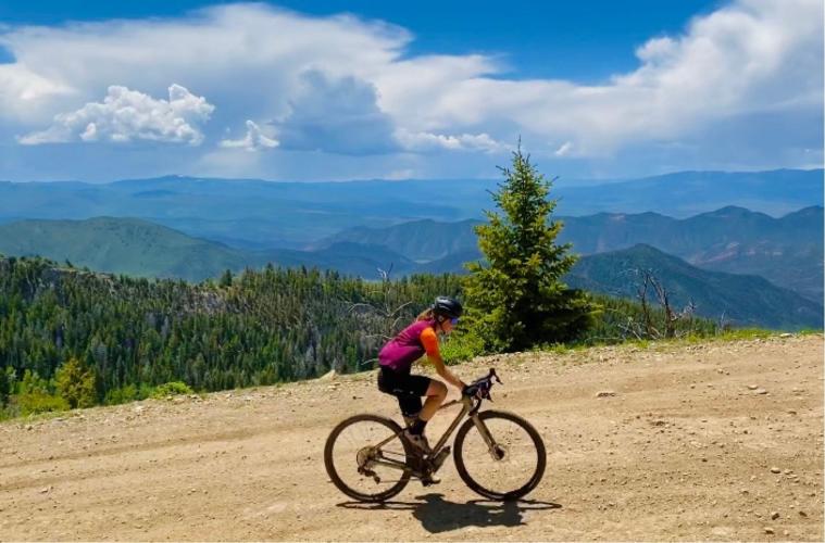
Main Elk Creek Road climbs out of New Castle, Colorado, up a valley in the White River National Forest and onto the Flat Tops - a broad volcanic plateau. The road is paved for about 6.5 miles; the climb tracked here is the gravel section above that point, on Forest Road 603 (locally called Clinetop Road): 7.2 miles gaining 3,279 feet from 6,217 to 9,488 feet, at an 8.7% average grade.
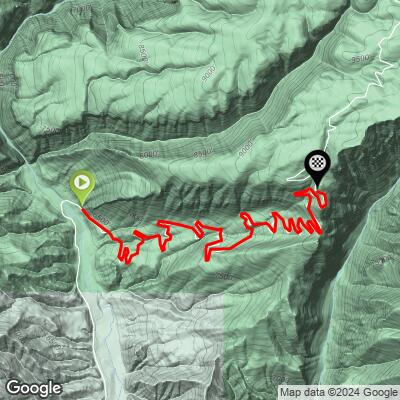
What makes it distinctive is the sheer number of switchbacks - riders and off-road drivers alike describe it as feeling like a million hairpins stacked on top of each other, climbing through oak brush, aspen groves, and pine forest before breaking out onto the open mesa top. Local gravel riders rate the surface a moderate 2-3 out of 5 - rideable on a gravel bike, but rough and demanding on the descent.
Access is via I-70 exit 105 at New Castle: north on Castle Valley Boulevard about 2.5 miles to County Road 245 (Buford Road), then 3 miles to County Road 243 (Main Elk Creek Road). As of July 2026, Garfield County's Sheriff's Office reported flash flooding and mud/rockslide conditions here - a reminder this is a backcountry route exposed to seasonal washouts. Check current county road conditions before you go.
PLAN YOUR ROUTE
 We've partnered with Sherpa-Map.com to bring you the best route planning tool. With a PRO Membership you can use this climb as a reference when creating your route.
 The first roughly 6.5 miles out of New Castle are paved and mild - a warmup, not part of the tracked climb. Once the pavement ends and Forest Road 603 begins, the grade jumps immediately and stays hard: 7.2 miles averaging 8.7%, with the road's countless switchbacks keeping much of it in the high single digits to low double digits rather than settling into a steady rhythm. There's essentially no flat recovery once you're on the gravel - it's a sustained grind from the pavement's end to the mesa top at 9,488 feet.
Roadway: The lower roughly 6.5 miles out of New Castle on Main Elk Creek Road (CR 243) are paved. Above that, the road becomes Forest Road 603 (gravel, locally called Clinetop Road) - a moderately rough, switchback-heavy surface that local riders rate around 2-3 out of 5; expect washboard and looser sections in spots, especially after rain. As of July 2026, Garfield County's Sheriff's Office reported flash flooding, mud, and rockslide conditions on this road - check current county road status before riding, since this is an exposed backcountry route with real washout risk in wet weather.
Traffic: This is a quiet forest road with light use - mostly local traffic, hikers headed to the Hadley Gulch trailhead, and occasional off-road/high-clearance vehicle traffic on the gravel section. It's not a through-route or tourist draw, so traffic volume is low compared to a paved mountain highway.
Parking: There's a public parking area near the Hadley Gulch trailhead, about 5.8 miles up Main Elk Creek Road from the valley floor, if you'd rather start partway up. Otherwise, park in New Castle near the Castle Valley Boulevard/Buford Road junction and ride the full route from town.
This is a gravel-bike climb, not a road-bike one - the tracked 7.2-mile section above the pavement is moderately rough (locally rated 2-3 out of 5), so run wider tires with some tread and enough pressure margin for washboard and loose patches. A wide-range gearing setup earns its keep on the sustained 8.7% average, especially since the grade doesn't let up much before the mesa top at 9,488 feet.
There are no services anywhere on this climb - no water, no store, nothing - once you leave New Castle, so carry everything you need for several hours. The top sits near 9,500 feet in exposed, open terrain, so pack layers even on a warm valley morning; wind and weather can change fast up on the Flat Tops.
Before heading out on any cycling adventure check out our Things to Bring on a Cycling Trip and use our interactive check list to ensure you don't forget anything.
New Castle is the natural base - it's a small I-70 town with basic services (gas, groceries, a few restaurants) and sits right at the base of the climb, about 25 miles west of Glenwood Springs.
Access is straightforward: take I-70 exit 105, head north on Castle Valley Boulevard for about 2.5 miles to County Road 245 (Buford Road), then 3 miles to County Road 243 (Main Elk Creek Road), which you follow up-valley to where the pavement ends and the gravel climb begins.
This is a backcountry forest road, not a maintained tourist route - conditions can change quickly with weather, and the road has seen real flash-flood and washout activity in recent summers (most recently July 2026). Check Garfield County's road conditions before you commit to a ride, and avoid it entirely after heavy rain.
ROUTE MAP
MEMBER RATING
CURRENT WEATHER
PJAMM TRIPS ADVENTURE STARTER BUNDLES
Check out PJAMM Adventure's prepackaged (self-guided) cycling trips. They will help you plan, document and conquer your next adventure.
NEARBY CLIMBS (0) RADIAL PROXIMITY
FROM No Climbs Found
MEMBER REVIEWS & COMMENTS
Let us know what you thought of this climb. Signup for our FREE membership to write a review or post a comment.
Already have an account?
LOG IN HERE
