
23.9
PDI
8.2 mi
DISTANCE
3,334 ft
GAINED
7.8 %
AVG. GRADE
FULL CLIMB STATS
Page Contributor(s): Greg Roberts, Montana
INTRO
PLAN YOUR ROUTE
 We've partnered with Sherpa-Map.com to bring you the best route planning tool. With a PRO Membership you can use this climb as a reference when creating your route.
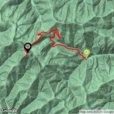
 Marten Creek to Eighty Peak climbs 3,334 feet over 8.15 miles at an average grade of 7.77% - one of the steeper sustained climbs in our database, with essentially no flat recovery sections. The steepest 100 yards averages a brutal 14.64%, and the opening quarter-mile holds 13.64%, so the road throws its hardest pitches right from the base.
Even the steepest full mile averages 10.27%, and the steepest 2.5 miles still average 9.67% - long stretches of this climb sit solidly in double-digit territory, not just isolated ramps. The steepest 5 miles average 7.68%, just under the overall average, confirming there's no meaningful easy section anywhere on the route.
Roadway: Marten Creek Road climbs out of the Clark Fork River valley on the Kootenai National Forest's Cabinet Ranger District, transitioning from paved county road near Trout Creek to maintained gravel forest road, then a rougher, steeper forest road for the final push toward the ridge. A 1,100-foot section of the lower road was realigned by the Forest Service in late 2024 after a failing fill slope; that project is complete and the road is currently in good repair, but expect washboard, loose rock, and the occasional rut higher up. We have not confirmed this route is passable end-to-end on a standard gravel bike - a mountain bike with wider, knobbier tires is the safer choice.
Traffic: Traffic is very light - this is a low-use Forest Service road serving a campground, a wilderness trailhead, and occasional logging or forest-management activity. Expect to see few, if any, other vehicles.
Parking: There's no formal trailhead for this specific climb. Riders typically start from Trout Creek on MT-200, where Marten Creek Road leaves the highway, or from pullouts near Marten Creek Campground a few miles up.
Given the sustained 7-9%+ gradient on a gravel-to-dirt surface, wide tires (35mm or wider) and low gearing are essential - this isn't a climb to attempt on narrow road tires, and a mountain bike may be the more reliable choice for the roughest upper sections.
There's no water or services once you leave Trout Creek, so carry everything you need for the full out-and-back.
Cell coverage is unreliable in the Marten Creek drainage, so let someone know your plan before heading out on a road this remote.
Bear activity is a real consideration in the Cabinet Mountains - carry bear spray and make noise on quieter stretches, especially near the creek.
Before heading out on any cycling adventure check out our Things to Bring on a Cycling Trip and use our interactive check list to ensure you don't forget anything.
Trout Creek, on MT-200 along the Clark Fork River and Noxon Reservoir, is the nearest town with gas, food, and basic services - there's little else nearby, so stock up before heading up Marten Creek Road. The climb is best attempted in summer and early fall; snow lingers into early summer at this elevation in the Cabinet Mountains, and forest roads here aren't plowed.
This is genuinely remote riding - Sanders County has some of the lowest population density in Montana, and the Marten Creek drainage sees far more hikers and hunters than road cyclists. If you're building a longer Montana cycling trip through the Cabinet Mountains or Clark Fork valley, our Routes in the Area tool can help identify other nearby climbs worth combining with this one.
ROUTE MAP
MEMBER RATING
CURRENT WEATHER
PJAMM TRIPS ADVENTURE STARTER BUNDLES
Check out PJAMM Adventure's prepackaged (self-guided) cycling trips. They will help you plan, document and conquer your next adventure.
NEARBY CLIMBS (0) RADIAL PROXIMITY
FROM No Climbs Found
MEMBER REVIEWS & COMMENTS
Let us know what you thought of this climb. Signup for our FREE membership to write a review or post a comment.
Already have an account?
LOG IN HERE
