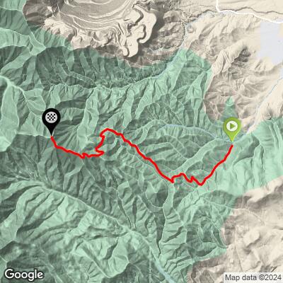
Butterfield Peaks Bike Climb - PJAMM Cycling

32.4
PDI
7.9 mi
DISTANCE
3,638 ft
GAINED
8.7 %
AVG. GRADE

FULL CLIMB STATS

Page Contributor(s): Mike Weber, Jordan, UT; Jared Twitchell; Sage Travis,

INTRO

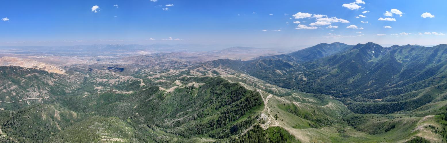
The Butterfield Peaks, reaching an elevation of approximately 9,370 feet, are located in Utah's Oquirrh Mountains just west of the Kennecott Copper Mine. These peaks are characterized by a unique desert-like topography, distinguishing them from other areas within the range. On this climb you'll get views of the Salt Lake City, and the Wasatch and Oquirrh Ranges. 

PLAN YOUR ROUTE

We've partnered with Sherpa-Map.com to bring you the best route planning tool. With a PRO Membership you can use this climb as a reference when creating your route.

See more details and tools regarding this climb's grade via our interactive Profile Tool.
The surface varies from incredibly steep rocky sections to soft sandy dirt.

See the Images tab in our Profile Tool for more detailed information on the road surface. 
Information Not Available

If you have any information regarding this climb, we'd like to hear from you. Click the CONTRIBUTE button to share your thoughts with us.

Before heading out on any cycling adventure check out our Things to Bring on a Cycling Trip and use our interactive check list to ensure you don't forget anything.
During winter and spring, Butterfield Canyon is closed to vehicle traffic.

ROUTE MAP

MEMBER RATING

Not Yet Rated
-
Road
-
Traffic
-
Scenery

CURRENT WEATHER

PJAMM TRIPS ADVENTURE STARTER BUNDLES

Check out PJAMM Adventure's prepackaged (self-guided) cycling trips. They will help you plan, document and conquer your next adventure.
ALL TRIPS
Browse all of our prepackaged trips and find your next adventure!

NEARBY CLIMBS (0) RADIAL PROXIMITY

FROM
No Climbs Found

MEMBER REVIEWS & COMMENTS

Let us know what you thought of this climb. Signup for our FREE membership to write a review or post a comment.
Already have an account?
ROUTE MAP
PROFILE TOOL
Route Data
S.G. (%)
hide
Segment Data
hide
CLIMB SUMMARY

Butterfield Peaks

4th hardest gravel climb in Utah.

There is a large parking lot at the start point of the climb, along with a basic pit toilet. This looks to be a popular starting point for hikes.

The road was closed to vehicle traffic on the day PJAMM rode in early July. The road itself is a mixture of fine, dusty dirt mixed with periodic sections of large rocks.

There are some incredibly steep and rocky sections of road towards the summit - I would recommend a low climbing gear and wide tires on this climb.

See the Images tab in our Profile Tool for more detailed information on the road surface.

The summit is marked by a cell tower of sorts, but no signs at all.

There are views of Salt Lake City from the summit, though the skies were incredibly smoggy/hazy on the day PJAMM rode. There is no shade on this climb and summer temps can be very hot here. PJAMM climbed in 100 degree temps.

Notes from other PJAMMers:

Mike Weber - I did this climb on a gravel bike. It’s smoother on the bottom 1/3 but does have some steep and loose rock sections. Bottom is 2/5 smoother and the top has some 4/5 rougher sections mostly from the steep grade and loose baseball sized gravel. But it’s totally doable on a gravel bike. The trail at the top over to Butterfield road isn’t much fun on a gravel bike but doable with a few hike a bike sections. Then you can take the Butterfield road down.

Jared Twitchell, UT - This climb is rideable on a gravel bike and I know a few that have done it. Grades get up to 20% and it’s pretty rocky and loose in a lot of places so expect to hike a bike a bit. Hard to rate the road surface since it’s relative, but I’d call it a tame mtb trail and a crappy forest road.

Sage Travis - yes, but clipless is recommended.  Don't descend it.