
37.1
PDI
16.4 mi
DISTANCE
5,331 ft
GAINED
6.2 %
AVG. GRADE
FULL CLIMB STATS
Page Contributor(s): CJ Wiggins, UT; Mills Pablo, UT; Hobes Pierre, UT
INTRO
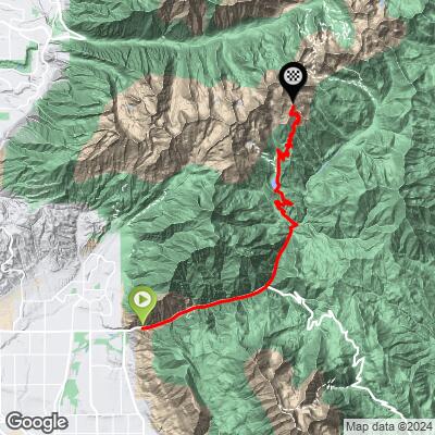
American Fork Canyon cuts into the Wasatch Range above Pleasant Grove, and this climb follows it the whole way up - 16.4 miles and 5,331 feet of gain, starting around 5,100 feet at the canyon mouth and finishing above 10,400 feet in the high alpine terrain near Snowbird's Mineral Basin. It's a big climb by any measure, and one that changes character completely from bottom to top.
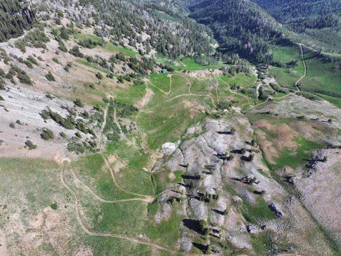
The lower two-thirds run on SR-92, the paved Alpine Loop highway, past Timpanogos Cave National Monument and Tibble Fork Reservoir. Past Tibble Fork the road to Silver Lake Flat turns to gravel, and PJAMM contributors are split on how gravel-bike-friendly the upper section really is - one rates it roughly a 3 out of 5 for gravel-bike friendliness, while another flags the section above Silver Lake as genuinely rough, doable on a rigid gravel bike with bigger tires but chunky by the accounts of riders who've done it.
This is also a seasonal climb. SR-92 and the Alpine Loop close for winter and typically reopen in late spring - the road reopened for 2026 on May 22 - so plan accordingly outside the June-through-October window. The payoff for grinding through the upper gravel is real: this route climbs into some of the highest, most alpine terrain of any gravel climb in Utah County.
PLAN YOUR ROUTE
 We've partnered with Sherpa-Map.com to bring you the best route planning tool. With a PRO Membership you can use this climb as a reference when creating your route.
 The average grade for the full 16.4-mile climb is a moderate 6.2%, but it's not evenly distributed. PJAMM's segment data shows the steepest opening quarter-mile averaging 15.9% and the first mile still at 11.3%, a stiff test right out of Pleasant Grove before the canyon road settles into its long, steady grind.
By the 2.5-mile mark the average is down to 9.9%, and the climb holds in that more moderate range - under 9% - for the long paved middle section up the canyon. Expect the grade to pick back up on the gravel above Tibble Fork and Silver Lake Flat, where the road roughens as it climbs into the high alpine terrain toward the 10,400-foot finish.
**Roadway:** The lower and middle sections run on SR-92, the paved Alpine Loop highway - smooth, well-maintained tarmac past Timpanogos Cave and Tibble Fork Reservoir. Past Tibble Fork, the road to Silver Lake Flat turns to a basic, well-graded gravel road suitable for any gravel bike. Above Silver Lake Flat, riders' accounts get more mixed: PJAMM contributors describe the upper section as rougher and less gravel-bike-friendly, technical enough in spots that a rigid gravel bike with wider tires is recommended over a standard setup.
**Traffic:** SR-92 is a popular scenic highway and Alpine Loop tourist route, so expect real vehicle traffic on the paved lower section, especially on summer weekends and during fall color season. Traffic thins out considerably once the road turns to gravel past Tibble Fork.
**Parking:** There's no single dedicated lot for this full climb since it starts at the canyon mouth in Pleasant Grove; riders typically start from town or a pullout near the SR-92 entrance. Higher up, Tibble Fork Reservoir and the Silver Lake Flat trailhead both have parking areas if you want to split the climb into a shorter ride. As of mid-2026, gates in the canyon (Tibble Fork, Silver Lake Flat) were reported open for the season - check current gate status before heading up, since some Forest Service roads nearby see seasonal closures.
A gravel bike with wider tires - 40mm or more - is the right call, especially for the rougher terrain above Silver Lake Flat. The lower canyon is fully paved, so narrower tires would work down there, but you'll want the cushion and traction once the road roughens higher up. Bring layers: this climb gains over 5,000 feet and finishes above 10,400 feet, where temperatures and wind are a different world from the trailhead in Pleasant Grove, even in summer. There are no services once you're past the canyon mouth, so carry all the water and food you'll need for the day.
Before heading out on any cycling adventure check out our Things to Bring on a Cycling Trip and use our interactive check list to ensure you don't forget anything.
Pleasant Grove sits in Utah County along the Wasatch Front, about 40 minutes south of Salt Lake City and close to Provo, making this an easy add-on to a Utah gravel trip. SR-92 and the Alpine Loop are seasonal - typically open roughly May through October - so check current road and gate status before planning a ride outside peak season; the road reopened for 2026 on May 22. Timpanogos Cave National Monument, partway up the canyon, is worth a stop if you have time, and Tibble Fork Reservoir and Silver Lake Flat both make good turnaround points for a shorter version of the climb.
ROUTE MAP
MEMBER RATING
CURRENT WEATHER
PJAMM TRIPS ADVENTURE STARTER BUNDLES
Check out PJAMM Adventure's prepackaged (self-guided) cycling trips. They will help you plan, document and conquer your next adventure.
NEARBY CLIMBS (0) RADIAL PROXIMITY
FROM No Climbs Found
MEMBER REVIEWS & COMMENTS
Let us know what you thought of this climb. Signup for our FREE membership to write a review or post a comment.
Already have an account?
LOG IN HERE
