
24.5
PDI
19.9 mi
DISTANCE
4,638 ft
GAINED
3.8 %
AVG. GRADE
FULL CLIMB STATS
Page Contributor(s): John Duffett, Hamilton, ON, CAN; Geoff McW, Tahoe, CA; Geoff Martin, La Canada, CA
INTRO
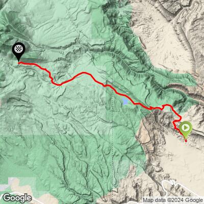
Geyser Creek Road is a long, remote gravel climb that starts in the high desert of Colorado's Paradox Valley and finishes deep in Utah's La Sal Mountains, near the Geyser Pass Trailhead outside Moab. The climb runs 19.9 miles and gains 4,638 feet at a gentle-looking 3.8% average grade, starting at 5,650 feet in Montrose County, Colorado, and crossing the state line into Utah on its way to 9,625 feet.
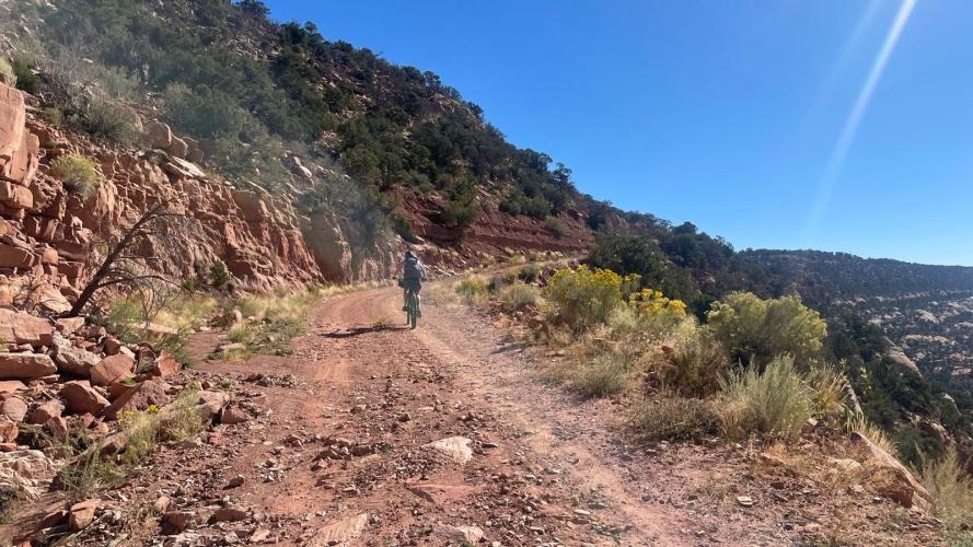
Don't let the modest average fool you - this is a climb of two very different halves. The lower miles along Geyser Creek are a smooth, gradual gravel road, but the final stretch near the finish turns into steep, rocky double track. The steepest quarter-mile averages 11.6%, more than three times the overall average, and multiple PJAMM contributors report walking sections of it even on a gravel bike.
The route finishes near the Geyser Pass Trailhead, the starting point for Moab's famous Whole Enchilada mountain bike trail and access to Manns Peak, Moonlight Meadows, and Burro Pass. It's a genuinely remote crossing of the Paradox Valley into the La Sals, with essentially no services anywhere along the way.
PLAN YOUR ROUTE
 We've partnered with Sherpa-Map.com to bring you the best route planning tool. With a PRO Membership you can use this climb as a reference when creating your route.
 The 3.8% average grade hides a lot of variation. Geyser Creek Road descends briefly at points on the way up - total descent across the route is 663 feet - so the net gain of 4,638 feet is spread unevenly rather than climbed in one steady push.
The real difficulty comes at the very end: the steepest quarter-mile averages 11.6%, the steepest full mile still holds 10.6%, and even the steepest 2.5-mile stretch sits at 10.2% - all concentrated in the rocky double-track section near the Geyser Pass hut that multiple riders have flagged as the crux. By contrast, the steepest 5-mile rolling average is only 7.4%, confirming the lower ~15 miles are a genuinely gentle, sustainable grind before the final sting.
Roadway: Three PJAMM contributors who've ridden this agree the vast majority of Geyser Creek Road is smooth, well-graded gravel, fully rideable on a gravel bike. In their words - John Duffett: "100% for gravel bike. It is probably 98% gravel road, with only a little bit near the Geyser Pass hut that is more like chunky steep double track." Geoff McW: "the majority of this climb is smooth dirt road and readily rideable on a gravel bike. The top few miles are pretty rocky and steep and would be tough but doable on a gravel rig, though true MTB would be better." Geoff Martin: "this is rideable by gravel bike. Last couple miles were steep rocky double track that some of us had to walk sections."
Traffic: Very light. This is a remote backcountry road through Paradox Valley and the La Sal Mountains, with essentially no through traffic - expect the occasional local vehicle, hunter, or fellow rider.
Parking: There's no formal trailhead at the base; riders typically start from a pullout near Paradox, CO. The finish sits near the Geyser Pass Trailhead, a popular staging area for Moab-area mountain bikers and hikers (it's the starting point for the Whole Enchilada trail), so expect more activity, and more parked vehicles, up there in season.
A gravel bike handles this climb, per the contributors quoted above, but bring the mental preparation (and gearing) to walk short sections of steep, rocky double track in the final couple of miles near the Geyser Pass hut - a wide-range cassette and sturdy tires help.
There are no services anywhere along the route - no water, food, or bike shops between Paradox and the Geyser Pass area - so carry everything you need for a full day covering nearly 20 miles and 4,600 feet of gain, most of it remote and at high altitude.
Before heading out on any cycling adventure check out our Things to Bring on a Cycling Trip and use our interactive check list to ensure you don't forget anything.
Moab, Utah is the nearest town with real services, roughly 20 miles from the finish via Geyser Pass Road and the La Sal Mountain Loop Road - stage there for lodging, food, and bike shop support. On the Colorado side, Paradox and Naturita are small but have basic gas and food options.
This route finishes at the Geyser Pass Trailhead, the starting point for Moab's famous Whole Enchilada mountain bike trail - if you're already up there, use our free Sherpa Map route builder to plan additional riding in the La Sal Mountains beyond this climb.
ROUTE MAP
MEMBER RATING
CURRENT WEATHER
PJAMM TRIPS ADVENTURE STARTER BUNDLES
Check out PJAMM Adventure's prepackaged (self-guided) cycling trips. They will help you plan, document and conquer your next adventure.
NEARBY CLIMBS (0) RADIAL PROXIMITY
FROM No Climbs Found
MEMBER REVIEWS & COMMENTS
Let us know what you thought of this climb. Signup for our FREE membership to write a review or post a comment.
Already have an account?
LOG IN HERE
