
27.8
PDI
7.9 mi
DISTANCE
3,262 ft
GAINED
7.9 %
AVG. GRADE
FULL CLIMB STATS
Page Contributor(s): Anton Wintner, Boston, MA; Nora Fierman, Edwards, CO; David Windsor, CO
INTRO
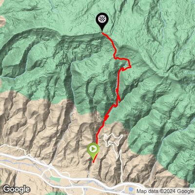
June Creek Road climbs out of Edwards, Colorado, gaining 3,262 feet over 7.87 miles at a 7.9% average grade - starting around 7,635' near I-70 and working its way up toward nearly 10,900' in the mountains above Avon. The lower stretch starts paved before quickly turning to smooth, fine gravel, making it one of the more approachable gravel climbs in the Vail Valley.
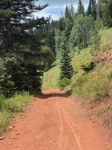
The grade stays consistent and rarely punishing through the lower and middle miles, with the road running along June Creek through a dry, largely shadeless canyon before opening up to views of the Arrowhead and Beaver Creek ski areas to the south. It's a genuinely popular multi-use route - shared with hikers, runners, and dogs - and serves as the main access point into a larger trail network above Avon (including Wild West Ridge).
Higher up, past where casual trail users typically turn around, the route continues into rougher, more remote terrain as it climbs toward its 10,900' high point.
Several riders have weighed in on tire choice for this one (see Gear & Provisions below) - it's rideable on a standard gravel bike, though opinions vary on how comfortable the descent is depending on tire width.
PLAN YOUR ROUTE
 We've partnered with Sherpa-Map.com to bring you the best route planning tool. With a PRO Membership you can use this climb as a reference when creating your route.
 June Creek Road averages 7.9% over 7.87 miles, with 3,262 feet of total elevation gain - a moderate, steady grade for most of the climb rather than a series of steep pitches. Expect the grade to feel easiest in the lower gravel miles near Edwards and to stiffen somewhat as the road climbs into rougher, higher-elevation terrain above 9,000 feet.
See more details and tools regarding this climb's grade via the "Profile Tool" button.
Roadway: Starts paved near I-70, then quickly turns to smooth, fine gravel for the lower and middle miles - genuinely rideable on a gravel bike. Riders describe some sections as chunky enough that wider tires help (see Gear & Provisions), and the upper miles, beyond where the maintained multi-use trail effectively ends, get rougher and less maintained.
Traffic: Low to moderate. June Creek Road/Trail is a popular access route to the trail network above Avon, so expect to share it with hikers, runners, and dogs near the bottom, thinning out considerably higher up.
Access: No closures are currently documented for June Creek Road/Trail itself. Some nearby trails in the area (e.g., Knob Hill) do have seasonal wildlife closures roughly mid-December through mid-April, but June Creek isn't on that list - check the Vail Valley Mountain Trails Alliance's seasonal closures page if visiting in winter or spring.
Parking: Trailhead parking at the June Creek Road access point in Edwards, just off I-70, with a bench, trash receptacle, and dog-waste station at the start.
Anton Wintner: Definitely doable on a gravel bike. I think I did it on a cross bike with 37c tires. Though it is quite chunky so the bigger tire the better.
Nora Fierman: It is rideable on a gravel bike but not super comfy on the way down but rideable.
David Windsor: I have ridden my gravel bike up June Creek. The climb is great. The descent is pretty slow compared to an MTB but there are lots of other ways down as well.
Before heading out on any cycling adventure check out our Things to Bring on a Cycling Trip and use our interactive check list to ensure you don't forget anything.
Edwards sits right along I-70 in the Vail Valley, between Vail and Eagle, making it an easy stop if you're already in the area for other Vail Valley rides. June Creek Road is one of the main ways to access the larger trail network above Avon, so it's worth planning extra time to explore further once you reach the top of the maintained route.
ROUTE MAP
MEMBER RATING
CURRENT WEATHER
PJAMM TRIPS ADVENTURE STARTER BUNDLES
Check out PJAMM Adventure's prepackaged (self-guided) cycling trips. They will help you plan, document and conquer your next adventure.
NEARBY CLIMBS (0) RADIAL PROXIMITY
FROM No Climbs Found
MEMBER REVIEWS & COMMENTS
Let us know what you thought of this climb. Signup for our FREE membership to write a review or post a comment.
Already have an account?
LOG IN HERE
