Bellyache Ridge Bike Climb - PJAMM Cycling

15.4
PDI
5.3 mi
DISTANCE
2,057 ft
GAINED
7.4 %
AVG. GRADE

FULL CLIMB STATS

Page Contributor(s): Mike Persellin, Robbinsdale, MN, USA

INTRO

This 5.3 mile bike climb is located in CO, USA. The average gradient is 7.4% and there is a total elevation gain of 2,057 ft, finishing at 9,074 ft.

Use the profile tool, route map, and weather forecast to conquer this cycling climb.

PLAN YOUR ROUTE

We've partnered with Sherpa-Map.com to bring you the best route planning tool. With a PRO Membership you can use this climb as a reference when creating your route.

See more details and tools regarding this climb's grade via our interactive Profile Tool.
Information Not Available

If you have any information regarding this climb, we'd like to hear from you. Click the CONTRIBUTE button to share your thoughts with us.

Information Not Available

If you have any information regarding this climb, we'd like to hear from you. Click the CONTRIBUTE button to share your thoughts with us.

Before heading out on any cycling adventure check out our Things to Bring on a Cycling Trip and use our interactive check list to ensure you don't forget anything.
Information Not Available

If you have any information regarding this climb, we'd like to hear from you. Click the CONTRIBUTE button to share your thoughts with us.

ROUTE MAP

MEMBER RATING

Not Yet Rated
-
Road
-
Traffic
-
Scenery

CURRENT WEATHER

PJAMM TRIPS ADVENTURE STARTER BUNDLES

Check out PJAMM Adventure's prepackaged (self-guided) cycling trips. They will help you plan, document and conquer your next adventure.
ALL TRIPS
Browse all of our prepackaged trips and find your next adventure!
Colorado: Front Range
United States (CO)
20 ROUTES
46 POIs
ROUTE STATS (TOTAL)
563.5
mi
DISTANCE
73,545
ft
ELEV. GAIN
RMNP: Trail Ridge Road
United States (CO)
13 ROUTES
33 POIs
ROUTE STATS (TOTAL)
258.2
mi
DISTANCE
25,530
ft
ELEV. GAIN

NEARBY CLIMBS (0) RADIAL PROXIMITY

FROM
No Climbs Found

MEMBER REVIEWS & COMMENTS

Let us know what you thought of this climb. Signup for our FREE membership to write a review or post a comment.
Already have an account?
ROUTE MAP
PROFILE TOOL
Route Data
S.G. (%)
hide
Segment Data
hide
CLIMB SUMMARY

Cycling Bellyache Ridge, Colorado - bike parked in brush next to stone sign for Bellyache Ridge

Cycling Bellyache Ridge, Colorado

Ride 5.3 miles gaining 2,085’ at 7.5% average grade.  

This one is a bit of an outlier but we really enjoyed it. The climb is just off I-70 and not far from Vail, Loveland, and Guanella Passes. There is mild and slow moving traffic along the climb and the road is in very good condition.  The steepest quarter mile is 10.4% and begins at mile 1.1.

Cycling Bellyache Ridge, Colorado - photo collage, PJAMM Cycling logo in corner, bike parked against tree trunk in forested area with tall thin trees, cyclist on roadway next to trees, bike parked in grass next to wooden fence, view from top of climb overlooking valley below

Cycling Bellyache Ridge, Colorado - PJAMM Cycling logo in corner, parking lot at climb's start

Plenty of parking at the start of the climb.

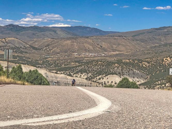
Cycling Bellyache Ridge, Colorado - cyclist climbing up two-lane roadway, dry, mountainous lands behind

Cycling Bellyache Ridge, Colorado - photo collage, PJAMM Cycling logo in corner, cyclist climbing large wooden near sign for Red Sky Golf Club, sign at entrance of golf course, bike parked on roadside overlooking golf course

Although we don’t see them much along the way, the area includes a couple of golf courses and Golf Academy.

Cycling Bellyache Ridge, Colorado - photo collage, PJAMM Cycling logo in corner, views along the climb of stretches of roadway surrounded by low, brown mountains, PJAMM Cycling white SAG van, climb gradient profile

Cycling Bellyache Ridge, Colorado - photo collage, PJAMM Cycling logo in corner, PJAMM Cycling white SAG van parked on roadway at end of pavement, end of climb

Finish where the pavement ends.

Climb report by Mike Persellin of Robbinsdale, Minnesota, USA.  Photos by PJAMM Cycling.

Bellyache Ridge is a tough, short climb up from I-70 near Wolcott, Colorado.  You are on the western, dry side of the Great Divide, and it can be quite warm.  The start is at 7,017 feet and the finish is at 9,102 feet; so altitude is not quite as much a factor as with most of the other Colorado climbs.  The climb is not overly difficult, with just a few double-digit segments.  Once you’re past the golf course, the views over the Eagle River valley and I-70 corridor are stunning.  It’s a new, wide road with little to no traffic, and the road ends where residential development stops.  It would not be surprising if the road and finish are extended in the near future.

Cycling Bellyache Ridge, Colorado - cyclist Mike Persellin climbing on roadway surrounded by scrub brush and low mountains, blue sky beyond

Thank you Mike!