
26
PDI
11.6 mi
DISTANCE
3,789 ft
GAINED
6.1 %
AVG. GRADE
FULL CLIMB STATS
Page Contributor(s): Grahampa Steve; John Kingry, Park City, UT; Lily Halvorson; Sam Gross, Heber City, UT; Dan Hoops, Orem, UT
INTRO
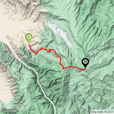
The Wasatch Wall is an 11.6-mile gravel climb that claws its way out of Heber City, Utah's Center Creek valley and up into the Uinta-Wasatch-Cache National Forest, gaining roughly 3,800 feet on its way to a high point of about 10,060 feet on the western slope of the Uinta Range. At a 6.11% average grade it doesn't sound dramatic on paper, but that number hides a brutal profile - the steepest quarter-mile stretches average over 13%, with sustained pitches in the 9-14% range higher up the mountain.
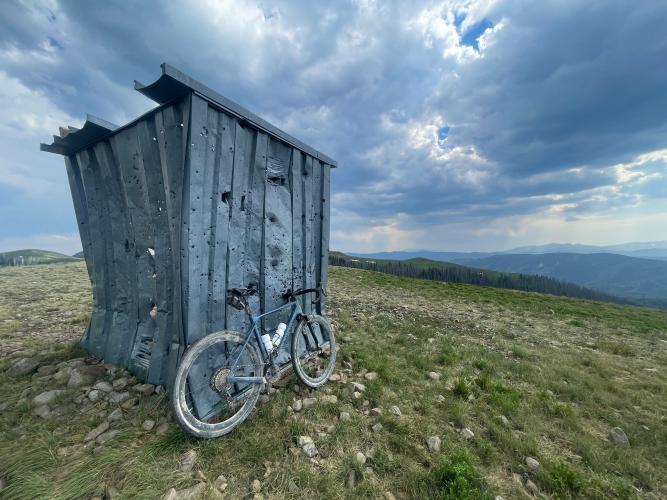
What makes the Wall notorious isn't just the grade - it's the surface. Riders who've climbed it describe loose, chunky gravel with only one clean line through the steepest sections, and several report having to walk short stretches regardless of fitness. Wide, mountain-bike-style tires (40mm and up) are the consensus recommendation; a typical 32-35mm gravel tire is not enough here.
The climb owes its reputation to the Wasatch All-Road, a Utah Gravel Series race created by former pro cyclist Jeff Louder (2008 Tour of Utah winner) and revived in 2022. The Wall anchors the event's longest "Bigfoot" course each August, some 82 miles with over 10,000 feet of climbing, while the shorter "Sasquatch" distance has since been rerouted to climb nearby Lake Creek instead.
Outside of race day, the road sees very little traffic and no formal maintenance schedule, so conditions can vary noticeably from year to year - especially above 9,000 feet, where snow can linger into early summer.
PLAN YOUR ROUTE
 We've partnered with Sherpa-Map.com to bring you the best route planning tool. With a PRO Membership you can use this climb as a reference when creating your route.
 Wasatch Wall averages 6.11% over 11.6 miles - a deceptively modest number for a climb this hard. The segment-by-segment data tells the real story: the steepest quarter-mile point averages 13.41%, the steepest full mile still holds at 11.45%, and even the steepest 5-mile stretch runs 8.3%. In other words, there's no flat recovery mile anywhere on the climb - it's sustained hard grades stacked on top of a loose, unstable surface for the full 11.6 miles.
Riders and race reports consistently describe repeated pitches in the 9-14% range, concentrated in the middle third of the climb, which lines up with the steepest-segment numbers above. Expect to be out of the saddle often, and expect your legs to be working harder than the 6.11% average suggests - gear accordingly.
Roadway: The Wasatch Wall runs on unpaved Forest Service roads climbing out of Center Creek into the Uinta-Wasatch-Cache National Forest. The surface is loose, chunky gravel that gets rougher the higher you climb - riders who've completed it rate the upper third as a 4-5 out of 5 on a smooth-to-rough scale, with only a single rideable line through some of the steepest pitches. It's doable on a gravel bike with wide tires, but a mountain bike is a realistic and arguably better choice given the combination of grade and surface.
Traffic: This is a quiet, low-traffic forest road for most of the year, with essentially no through-traffic beyond local recreational use, hunters in season, and occasional Forest Service vehicles. The one exception is race day each August, when the Wasatch All-Road sends riders up the Wall as part of its Bigfoot course.
Parking: There's no dedicated trailhead or lot at the base. Riders typically stage from Heber City - about 30 minutes from Park City and an hour from Salt Lake City - and either ride out to the start or find a pullout near where Center Creek Canyon Road turns to gravel. Check current Forest Service access conditions before you go, since this area can be gated or closed seasonally.
PJAMM's own contributors who've ridden the Wall are consistent on one point: bring wide tires. Grahampa Steve rode it on 42c Pathfinders and rated the surface around a 4.5 out of 5 on a smooth-to-rough scale. John Kingry found it rideable on a gravel bike but noted some steep sections are loose with deep gravel and only one clean line, rating most of the climb a 3 with pockets of 5. Lily Halvorson climbed it on 40mm tires that "aren't very knobby" and reported a lot of sliding out, recommending wider mountain-bike-style rubber instead. Sam Gross, riding it more recently, currently rates the surface closer to a 2 - a reminder that conditions here shift from season to season and year to year.
Bottom line: run the widest tires your bike and gearing will accommodate, and bring your lowest gear - this is not a climb to be under-geared on. There's no water, food, or services on the climb itself, so stock up in Heber City before you head out.
Before heading out on any cycling adventure check out our Things to Bring on a Cycling Trip and use our interactive check list to ensure you don't forget anything.
Heber City is your base for this one - about 30 minutes from Park City and an hour from Salt Lake City International Airport, with basic lodging, dining, and bike shops in town (Park City has more options if you want to spend more). The Wasatch All-Road race takes over the Wall each August, so if you're not racing, a summer weekday visit means you'll likely have the road to yourself.
Best season is roughly June through September - above 9,000 feet the road can hold snow well into early summer, and Utah's high country is prone to afternoon thunderstorms in late summer, so plan to be off the exposed upper sections by early afternoon. Before you head up, use our free Weather tool to check current conditions at the 10,060-foot summit, since at that altitude conditions can differ dramatically from what you see down in Heber City.
ROUTE MAP
MEMBER RATING
CURRENT WEATHER
PJAMM TRIPS ADVENTURE STARTER BUNDLES
Check out PJAMM Adventure's prepackaged (self-guided) cycling trips. They will help you plan, document and conquer your next adventure.
NEARBY CLIMBS (0) RADIAL PROXIMITY
FROM No Climbs Found
MEMBER REVIEWS & COMMENTS
Let us know what you thought of this climb. Signup for our FREE membership to write a review or post a comment.
Already have an account?
LOG IN HERE
